Live feeds are a great way of showing up to date and dynamic content in your web maps and apps. Many of these datasets have global coverage, but what can you do if you want to focus on a smaller area like the UK?
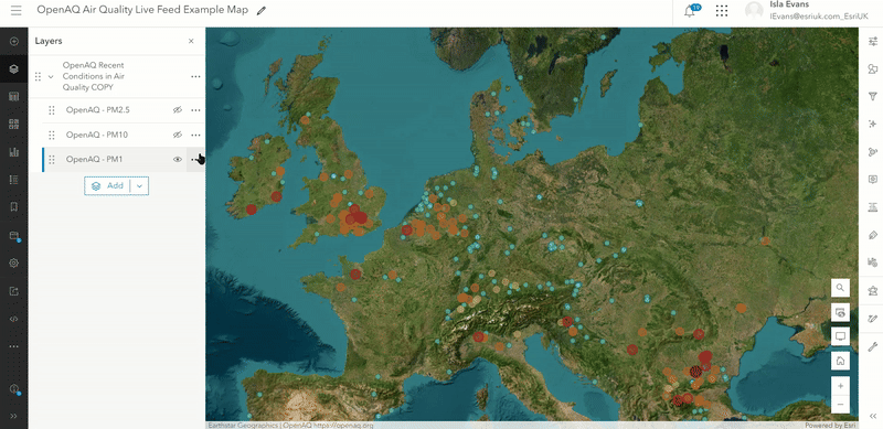
While you can’t clip live feeds using typical methods (as they would halt the automatic update process) there are a few different approaches you can take. I’ll take you through these options in this blog using the Recent Conditions in Air Quality from the OpenAQ community in the Living Atlas. This dataset shows global concentrations of small air particles that could cause respiratory diseases and updates every hour.
Option one: filter the data by spatial extent
Many datasets will include geographic category fields such as countries or counties in their attribute information. You can use these fields to filter the data to the area you want to show.
For example, you could click the three dots next to the layer name in ArcGIS Online and select Show table to see if the data contains geographic attributes across the areas you want to filter to. Once you save your own copy of the layer you can use the filter button in the properties tab to filter the spatial extent with the geographic attribute identified earlier.
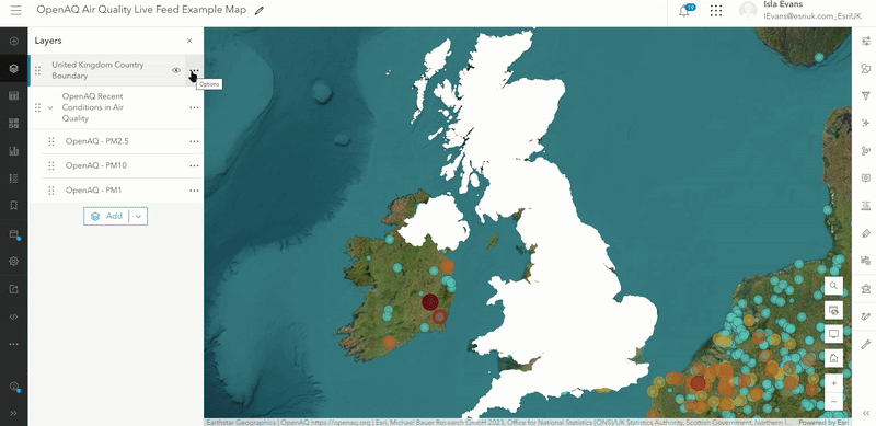
Option two: use blending modes to visually filter
If you don’t have the geographic fields you need, then another option is to cover the parts of the map that you don’t want the data to show within. Playing around with the different blending modes will help you achieve different effects.
For example, one way you could do this would be to add both the live feed data and the polygon of the area you want the live feed data to appear in your web map in ArcGIS Online. One useful UK polygon layer you can use is the United Kingdom Country Boundary dataset.
Once you make sure the polygon layer is on top of the live feed data layer and its transparency is set at 0%, you can apply the Destination Atop blending mode to the polygon layer in the layer properties and watch the magic happen.
For more information about blending modes see the use blend modes documentation page and this helpful blog. For another example of how blending modes help visually filter you can see our UK Precipitation Forecast blog. However, please note that this method may be less suitable for large live datasets as it could impact load time and responsiveness.
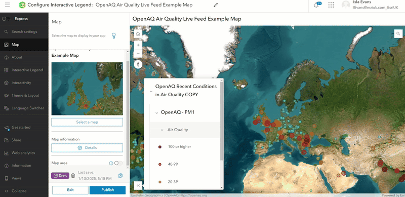
Option three: limit the view extent
If you intend to use the data in a web app then you may be able to skip the options above and simply limit the zoom out extent instead. Look for ArcGIS Instant App templates that allow you to turn on a Navigation Boundary setting, such as the Interactive Legend, Zone Lookup, Nearby, Attachment Viewer and Media Map templates.
All you need to do is turn off Express Mode and configure the Map Area in the Map settings. As part of setting the Map view you can turn on and adjust the Navigation boundary for your app.
And there you have it; three simple ways to focus the attention in your maps and apps on the areas you want, while still using dynamic live feed data. Try one, or a combination of these, to get the exact effect you want!
Further helpful resources
- For more information about live feeds in the Living Atlas please see the Putting the “Live” in Living Atlas of the World blog.
- Find out more about UK datasets in the Living Atlas through the Esri UK Living Atlas Hub site.
- See the status of the live feeds in the Living Atlas in the Live Feeds Status page.