In his long career in contingency planning and emergency response in Lincolnshire, Steve Eason-Harris has seen plenty of changes. Perhaps the most important of these has been the change that he has driven himself – the adoption of digital mapping. With his enthusiasm and passion for geographic information system (GIS) technology, he has brought digital mapping solutions to the Lincolnshire Resilience Forum. Now, the 30+ category one and category two first responders that are part of this multi-agency group use GIS dashboards and apps to coordinate effective emergency responses, protect property and save lives.
The lightbulb moment
The story begins more than ten years ago, in December 2013, when the Lincolnshire coastline was impacted by a North Sea tidal surge, sending water cascading through the streets of the Lincolnshire town of Boston. Nearly 600 properties were flooded, and hundreds of people were evacuated from their homes, in what was the worst flooding in the area for 60 years. The Lincolnshire Resilience Forum sprang into action, providing essential emergency support for local people, but such was the huge scale of this incident, that usual processes were placed under enormous strain.
Eason-Harris remembers the Boston Floods well, not just for the devastation caused to the local community, but also for the lightbulb moment that the event stimulated. “There were flooded houses everywhere and we were trying to keep track of evacuated properties and rest centres using marker pens on printed maps and an early version of Resilience Direct mapping,” he recalls. “We had data in spreadsheets, but it was incredibly difficult to convey the extent of the incident to all the agencies involved, as events were unfolding. I realised we needed more effective digital mapping.”
While at university, many years before, Eason-Harris had encountered GIS technology and used it to map the nighttime migratory patterns of moths in Lincolnshire. Recalling this brief experience of using digital mapping, he realised that digital maps could transform the Lincolnshire Resilience Forum’s ability to respond effectively in future flooding events and other large-scale emergencies. With passion and growing conviction, he began to talk maps with anyone who would listen and gradually built momentum for a pilot initiative.
Important lessons learned
This first foray into "truly" digital mapping was a simple one. With an almost non-existent budget, Eason-Harris used a combination of free software from the Internet, desktop software and Resilience Direct maps to create an electronic map of the county that partner organisations could use in an emergency. It was thoroughly tested in 2019 when a month’s rain fell in three days, causing massive flooding in and around the market town of Wainfleet near Skegness. “We had only basic capabilities, but the potential was obvious,” says Eason-Harris.
The following year, COVID-19 emerged and emergency response mechanisms were put under unprecedented pressure. The basic, pilot digital mapping system was heavily used, but failings emerged. For instance, partners found that they couldn’t combine data from different sources, so couldn’t really build up a full picture of what was going on. Only one person at a time could edit the current map, and if they locked it and went off shift, it was locked for everyone. The technology was also too complicated for non-GIS users to just pick up and use quickly. “COVID was a big eye opener for us,” Eason-Harris explains. “It showed us that intuitive digital mapping was essential, but that our digital mapping solutions were not fit for purpose.”
Again, it was Eason-Harris who took the lead in finding and delivering a better solution. After discovering the Esri COVID-19 Dashboard, he felt certain that GIS could do what Lincolnshire Resilience Forum needed it to do; he just needed to find the right GIS technology and get some support. “Looking back, it was a real leap of faith,” he says with a chuckle. “I had confidence that GIS could transform the effectiveness of our emergency responses but needed to prove it.”
A fresh approach
With his dogged determination, Eason-Harris was soon successful in securing Local Resilience Forum Innovation Funding from the Government to embed mapping into response and recovery mechanisms. So, at last, he had internal support, funding and momentum to develop a full proof of concept solution. Recognising that it could, potentially, be rolled out to local resilience forums nationwide, he contacted Esri UK for guidance.
Working with Esri UK’s Professional Services team and using Esri’s ArcGIS technology, Eason-Harris led the development of a suite of solutions for emergency planning, response and recovery. Key amongst these is an interactive ArcGIS dashboard that consolidates data from third party systems and provides a common operating picture for teams from all partner organisations. When emergencies occur, the dashboard can be viewed online, on mobile devices and on huge screens in the County Emergency Centre, giving everyone an up-to-date, accurate understanding of fast-changing situations.
Eason-Harris was also the driving force behind a suite of mobile apps, designed to make it easier for first responders to collect and share information on the ground about everything from collapsed bridges to evacuated homes. A particularly pivotal app has been developed with ArcGIS Survey123 to register evacuated people at rest centres and make sure they have the medication and support they need in times of crisis.
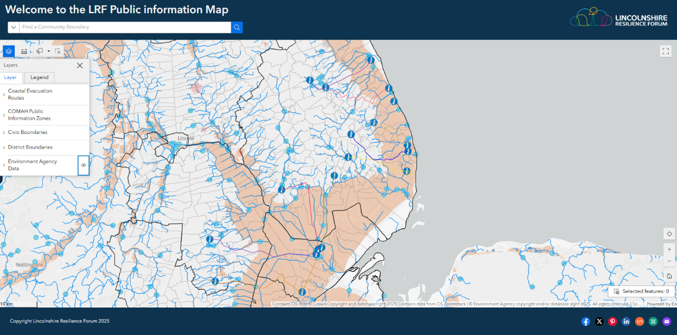 A view of one of the Lincolnshire Resilience Forum’s ArcGIS Dashboards
Proof of success
It is a sign of the times perhaps that Lincolnshire Resilience Forum’s new ArcGIS dashboard, apps and web-maps have been put thoroughly to the test. The newly developed mapping solution was first put through its paces during the 2022 national flooding exercise ‘FloodEx’ with great success, allowing commanders, planners and other stakeholders to quickly get to grips with ground truth from multiple sources. Then, in successive severe storms, including Storm Babet in 2023 and Storm Henk in 2024, multiple agencies used ArcGIS to coordinate their responses to communities affected by flooding and blocked roads. An evacuation of around 80 households at Fiskerton, near Lincoln, was managed highly successfully using ArcGIS when a river bank was at risk of being breached.
While Eason-Harris is an unassuming man, he is understandably proud of the feedback that he has received from senior commanders within Lincolnshire’s response agencies. “One of the first things that commanders ask when incidents occur is ‘where is it’, followed by ‘how big is it’ and ‘who is affected by it’, and the simplest way to show them is on a map,” he explains. “Now that they have used ArcGIS, they really understand the power of digital mapping.”
The thing that Eason-Harris likes most about GIS is its ability to take data from multiple sources and make it understandable to all kinds of users. He points to a recent community-led exercise in Horncastle, when volunteers from all backgrounds successfully used an ArcGIS app to register people evacuated from the vicinity of a hypothetical gas explosion. “ArcGIS demystifies complexity,” he says. “Everyone can get to the information they need, in a format that they can understand and use it to respond to emergencies effectively.”
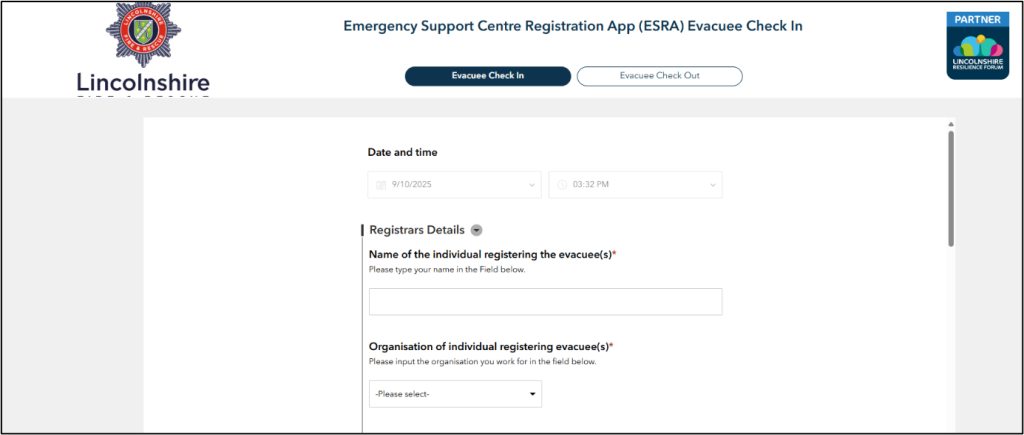 An ArcGIS app for registering people evacuated from their homes
Ready for anything
Eason-Harris’s role today is very broad and covers more than just the ongoing development of GIS apps and systems. He leads on creating resilient communities, supports Boston Borough Council’s contingency planning and helps to coordinate the county’s team of ready-for-anything volunteers, a group of local people who are willing to help out during a crisis by being deployed wherever they will be most effective.
Eason-Harris himself is, of course, also ‘ready for anything’, as emergencies of the most unexpected kind can occur at any time, necessitating a rapid reaction. In March 2025, two tankers collided in the North Sea, discharging pollution, which started to wash up on Lincolnshire and Norfolk beaches. He was able to use ArcGIS to quickly build an ArcGIS dashboard and survey app for collecting data about the debris, making it available to all responding agencies across multiple regions, which helped to highlight the extent of the pollution and inform plans for clean-up and recovery activities.
Together with his team members, Eason-Harris is continuing to fully embed the use of GIS for contingency planning and responding to emergencies in the county. He now plans to build ‘ready-to-go’ solutions with ArcGIS that can be rolled out rapidly in future scenarios, such as apps for evacuating multi-occupancy, high-rise buildings. He also has ambitions to incorporate drone imagery into the central ArcGIS system, which might be useful for identifying the locations of caravans in holiday parks, if evacuations are needed.
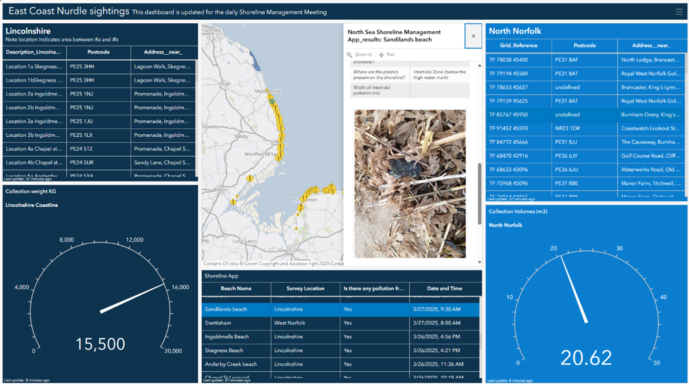 The ArcGIS dashboard for monitoring ‘nurdle’ pollution, washed up on beaches
While modest about the role he has played, Eason-Harris acknowledges that it is largely his enthusiasm for GIS that has led to it becoming embedded in Lincolnshire Resilience Forum’s operations. The GIS-led approach to data sharing and data collection in emergencies that he has championed over more than ten years is now becoming recognised as good practice, and other local resilience forums are following suit. As Eason-Harris rightly says, “Digital mapping started out at Lincolnshire Resilience Forum as a nice thing to have; now it’s very much essential.”
 Steve Eason-Harris - Lincolnshire Resilience Forum