Esri Maps for SharePoint can be used to extend the capabilities of Microsoft’s SharePoint by adding easy to configure and use mapping capabilities that can be integrated with SharePoint data, ArcGIS for Server and ArcGIS Online. It allows SharePoint users to quickly and easily create, display and share information on interactive maps and answer otherwise unseen questions about their data. It comes with a wide range of out of the box configurable functionality and no programing is needed to get started. I have been working with the API a fair bit recently and wanted to point out a few features and potential uses especially in light of the recent release of ArcGIS Online and the integration SharePoint has with this new mapping medium.
Esri Maps for SharePoint consists of three main components:
- Geocoding workflow – used to add location information to SharePoint lists that contain address data. ArcGIS locators are used to add a location to a list item and the workflow can be configured to run when new items are added or changed in a list.
- Location field – adds a column to SharePoint lists that displays the location of each list item on an interactive map.
- Web map part – enables a rich display of SharePoint lists, ArcGIS Server services, and Spatial Data Services on an interactive map.
The web map part comes with a wide range of configurable functionality including a ribbon interface, bi-directional interaction between SharePoint lists and the map, heat maps, clustering, geoprocessing services and much more functionality to give a rich mapping experience.
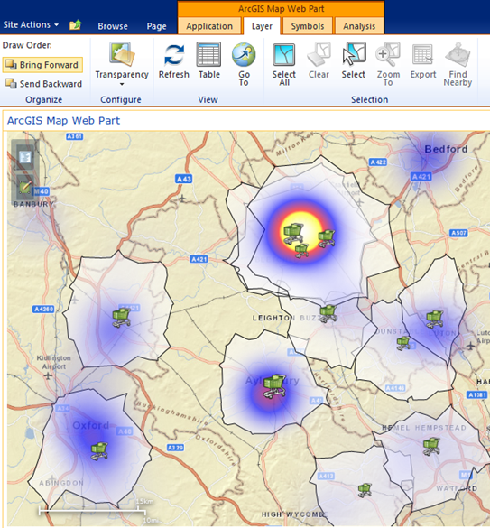
Esri Maps for SharePoint being used in retail to help analyse store performance & potential new store locations
Integration with ArcGIS Online
Esri Maps for SharePoint integrates tightly with Esri’s new cloud platform, ArcGIS Online (AGOL). AGOL provides a platform to store and share mapping data and maps that can be utilised within the SharePoint web map part. The potential here is huge, ArcGIS Online already provides a new way of sharing and working with GIS & mapping data and integrating this with SharePoint opens up even more doors to share information that can be used for better communication and strategic decision making within an organisation.
All the components of Esri Maps for SharePoint integrate with ArcGIS Online automatically. The basemaps and locators that come configured with Esri Maps for SharePoint use ArcGIS Online services. These can be configured to your own Servers of course but the default is ArcGIS Online.
The web map part can utilise ArcGIS Online services in a couple of ways. It has a map centre that allows you to log into your ArcGIS Online account. From here, ArcGIS Online web maps can be searched and added to the SharePoint web map part. You can search for web maps, view your own web maps or view your organisation’s group maps. Once a web map has been added to the map you can add additional data layers on top of it such as SharePoint data or other ArcGIS Online data.
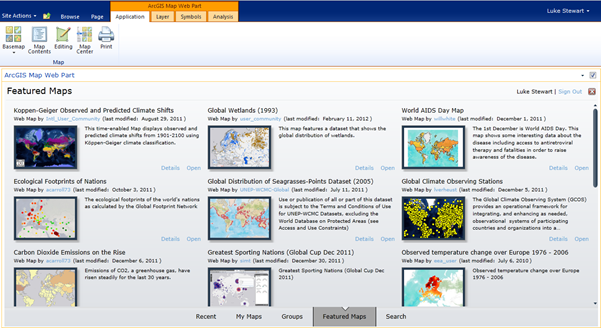
The map centre where you can search and add web maps from ArcGIS Online
ArcGIS Online data sets can also be added to maps created in SharePoint. When adding layers to a map you can add layers from SharePoint, ArcGIS Server or ArcGIS Online. Using ArcGIS Online data is a great way to bring in additional value added data into your application if you do not have an ArcGIS Server running, to supplement SharePoint data. Critical organisation data can be added and viewed alongside SharePoint data that could tell a compelling story. Data that other people have shared on ArcGIS Online can also be added to give even further insight.
ArcGIS Online feature services are editable and can be edited from within a SharePoint map as well as web maps and mobile devices. This allows for total collaboration and data collection within an organisation with the potential to view data as it is updated in real time.
Integrating UK Data & Online Data Services from Esri UK
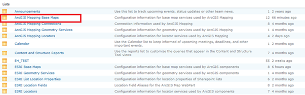
Sometimes you may wish to display data that is in British National Grid (BNG). Whilst ArcGIS Online will re-project this data on the fly there are valid reasons why you may wish to work with data in BNG. To do this you can add your own ArcGIS Server BNG cached basemaps such as Ordnance Survey maps. When Esri Maps for SharePoint is installed a set of configurable lists are created, here you can add your own basemaps and locators. To do this you will need administrator rights for the list. You can navigate to the ArcGIS Mapping Base Maps list by looking at all site content
The lists should be in this section of the site as below:
You can also add your own locators into SharePoint including the newest version of Esri UK’s LocatorHub, this is a UK centric locator that has been formatted for UK addresses. The new version has a standard ArcGIS REST end point that can be consumed easily in SharePoint. This will mean your geocoding workflows will be as accurate as possible against your UK address data.
Esri Maps for SharePoint can easily be configured to work with UK data making it an even more attractive and powerful tool for many organisations.
The web map part with OS Master Map basemap
The API in use in Esri UK
Esri UK are among the thousands of organisations using SharePoint. We have Esri Maps for SharePoint deployed on our SharePoint site for a number of uses, for example to show the location of our Partners within my Partners & Alliances site in SharePoint.
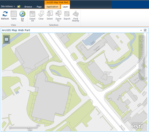
We have also used it to build a desk finder application. With this app you can search for a colleague and find their desk location in our head office, Millennium House. People can edit the map in the morning and afternoon to add the hot desk location where they are sitting for workers without permanent desks, so they can easily be located if needed.
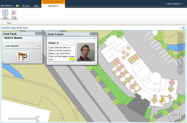
The Esri UK desk finder application in action
Final Thoughts
Working with Esri Maps for SharePoint has been quite enjoyable over the past months. I have very quickly built numerous demonstrations to show its capabilities that are now available to the whole of Esri UK to show off. I have used it in conjunction with my ArcGIS Online Subscription account and even integrated UK data sets with ease.