BIM (Building Information Modelling) has been around for a while but has become a really hot topic. I thought it might be useful to share a high level view of what BIM is and how we – as GIS professionals – fit in. The UK government define it as: a collaborative way of working, underpinned by the digital technologies which unlock more efficient methods of designing, creating and maintaining our assets.
Managing digital information about assets throughout their lifecycle is well established in many industries but there is a push to apply this in the construction industry. The Cabinet Office have mandated that from next year all government projects will use: collaborative 3D BIM (with all project and asset information, documentation and data being electronic).
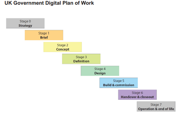
Traditionally, detailed information would be created at each of the stage in a building’s lifecycle but with limited transfer of information across the stage boundaries. The BIM process is aimed at ensuring that digital information becomes part of the deliverables for each stage and that it adheres to a structure that allows the intelligence to be re-used in subsequent stages. The process isn’t yet covered by standards but are defined in two key specifications from the BSI: PAS 1192-2 which covers the design and construction stages and PAS1192-3 which covers the operational stage. The specifications use the same set of stages as UK Government Digital Plan of Work:
If you need to know more about these then the BIM task group is a good place to look.
The guidelines are technology neutral and instead mandate consistency and openness of data. Which is where two more acronyms come in: IFC – Industry Foundation Class is a data specification for 3D data – and COBie – a data standard focused on tabular data called the Construction Operations Building Information Exchange. A 3D model of a building (or site) is a key piece of the jigsaw and is now commonplace in building design. This sometimes leads to the CAD tools being referred to as BIM software, but really BIM is a process not a type of software.
Where does GIS fit in?
Anywhere that it is a useful tool to the practitioners. We know GIS to be an invaluable tool for managing and understanding data that has; a geographic element, associated attribution and benefits from being managed as separate layers. We are seeing it being used in the early planning and design stages, the construction stage and through the operational stages.
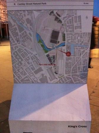
I recently went to an AGI asset Management SIG event that was hosted by Argent. We heard about how GIS is being used as a key tool within the BIM process for the ongoing redevelopment of Kings Cross.
We also heard from an information manager working primarily with Quantity Surveyors (turns out they do more than count bricks) who talked about learning that GIS offers a valuable source of information into the analysis they do. He also talked about wrestling with CAD to separate the information from a 3D model into distinct layers of information to support their analysis. I do look at the world through GIS tinted glasses but bringing the information into a GIS seems as if it would give them a more flexible tool for their analysis.
One of the things I found interesting about the Kings Cross development was how ArcGIS had become a common visualisation tool on the development sites with people from different disciplines using the maps as a shared picture of the project. It’s even used for their public signage.
In part two I’ll be taking a more detailed look at how ArcGIS sits in the technology landscape that underpins BIM.
A follow up post explores the the role of GIS across the lifecyle stage in more detail.