It’s a year since ArcGIS Enterprise was introduced in the 10.5 release and the 10.6 release adds new options to get more out of your Web GIS deployment. There are efficiency improvements for managing your content, improvements to collaboration options, new mapping styles and a big change to user licensing.
Content management and admin
Portal has had a revamp, with a new look to the Groups and Content tabs. This supports a new navigation experience that makes it quicker and easier to find items – using tabs, filters and a focused search. For example, here we can see all of the content that has been modified in the last 30 days (you could even set the time period to a custom range):
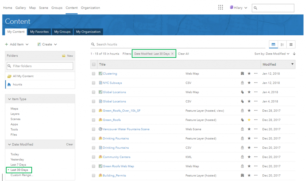
Image courtesy of the ArcGIS Enterprise Team
Server performance has been optimised for many service management operations. So you should enjoy faster publishing for new services and find stopping and starting existing services quicker.
10.6 gives you new options for printing maps and layouts. The ArcGIS Enterprise print service now supports vector tile layers. You can use the arcpy.mp toolbox to script your own custom print tools from Pro. The release also includes performance improvements for the PrintingTools print service, which generates a printable document using predefined layouts.
ArcGIS Monitor is a new product that works with ArcGIS Enterprise to give you a better understanding of system usage and performance. As well as getting reports, you can use alerts and notifications to help detect and resolve potential problems. Find out more about it here.
Mapping, analysis and editing
The clustering smart mapping style has come to ArcGIS Enterprise. The renderer automatically clusters data points as you change zoom level, letting you show general trends and exact locations in the same map using a single layer. The amount of clustering (which you can adjust) changes with scale and the exact data points are shown when zoomed in.
You can now share custom web tools directly from ArcGIS Pro to your ArcGIS Enterprise portal. Web tools are an update to the traditional way of publishing geoprocessing services, from models or scripts, that integrate the service with your web GIS apps. Your new web tools can be accessed from the portal’s standard analysis tools so it’s easier for your users to access custom analytics. To support this, a new user privilege has been introduced with 10.6 to allow publishing of web tools.
Hosted feature layer views are now available in ArcGIS Enterprise. By creating a view of your feature data, you can apply different editing settings and other privileges – then choose which groups the view is shared to. One scenario would be using a view to allow a wide audience to view a layer while limiting edit access to a small group. You can also configure feature or field definitions to control what information is exposed through the view.
Collaboration
To meet the needs of your organisation you may be managing content across more than one ArcGIS portal. Collaboration lets you share data across ArcGIS Enterprise deployments or with ArcGIS Online and there are new options at 10.6. In a collaboration between two ArcGIS Enterprise portals you can share feature layers as copies, creating a new hosted feature layer in the recipient’s Enterprise portal. The synchronization status of a collaboration is now reported in the workspace for better status checking and troubleshooting. Collaborations now provide a content deletion policy, governing what happens to data sent and/or received after leaving or deleting a workspace or collaboration.
ArcGIS Enterprise licensing update
One of the big benefits of a modern web GIS is the ability to open up access to business data through intuitive maps. As of January 1, 2018, all ArcGIS Enterprise Standard and Advanced customers are eligible to add Viewers (Level 1 Named Users) at no additional cost. Administrators will be able to provide viewer-level access to everyone in the organisation who needs to view secured layers, maps, apps, and services within ArcGIS Enterprise. If you are considering adding a lot of new Viewers you will need to consider whether additional ArcGIS Server capacity (cores) is needed, to maintain the performance of the services that underpin your maps.
There are lots more changes in the release, including new features for GeoAnalytics Server, GeoEvent Server and Image Server. You can see the full list on the What’s New page.
![]()