Shining a light on the UK’s best new content in the Living Atlas

Content
19th December 2018

Have you been exploring the Living Atlas recently? Whether you are new to the Living Atlas, or a frequent visitor, this blog is here to give you a handy round up of some of this years’ top new UK content that we think is worth shouting about. As a community fuelled effort, thousands of organisations are sharing their best maps, apps and data layers. We now have over 300 items from the UK alone. From environmental datasets, to housing and retail, there is something here for everyone.

 So let’s have a look 2018’s best new UK datasets!

Ministry of Housing, Communities and Local Government


From Homelessness, Rough Sleeping, Social Housing, Right to Buy, Social and Affordable Rent, House Price… it’s all in there. MHCLG have put 14 datasets into the Living Atlas this year that we think you will love. Many of these datasets have already had well over 2000 views.

Go check it out and compare average house price across the country with the MHCLG’s House price dataset. No surprises there...

RNLI

The Royal National Lifeboat Institution have been embracing the power of GIS this year – we’ve blogged a bit about it too – but they are now sharing that data through the Living Atlas. Have a look at their layers including RNLI Lifeboat Stations, Support Centre, Lifeboat fleets and more.
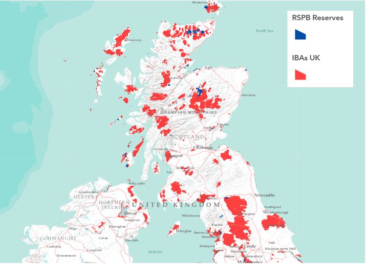
 

See where the most lifeboat call-outs are taking place – this dataset has had nearly 1000 views already since it was introduced in May.

Geolytix


Geolytix have released a new dataset showing every supermarket in the UK! These have been rooftop located and attributed with store name, address including postcode, the Geolytix seamless towns and localities, and open date where known and a four-way classification for size band of store.

RSPB

Not to be left out, RSPB have added datasets showing the locations of all RSPB Reserves and Important Bird Areas around the UK. Have you visited any of your local reserves recently? Maybe it’s time to venture further afield? You can click on a reserve to see if it has visitor access. The RSPB Reserves layer has now had nearly 900 views.

RSPB.JPG


Office for National Statistics


ONS have the most datasets of any UK customer in the Living Atlas with over 80 datasets for you to now explore. They continued to update their content, this year submitting another 20 items with new or updated content.

Electoral regions, UK Wards, Authority Districts, Parishes, Countries, NHS England Regions, Index of Place Names in Great Britain… to name just some of the great new content that ONS have submitted this year.

Check out this new dataset which shows the boundaries for Local Enterprise Partnerships in England. We can see local authorities finding this one very useful.

CGG Robertson

UK customers are helping to build a global picture too, with datasets such as Sedimentary Basins of the World by CGG Robertson. Sedimentary basins are areas of subsidence in the Earth’s crust where sediments are able to accumulate. CGG Robertson have defined over 800 of these basins worldwide based on basement outcrop, structure, total sediment isopachs, subsidence regime and more! Go check it out now in the Living Atlas.


A big thank you to everyone who’s contributed, and we hope you enjoy exploring some of our great new content, as the Living Atlas continues to get better and better.

Have a dataset you would like to see in our Living Atlas? Check out this blog to see how you can nominate your layers or email DataCurator@esriuk.com

Content