OS Open Zoomstack Trial
One of the challenges of building compelling mapping products is creating great maps that provide consistent cartography and data across a range of scales. While ArcGIS contains many global multi-scale maps, in the UK it can be a lot of work to combine the various sources of data that we have to create these. To help with this the Ordnance Survey have launched their OS Open Zoomstack Trial. This explores ways to deliver an integrated zoom stack of open data to users. The trial provides the data in 3 different download formats as well as an online API that serves up Vector Tiles. There are instructions on the site for working with the download formats in ArcGIS, but if you are interested in directly accessing the OS vector tiles in ArcGIS then read on.
What are the Open Zoomstack Vector Tiles
Vector tiles are pre-generated tiles of data that are efficient to download and display as base mapping in web applications and desktop tools such as ArcGIS Pro. They can be customised to display the data in different styles according to your cartographic needs. They are fast to display and can scale with high resolution screens to create beautiful maps. OS are hosting the Open Zoomstack data tiles and providing a number of map styles that can be used to draw them. The default styles provided are not directly compatible with ArcGIS, but one of the benefits of Vector Tiles is that you can easily restyle them without having to recreate the data tiles. We have used this capability to provided a sample version of one of the default styles (OS Outdoor) that you can use directly in ArcGIS but points back to the OS hosted data tiles.
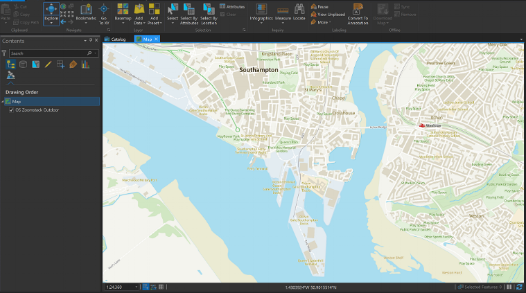 OS Outdoor style loaded into ARcGIS Pro
How to Access the OS Tiles
Firstly sign up for the OS trial. The sample style is registered in ArcGIS Online as a vector tile layer and included in a web map so that you can add the OS Trial data tiles directly into ArcGIS using these items. To find the items in ArcGIS Online just search for “zoomstack”, or find them in the following group:
You can use the webmap as the basis of your ArcGIS online projects, add the tile service directly into your map or your ArcGIS Pro project, or even just embed the map in a blog.
Contains OS Data Crown copyrights and database right 2018
Feedback
Please make sure to sign up for the OS Trial and provide feedback to them directly on how you would like to use the OS Open zoomstack within your ArcGIS workflows. This service is just a sample that will be available during the OS trial period, and we would love to hear your feedback on the use of the service in the comments below. As well as this OS provided service, we are also running a separate trial of OS Opendata vector tiles that are hosted by Esri UK and provide services in British National Grid, you can find more details here.
![]()