This blog was updated in March 2025 to reflect new changes coming to the user types.
The ArcGIS system contains a diverse portfolio of individual products that meet the wide needs of our customers. From a capability and technology perspective this choice is great news, from a licensing perspective it could make life a little complex. The user type model, introduced in 2018, successfully combined capabilities and apps together to align with the needs of different GIS users.
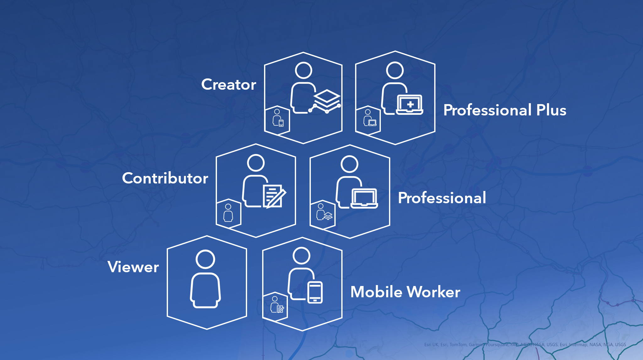
In June 2024, we updated the user type license model to use six role-based user types. The six choices progressively expand the capabilities, apps and services that a user has access to – going from Viewer through to Professional Plus.
The user types align with key roles in an organisation and simplify and streamline the administration of licenses.
We’re excited to announce that four more products will be included in this model, further expanding access to ArcGIS capabilities, apps and content. Effective from June 2025, ArcGIS Navigator, ArcGIS Business Analyst Web App Standard, ArcGIS City Engine and ArcGIS Urban will be licensed through user types, detailed below.
Collaborator user types
These roles support different levels of collaboration within your organisation – from viewing content to different data editing roles.
Viewer
Allows the user to securely view maps, apps, and dashboards. This includes viewing content from ArcGIS for Microsoft 365.
Contributor
This user type allows users to review and edit features using apps in ArcGIS Online or ArcGIS Enterprise. Users can also interact with data from ArcGIS Microsoft 365 and ArcGIS GeoBIM. It also includes everything from Viewer. This new user type expands the capabilities of the current Editor user type.
Mobile Worker
The Mobile Worker user type includes all the capabilities of the Contributor but adds secure access to the ArcGIS mobile apps: ArcGIS QuickCapture, ArcGIS Survey123 and ArcGIS Field Maps. It also includes ArcGIS Workforce.
Effective from June 2025, ArcGIS Navigator will be included in the Mobile Worker user type and above and will no longer be sold separately.
Map and app configuration user types
These user types allow you to create and configure layers, maps and apps in your organisation. They also include access to ArcGIS Pro.
Creator
The Creator user type addresses the needs of users that are responsible for creating content and apps in ArcGIS Online or ArcGIS Enterprise. This also includes access to ArcGIS Image for ArcGIS Online and ArcGIS Excalibur (which previously required additional licenses). What’s more, it also includes access to ArcGIS Pro Basic giving users access to editing, analysis and data management tools; as well as creating output maps and charts. Note: this user type combines the Creator and GIS Professional Basic user types.
In June 2025, ArcGIS Business Analyst Web App Standard will be included in the Creator user type and above, giving many users access to this app for the first time. It will no longer be sold separately and the ArcGIS Business Analyst Standard Bundle will be discontinued. Note: ArcGIS Business Analyst Web App Advanced will continue to be sold separately.
Professional
This user type includes all of the capabilities of Creator. A Professional user also has access to the additional capabilities of ArcGIS Pro Standard – which includes features like versioned editing, creating mosaic datasets and the Utility Network toolbox. For Professional users working with ArcGIS Enterprise they also get access to the Advanced Editing user type extension. This user type expands the previous GIS Professional Standard user type.
Following the June 2025 update, ArcGIS CityEngine will be included in the Professional user type – a level down from where it was previously included – and will no longer be sold separately.
Professional Plus
The Professional Plus user type includes access to ArcGIS Pro Advanced and adds access to the most popular ArcGIS Pro extensions including: ArcGIS 3D Analyst, ArcGIS Data Reviewer, ArcGIS Image Analyst, ArcGIS Spatial Analyst and ArcGIS Workflow Manager* It also includes access to ArcGIS CityEngine. All of the capabilities of the other user types are included. This user type expands the previous GIS Professional Advanced user type.
With the June 2025 update, ArcGIS Urban will be included in the Professional Plus user type and will no longer be sold separately. ArcGIS Urban Suite will be discontinued, with Professional Plus users having access to both ArcGIS Urban and ArcGIS CityEngine.
These nested user types allow organisations to manage the access to ArcGIS capabilities that their users need with a simpler administrative model. The six user types also make it easier to scale your user access to a growing range of capabilities as your needs expand.
To learn more about user types please visit the ArcGIS user types webpage. There is a dedicated webpage with more about the changes planned for June and the products included.
*The ArcGIS Pro extensions included in Professional Plus are: ArcGIS 3D Analyst, ArcGIS Data Reviewer, ArcGIS Geostatistical Analyst, ArcGIS Image Analyst, ArcGIS LocateXT, ArcGIS Network Analyst, ArcGIS Publisher, ArcGIS Spatial Analyst, and ArcGIS Workflow Manager.