You might have heard about vector tiles recently but not yet used them. Here I will explain what they are, why you should consider using them and how to create them.
What are vector tiles?
Vector tiles contain vector representations of data across a range of scales. Unlike raster tiles, they can adapt to the resolution of their display device providing better display quality, have dynamic labelling including rotation and can easily be restyled by end users for multiple uses.
Esri has published lots of global vector basemaps that you can use in web maps and web apps. Have a look at them in the Living Atlas. Here in the UK, we have published several GB vector tile services based around OS Zoomstack data and you can read about them in this blog.
Vector tiles offer great flexibility and endless display options – you can create your own styles from existing vector tile layers without having to host or maintain the underlying data yourself. So, for example, if you’re using the GB Background style but you want to highlight the main roads in red, you can do that by changing just that specific road feature’s style with the Vector Tile Style Editor. Similarly, if you wanted a map that doesn’t show some features, you can simply suppress them. You can easily save your changes as a new style and share it with your organisation for others to use too.
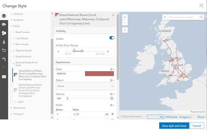
Changing the style of the GB Background vector tile’s National Roads (small scale) in the Vector Tile Style Editor
Where can they be used?
Vector tiles can be published to and consumed within ArcGIS Online or ArcGIS Enterprise as a vector tile package .vtpk. Vector tiles are supported almost everywhere across the ArcGIS system, but not in ArcMap.
Creating Vector Tiles
Before you begin, it’s important to make sure that your map is valid and efficient for vector tile creation. Here are a few of the key things to check:
- Vector tiles can be created from any map or basemap in ArcGIS Pro that contains point, line, polygon or multipoint features – any other unsupported layers including annotations, representations and dimensions must be turned off or removed altogether. Vector tiles can’t be created from a Scene.
- Ensure the map’s metadata has been completed (fill in the description field as a minimum).
- Avoid complex symbology and symbol effects where possible. For example, features that contain hatched or gradient fills, markers along lines or polygon outlines will not be rendered properly in the resulting tiles.
- To reduce data density, consider generalising complex features. Some generalisation occurs automatically when you generate vector tiles but tools such as Simplify Building, Simplify Line and Simplify Polygon can help.
- Limit scale ranges – too many vertices at smaller scales can result in tiles that don’t perform quickly.
For more information on how to author a map for vector tile creation, have a look at the ArcGIS Pro documentation here.
I’m going to use an extract of the OS Open Zoomstack data which I’ve clipped out for Edinburgh. This data is in the British National Grid projection and I’ve authored my map in ArcGIS Pro using the OS Outdoor style.
The easiest way to convert my map to vector tiles is by sharing it as a web layer. Here are the steps I took:
- Highlight the map in the Contents pane.
- On the Share tab, in the Share As group, click the Web Layer menu and click Publish Web Layer
- In the Share As Web Layer pane, on the General tab, under the Layer Type heading, choose Vector Tiles.
- In the Configuration tab, check the tiling scheme. I used the British National Grid tiling scheme which was automatically suggested based on the data.
- Set the Minimum Cached Scale and Maximum Cached Scale parameters to limit the scale range of the vector tiles that are created in the package. Since my data is only useful at larger scales, I chose to set my scales from Metropolitan Area level to Houses level.
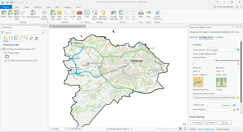
- Hit Publish, sit back and let ArcGIS Pro take care of the rest! Using my laptop on the office wifi, this took under four minutes.
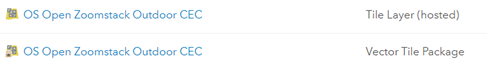
The output Vector Tile Package will automatically be uploaded and published to your active portal (ArcGIS Online/ArcGIS Enterprise).
I can now use the vector tile I published as my basemap in the ArcGIS Online map viewer.
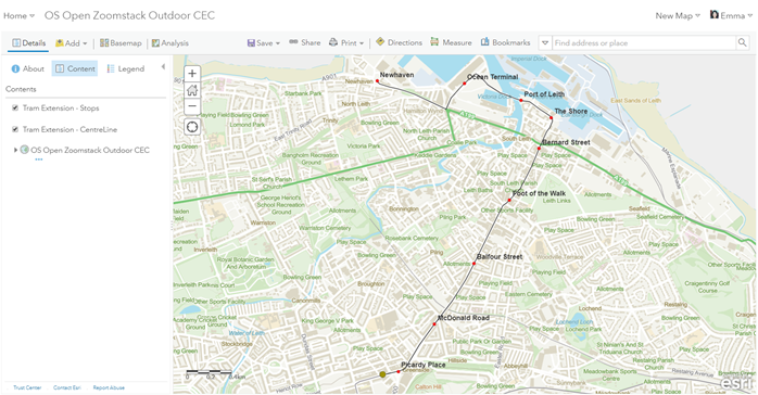
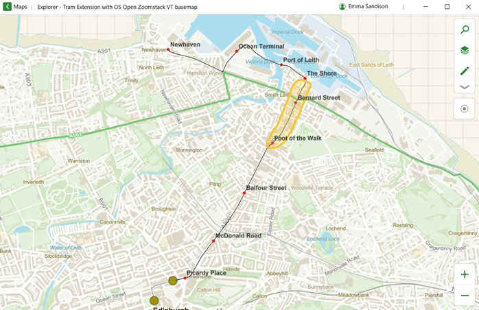
As I mentioned earlier, vector tiles are supported widely across the ArcGIS system. Below is this same web map in the Windows version of ArcGIS Explorer. I’ve then used the mark-up tool to highlight a section of road where important archaeological excavations are required during the construction work.
Using the Create Vector Tile Package Tool
An alternative way to create vector tile packages, and the method used by our team when creating the GB vector tile services, is to use the Create Vector Tile Package geoprocessing tool in ArcGIS Pro. This tool will generate a complete vector tile package, a .vtpk file, from a map or a basemap. It’s a better option if you’re working with larger data volumes. If the resulting tile package is less than 2 GB, you can upload it directly in a browser to ArcGIS Online or ArcGIS Enterprise. Otherwise, use the Share Package tool to upload it.
What’s New?
Since the 2.5 release of ArcGIS Pro, we have seen enhancements to the sharing options, improving the workflow for overwriting tile layers.
For example, you can now replace a tile layer in your ArcGIS Online portal or ArcGIS Enterprise portal (version 10.8 or later) with another tile layer, retaining an archive version. This new workflow allows you to stage and test the update layer in your portal before you replace the target layer. When the layer is replaced, user access is uninterrupted. The archive layer is available if you need to revert the update.
Want to learn more?
Caching Vector and Raster Tiles
Desktop Mapping: Creating Vector Tiles
Creating Vector Tiles in ArcGIS Pro: Web course that requires maintenance/sign in with username.