ArcGIS Pro has just dropped some amazing new features and I’m going to try my absolute hardest to outline the best ones, without being biased by the beautiful cartography additions and talking about Voxel layers the entire time.
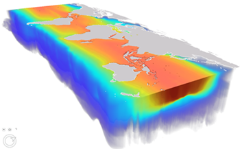
So, where do I start? Voxel layers. If Jack Dangermond can get excited about it at the Esri UC, so can I! Voxel layers are a new layer type that creates 3D volumetric visualisations, whether that’s from atmospheric or oceanic data. They create an amazing 3D visual that can be dissected and analysed to uncover new patterns you didn’t know existed. They can also be analysed over time, like in this great example. Think Minecraft, but maps… mapcraft? Let’s move on…
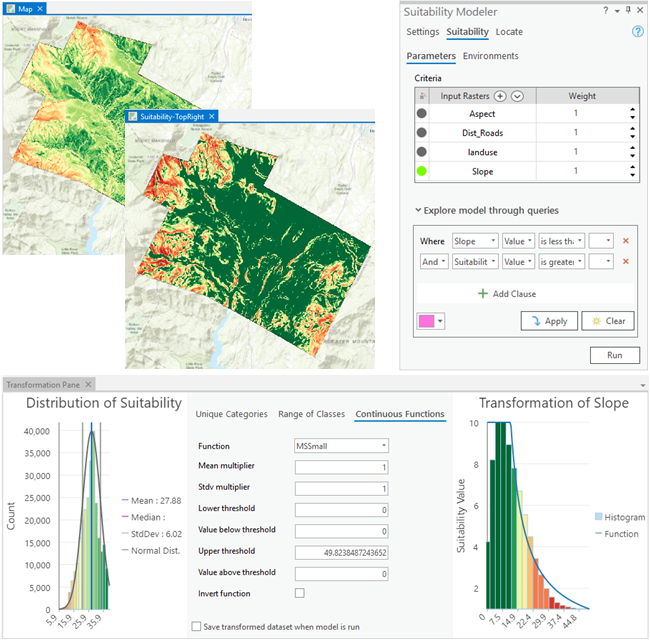
My first exposure to GIS at university was a site suitability analysis, which blew my mind at the time. Pro 2.6 introduces the Suitability Modeler that condenses all those steps into one easy tool, allowing you to explore the best location for a housing development, shopping centre or the most suitable location for growing perfect strawberries. This tool also has easy to learn steps that guide you through the process, so no more asking your lecturer for help every 5 minutes (me).
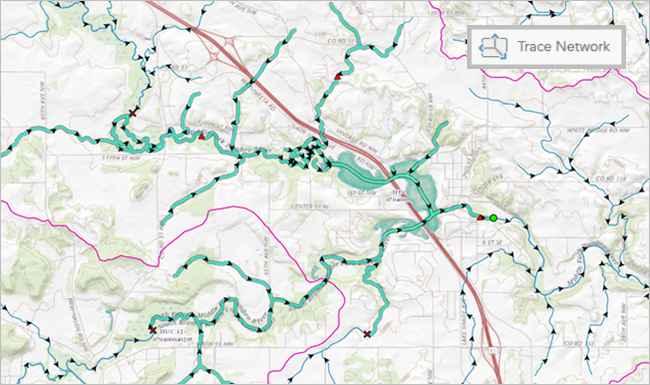
You can now manage, analyse, and work with simple connectivity models such as rail or hydro in ArcGIS Pro using the new trace network. The trace network uses a set of connected edges and junctions, along with network attributes, to model the flow of resources through the network. This new feature allows for tracing and creation of network diagrams, as well as validation to discover and address errors. Trace networks can be created using existing feature classes in a feature dataset as source junctions and edges or through direct migration from a geometric network.
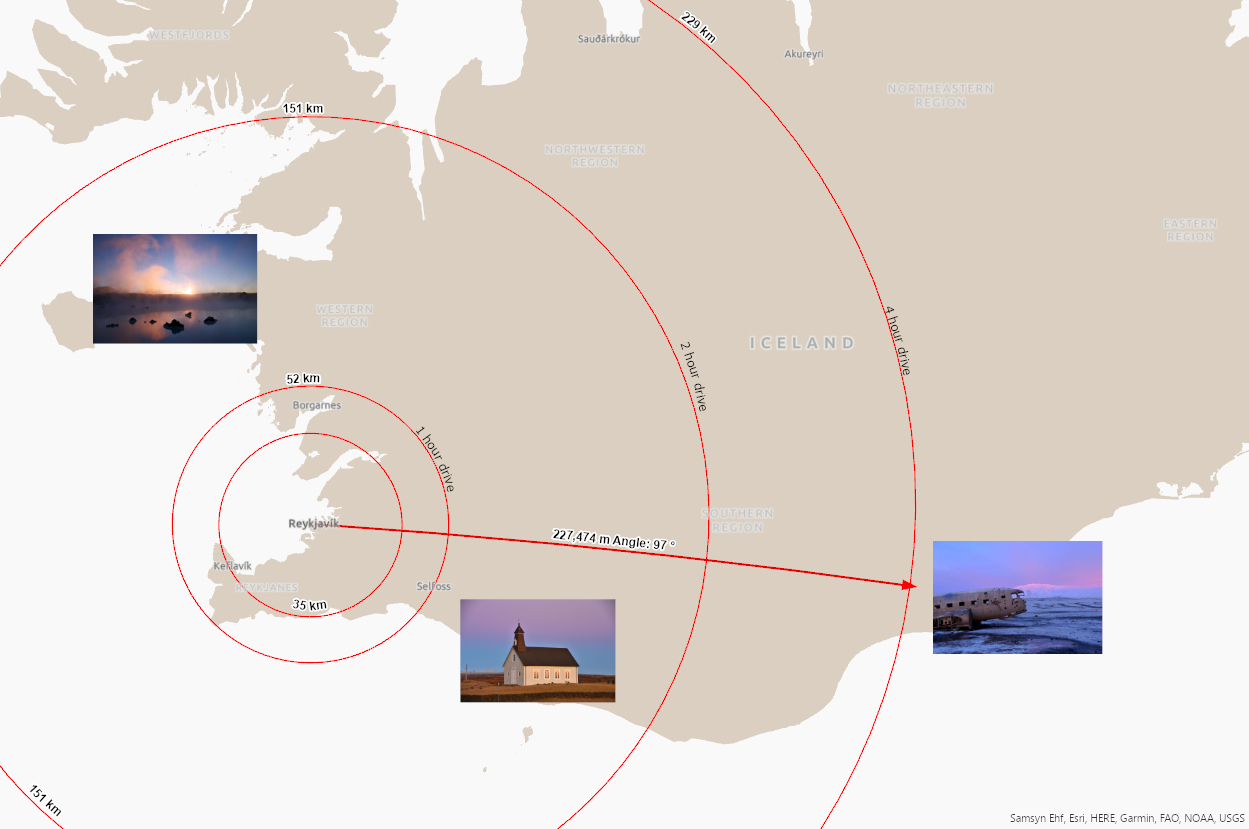
New to 2.6 is graphic layers, the ability to add graphic elements (such as points, arrows, text and pictures) to your map, with those features being spatially referenced, meaning you can maintain their position across different map extents. I’ve combined this with another new feature called Distance and Direction, which allows you to easily create rings and lines with spatial information. Perfect for your next trip to Iceland, of course!
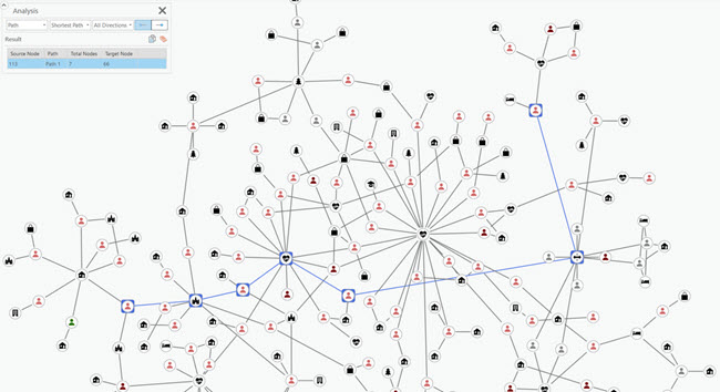
Link analysis is a new interactive capability in ArcGIS Pro that is used to discover and evaluate relationships between entities. Link charts allow transformation from feature layers to entities and relationships without complicated scripts. This allows you to visualise and find clusters of connected entities, helping you make informed decisions with considerations of their immediate network. For example, link analysis can be used in contact tracing to explore the relationships between known cases and places in impacted communities to identify high-risk areas and allocate resources. This video help explains the new feature.
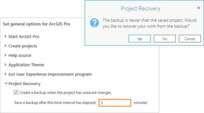
Drumroll for this one, please…. Autosave! How many times have you wanted to throw your laptop across the room because you’ve lost work? Your laptop and subsequent anger issues are now sorted thanks to the addition of ‘project recovery’, a feature that backs up your project at a defined interval.
You can now save and overwrite webmaps in Pro, which allows you to utilise the advanced cartography tools in Pro (not bias) and publish up to ArcGIS Online. To double down on my carto-excitement, bivariate choropleths are now in Pro 2.6 (they were already in Online). Feels like ArcGIS Online and Pro made a deal on this release to share features, which is nice.
A few quickfire additions to conclude:
-
ModelNuilder now has the option to delete intermediate data not used in the final output, to save some valuable space.
-
Pro 2.6 supports big data connections, allowing you to use much more data in many more ways.
-
Network Analyst now lets you add a live traffic stream from your ArcGIS Online account for further real-time analysis. You can also create Vehicle Routing Problem analysis layers too.
-
Three additional measure tools have been added for measuring in maps. Measure Direction Distance, Measure Offset, and Measure Angle allow you to compare or measure values between two or more points, or a combination of lines for offsets and angles. Ground to grid correction is available for offset and direction distance measurements.
-
Textures and colours are now read directly from the BIM file workspace. Additionally, you can now access BIM cloud connections, either accessing data directly or downloading locally before using in Pro.
-
You can configure a web imagery layer before publishing to allow users to view the underlying data.
-
A new type of map series, called a bookmark map series, generates a set of pages built from a single layout in which each page shows the map extent of a bookmark. So you can handily define your bookmarks in one map, creating a series of outputs without duplicating efforts.
I would love to carry on but with 130 GP tools added in 2.6, I’d break your tolerance of my jokes so it’s best for everyone if I stop. Go and check out the much more extensive list of new 2.6 features and and let us know if you’re equally as excited for the 2.6 update! Did I mention the voxels…?