Delivering enhanced management capability
Defence Estates has used Esri GIS technology to create a single, up-to-date view of all data pertaining to 240,000 hectares of Ministry of Defence land in the UK. With accurate information, all stored in a central repository, the organisation can make faster, better decisions and improve its land management.
The Customer
The Ministry of Defence (MOD) is one of the largest landowners in the United Kingdom, custodian of 240,000 hectares, equivalent to one per cent of the UK. Defence Estates has an annual budget of £2 billion to manage the land and its assets, balancing military requirements with social and environmental considerations. The estate includes over 45,000 military buildings, rural training grounds (30 per cent of it within National Parks), 179 Sites of Special Scientific Interest (SSSIs), 50 special protection areas, over 600 statutorily protected buildings, almost 1,000 scheduled monuments, and numerous archaeological sites. In addition, Defence Estates manages permanent overseas facilities in Germany, Cyprus, the Falkland Islands and Gibraltar, as well as resourcing military theatres such as Iraq and Afghanistan.
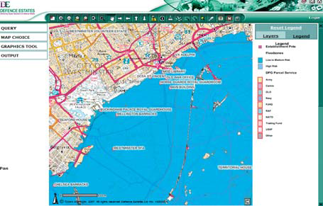
Geographic data is disseminated to users throughout the wider MOD community via desktop GIS technology and a web mapping portal
Surveyors use a GPS-enabled mobile solution to capture new data and upload it to the corporate data repository
Improved use and maintenance of third party datasets contributes to lower data management overheads
The Challenge
Defence Estates has successfully used Esri’s Geographic Information System (GIS) since 1995. However, the Strategic Defence Review (SDR) of 1998 required them to be able to query national data more effectively. A seamless and up-to-date “version of the truth” was required for both its internal and external users. This resulted in two requirements:
- Capture data in the field, ensuring the geodatabase was updated in a timely manner.
- Obtain and efficiently maintain third party datasets (from government and environmental organisations).
In addition, this data repository should be accessible to the whole organisation, with minimal instruction, not just to GIS specialists.
GIS has become a critical tool to enable strategic decision making within Defence Estates and the wider MOD community
The Solution
The Corporate Data Manager and his multi-skilled team consolidated and standardised the data captured by the eight regions. They defined and populated a spatial data model within an enterprise geodatabase that included Ordnance Survey’s baseline digital mapping. GIS applications include:
- Geographic data is disseminated via Esri’s desktop GIS viewer and Defence Estates’ web mapping portal, known as GEODE. The viewer is installed on every user’s computer, providing simple GIS to support ecologists and environmentalists working to manage activities, such as those in SSSIs. GEODE is used by the wider MOD community, with 60% of users outside Defence Estates.
- Surveyors use a GPS-enabled mobile solution to capture new data and upload it to the corporate repository. Analysts can quickly assess and communicate changes in the operational status of the estate.
- Data about historical sales and purchases of land is managed in a customised GIS called e Terrier.
Ensuring that staff understand and communicate the use and benefits of GIS is crucial to the success of the system. Over 500 staff have been formally trained in GIS by the Esri UK training team. Regular participation in the wider GIS user community is also encouraged, with regular attendance at Esri UK’s Defence Intelligence Special Interest Group (DISIG) meetings and the annual Esri International User Conference.
The Benefits
Defence Estates has realised a number of management benefits from the use of GIS:
Single, up-to-date view of data
Central data management and data repository ensures “one source and one version of the truth” for all Defence Estates’ geographic information. Users know they are looking at a valid version of the data. Consequently, the analysis they provide is accurate, consistent and current. This is particularly important for managing the land management lifecycle.
Lower costs, better resource usage
Holding a central copy of Ordnance Survey and other third party datasets has significantly reduced data management overheads. One team is now responsible for maintaining the corporate GIS data repository, freeing other GIS users for business-critical data capture, analysis, digital publication and cartographic map production.
Faster analysis
Mobile GIS enables environmentalists and surveyors to capture and maintain data in a timely manner. It can be used for immediate impact analysis, with any changes in the operational status of estate passed to the relevant departments. For example, when a nesting site for protected birds is identified, the surrounding training area must be decommissioned until the birds move on.
More informed decision making
GIS enables users to carry out analytical tasks such as the potential impact of wind farms on military activity or to advise where training trenches can be dug with minimal impact to surrounding archaeology, landscape and wildlife.
Enhanced management capability
Consolidating corporate data and metadata has resulted in the standardisation of data and skills, and defined stronger working practices. This has meant GIS, which was once perceived as a niche tool, to become a critical management decision-making resource – within Defence Estates and the wider MOD community.
The Future
Defence Estates aims to expand the functionality and range of services by using ArcGIS Server. For example, this will allow those planning training exercises and manoeuvres to determine the optimum locations, taking into account criteria such as supply depots, terrain, ground conditions, lines of sight and environmental sensitivity.
Outside the UK, one of the key challenges will be to expand the reach of the system to bases such as Germany and Gibraltar, as well as current military theatres.
Defence Estates also wants to share its GIS knowledge and experience with other business areas, so they can realise similar benefits from their geographic data.


