Blog Archives

Garsdale Design
CityEngine is transformational. We can quickly produce and amend 3D plans, delivering an efficient and top-quality service for our clients
From a converted barn in Cumbria, a small family-run design business is producing highly professional 3D urban models for the redevelopment of war-torn Iraqi cities. Thanks to the use of Esri’s CityEngine solution, Garsdale Design can quickly produce and amend 3D plans, delivering an efficient, top-quality service for its Middle Eastern clients.
The Customer
Garsdale Design is an architecture, urban design and planning firm, operating from offices in a converted barn in Cumbria. While its location may be rural, its business is undeniably global. The firm has extensive experience of undertaking urban design and city master planning assignments in the Gulf Arab states and Middle East.
The time required to produce a 3D model of a new building has been cut from four days to just half a day
The business can make last minute changes to models, very quickly, thereby meeting deadlines without having to pay outside contractors for help
The 3D models help the firm’s clients to understand what cities may look like in the future, to help make more informed planning decisions
The Challenge
Along with its Iraqi partners, Garsdale Design has been contracted by the Ministry of Municipalities and Public Works in Iraq to create urban plans for the reconstruction of several key cities in the country. This long-term project involves planning for new homes, infrastructure, transport, sewerage, water and electric systems in areas that have been seriously damaged by many years of war and neglect.
Garsdale Design recognised the importance of 3D modelling in urban planning and aspired to provide 3D visualisations of its plans to help its Iraqi clients and partners understand proposed developments. However, creating these 3D models was very time-consuming. The firm used to sketch proposed new buildings, streets and squares by hand and then digitise the pictures to create 3D images. Unsurprisingly, it used to take around four days to produce a 3D model of a single building, such as a new neighbourhood centre.
As is common in large urban redevelopments, unexpected changes were a regular occurrence. On one occasion, the location of a bridge was altered without warning, which had obvious ramifications for the planned road network and neighbouring buildings. When changes like this occurred, the firm had to throw away its out-of-date 3D models and start again from scratch – and if deadlines were tight, the firm had to make a difficult choice between not providing 3D visualisations or paying for someone else to create them.
CityEngine has expanded what we can achieve and deliver to our clients in short timescales. It helps us to keep up with bigger design companies and provide a professional service for our clients
Elliot Hartley – Director, Garsdale Design
The Solution
The discovery of Esri’s CityEngine solution has had a profound impact on the way that Garsdale Design works. 3D models have been transformed from a peripheral offering for clients into a core part of the company’s master planning process.
CityEngine is fully integrated with Esri’s ArcGIS platform and converts two-dimensional geographic information system (GIS) data into 3D models in a series of simple steps. It includes a 3D editor tool for creating realistic facades and adding vegetation and street furniture, all of which enables users to produce clear and realistic models. Despite the word ‘city’ in its name, CityEngine can be equally valuable in developing 3D models of rural landscapes, small developments and wind farms, for example.
Models or ‘scenes’ created in CityEngine can be easily published on the Internet and shared with colleagues, clients and partners. Esri’s Web Scenes viewer allows users to develop two models side by side and then employ a swipe tool to see what a development might look like, before and after.
CityEngine is transformational. It has enabled us to make dramatic time savings and, for our business, raised our ambitions so we are inspired to re-evaluate processes we took for granted
Elliot Hartley – Director, Garsdale Design
The Benefits
Through the use of CityEngine, Garsdale Design is now able to produce accurate 3D visualisations of how cities might look in the future, far more easily. These models help its clients to understand the available planning options and make better decisions to improve the lives of hundreds of thousands of city residents.
Whereas it used to take Garsdale Design around four days to create a model of just one building, the firm can now create 3D visualisations of entire city quarters in just half a day. Furthermore, when last minute changes occur or new information is received from Iraq, Garsdale Design can update its existing 3D visualisations quickly, without having to start again from scratch.
These time savings mean that Garsdale Design can now deliver a larger number of top quality, up-to-date 3D visualisations for its clients. The firm saves money by not having to pay for outside help to meet project deadlines and delivers a higher standard of service for its clients.
Elliot Hartley, director of Garsdale Design, says: “We’re a small family firm and don’t have lots of people and departments that we can draw upon when we have tight deadlines. CityEngine has expanded what we can achieve and deliver to our clients in short timescales. It helps us to keep up with bigger design companies and provide a professional service for our clients.”
In the future, Garsdale Design intends to embed rules into its 3D models, so that when data layers are added or changed, the master plan automatically updates the area. For example, if solar data is added, CityEngine could remodel a planned housing development to orientate roofs to the best angle to optimise solar energy generation.
Summing up, Hartley says: “CityEngine is transformational. It has enabled us to make dramatic time savings and, for our business, raised our ambitions so we are inspired to re-evaluate processes we took for granted. We are doing things now that we didn’t think possible before.”


Homes in Havering
Mobile GIS has halved the time required to complete property inspections, creating a more efficient process and ultimately, improved resident satisfaction
Use of a mobile GIS solution from Esri UK enables Homes in Havering to deliver more efficient and effective services for the residents of over 10,400 homes in East London. Employees use Esri’s ArcPad on tablets to halve the time required to complete property inspections, instigate maintenance tasks more quickly and improve the quality of business data.
The Customer
Homes in Havering (HiH) was formed in July 2006 as an arms-length management organisation (ALMO) working on behalf of the London Borough of Havering. It is responsible for managing 10,411 tenanted homes, 2,207 leasehold properties and 2,830 garage units in East London.
Mobile employees can undertake property inspections and other reports 50% more quickly than before
Residents benefit from faster resolution of maintenance issues, which improves their satisfaction and quality of life
ArcPad has created more efficient processes across the business and led to improvements in the quality and timeliness of business data
The Challenge
As a not-for-profit organisation, HiH aims to operate as cost efficiently as possible, reinvesting income to create homes and communities that residents can take pride in. At the time, staff carried out surveys of estates by filling in paperwork by hand, then typing them up when they got back to the office or sending them off to be manually transferred into an electronic format. “By the time that the information was available in our central systems, it was often out-of-date,” explains Roy Ojelade, Estates Services Manager at HiH. “Our processes were slow and disjointed.”
There were other challenges too. When staff went out on site, they sometimes found it hard to determine if pieces of land were the responsibility of HiH or other organisations. Consequently, it wasn’t uncommon for a lot of effort to go into dealing with issues that were not HiH’s responsibility. In addition, staff often found it hard to describe exactly where issues were on an estate. As a result, contractors and maintenance teams sometimes wasted time because they couldn’t find the locations mentioned in reports. All of these issues meant that residents didn’t always receive a prompt and effective service.
Tasks that used to take our mobile staff considerable time are now done more efficiently with any data collected being available to be disseminated among other departments within the organisation
Roy Ojelade – Estate Services Manager at Homes in Havering
The Solution
Soon after its foundation, HiH took the bold decision to extend and develop its mobile working strategy, believing this approach would improve operational efficiency, increase the visibility of staff on estates and provide a better service for residents.
Esri’s ArcPad mobile Geographic Information System (GIS) software was deployed on lightweight, portable computers to 35 employees including 12 neighbourhood wardens, 16 tenancy and neighbourhood officers, 3 senior estate managers and 4 caretakers. Through the use of ArcPad, these mobile employees can access detailed maps of each of HiH’s properties while on site and attach a precise location references to their electronic property report.
Mobile GIS is now firmly embedded into the organisation’s processes, if an area of grass has not been cut, mobile workers can see if it is the responsibility of HiH or another organisation. If a tree requires any work, they can direct the contractor straight to the exact tree at any location. Ojelade says: “We use ArcPad for just about everything, whether checking a tree for storm damage, conducting a routine estate inspection or reporting a pothole in a path.”
ArcPad helps to ensure that the data collected is geographically accurate and consistent, so it can be used for comparison and analysis. It eliminates the paper trail and improves the overall efficiency of our teams
The Benefits
More efficient business processes
The use of ArcPad has helped HiH to develop a more efficient and standardised processes, generating better data across the business. “ArcPad helps to ensure that the data collected is geographically accurate and consistent, so it can be used for comparison and analysis,” says Pluck. “It eliminates the paper trail and improves the overall efficiency of our teams.”
Time savings of at least 50%
HiH estimates that its mobile solution has reduced the amount of time required for completing inspections and other reports by at least fifty per cent. Ojelade says: “Tasks that used to take our mobile staff considerable time are now done more efficiently with any data collected being available to be disseminated among other departments within the organisation.”
Greater information sharing with residents
Caretakers use ArcPad to record the precise location where bulk rubbish, such as old mattresses and broken furniture, is found. This information is then uploaded from the mobile devices to HiH’s central systems, where it is then compiled into monthly reports and published online. “The data collected allows us to re-charge residents for bulk rubbish with precise information about what has been dumped and where,” explains Ojelade. “ArcPad provides a fast and accurate way for us to collect this information.”
Improved maintenance of properties
Mobile teams can quickly report faults and issues which means these problems can be rectified more quickly too. Likewise, staff can identify where contractors are failing to meet standards and point out areas that need greater attention with more precision. The use of ArcPad has enabled HiH mobile working strategy, delivering a more streamlined process in the overall maintenance of HiH’s estates and to a corresponding improvement in resident satisfaction.

Manchester Airport Group
By analysing patterns of movement around the airport we can understand the changing needs of our customers and target resources appropriately
The enterprise-wide use of Esri’s ArcGIS platform has brought clarity to complex operational, environmental and strategic issues at Manchester Airport (MAG). The solution has helped the organisation to optimise retail profitability, improve the efficiency of its workforce and make better decisions about the future development of the UK’s third busiest airport.
The Customer
Manchester Airports Group (MAG) owns and operates four British airports: Manchester, London Stansted, East Midlands and Bournemouth. As the largest UK-owned airport business, it serves around 42 million passengers every year and supports more than 130,000 jobs.
MAG used ArcGIS to analyse patterns of movement around the airport and optimise office locations to improve the efficiency of its workforce
ArcGIS was used to analyse passenger footfall in retail areas and increase revenues from retail units, while decreasing marketing costs
Engineers use ArcGIS to better plan maintenance activities so as to minimise disruption to flights and passengers
The Challenge
Known as ‘the global gateway to the North of England’, Manchester Airport is the largest of MAG’s four regional airports. MAG wanted to increase the profitability of this successful passenger and freight transportation hub, by maximising its retail revenues, improving its marketing to new and existing customers and optimising its efficiency across all areas of the business.
In any organisation, these would be ambitious goals. In a complex business like Manchester Airport, however, the challenges are multiplied. As well as developing its business, MAG must simultaneously address a multitude of other issues including environmental legislation, aviation safety, airport security and the sensitivities of local residents.
ArcGIS has been instrumental in helping MAG minimise its impact on the environment, improve its customer service and develop positive community relations
The Solution
Geographic information system (GIS) technology was first used at Manchester Airport nearly 20 years ago, when it was employed to model noise contours. Following early success with the technology, the use of GIS steadily expanded and, today, it is a vital spatial information management and business analysis system, employed to great effect throughout the entire organisation. MAG’s enterprise GIS platform is based on Esri’s ArcGIS technology and encompasses server, desktop and mobile applications.
Our use of GIS helped us create a more efficient workforce
Vickie Withnell – Group GIS Advisor, MAG
The Benefits
ArcGIS brings clarity to complex operational, environmental and strategic issues and, over recent years, has played a pivotal role in helping MAG make important decisions about the development of Manchester Airport. The solution has identified opportunities to improve business efficiency and hence reduce costs, as well as revealed new ways to optimise profitability. ArcGIS has also been instrumental in helping MAG minimise its impact on the environment, improve its customer service and develop positive community relations.
Here are just a few examples of how GIS has added immeasurable value for MAG.
In one very successful initiative, the organisation employed GIS to analyse the locations of its assets at Manchester Airport vis-à-vis the locations of the people who use those assets on a daily basis. It then relocated teams to site them in better facilities in more convenient areas, where they would spend less time travelling to and from jobs. “Our use of GIS helped us create a more efficient workforce,” says Vickie Withnell, Group GIS Advisor at MAG. “At the same time, we managed to free up office space that could be allocated to commercial, thereby improving our profitability.”
During the renovation of its departure areas, MAG employed GIS to model the new retail spaces created and demonstrate passenger flow through these areas. With this valuable insight, the retail team could identify the retail units with the highest ‘footfall’ and market these premium units to higher-end retailers. MAG was able to optimise its retail revenues, as well as make cost savings by re-using the GIS visualisations for brochure illustrations.
Engineers at MAG use a mobile GIS application to log faults and request maintenance work while out and about on site. MAG then analyses this information and uses it to plan work strategically, taking into account aircraft departure and arrival times. “We can now schedule work to suit the business and minimise disruption to our airline customers at busy times,” Withnell says.
To improve the customer experience, MAG used GIS to visualise and analyse customer locations, socio-demographic groups, methods of travel to the airport, road and rail networks and car parking facilities. With this information, it could then target its marketing more precisely, sending information about train stations to potential customers in the areas where people most commonly travel via train and sending information about the most conveniently-located car parks to the people who travel by car. MAG saved money on its marketing, while delivering relevant information to customers that will improve the quality of their visit to the airport.
MAG’s community relations team used GIS to analyse flight paths, noise contours and residential areas and identify the individual properties that qualified for funding for secondary double glazing under the Sound Insulation Grant Scheme. “It was a positive exercise in community relations that resulted in over 2,000 grants being awarded to local people,” Withnell says.
Building on its many successes, MAG is now developing a new GIS, based on ArcGIS, to help it undertake long term asset planning. This advanced solution will simplify the entire asset management lifecycle and play a critical role in helping to shape the future growth of the organisation.

Energy Saving Trust
Our analysis of 27 million UK homes, is used to help government and commercial organisations implement energy saving schemes at more properties
In a highly ambitious project, the Energy Saving Trust used Esri GIS technology to consolidate and analyse data on all 27 million homes in the UK. It gained a unique understanding of the energy efficiency status of every individual address and is now using this insight to help governments and commercial organisations implement energy saving schemes at more properties, more cost effectively than before.
The Customer
Passionate about improving energy efficiency in the UK, the Energy Saving Trust advises individuals and households on the best ways to reduce energy bills, conserve water and minimise carbon emissions. It also works with government, local authorities and commercial organisations to help them improve the effectiveness of their sustainable energy programmes.
The Energy Saving Trust integrated GIS with its existing IBM Cognos BI system to identify properties most likely to benefit from green energy initiatives
Local councils, energy companies and commercial organisations can now reduce their marketing costs and improve the success of their schemes, by targeting only qualifying properties
Local authorities in Scotland use the GIS portal to identify homes potentially affected by fuel poverty and put measures in place to alleviate suffering
The Challenge
Across the UK there are in excess of 27 million homes, a large proportion of which were built long before the availability of modern insulation materials, efficient heating appliances and domestic energy generation systems. If the owners of these properties were to retrofit loft or cavity insulation, upgrade their boilers or install solar panels, for example, they could not only lower their energy bills, but also reduce carbon emissions, benefitting the environment as a whole.
Many different organisations – from central government and local authorities to energy suppliers – are actively engaged in promoting energy efficiency measures to home owners. However, the Energy Saving Trust observed that these energy campaigns were rarely informed by an accurate understanding of the types of homes prevalent in specific locations and the best measures to install in each home. Consequently, information about solar panels was frequently mass marketed to all homes in an area, rather than to selected homes with south facing roofs, for example.
This problem stemmed from two specific challenges: firstly there was no single database of accurate home data, covering all of the UK; and secondly the limited amount of data that was available was not easily accessible to the people on the ground, who were implementing energy saving programmes. “Decisions frequently weren’t based on evidence, which can lead to the inefficient delivery of programmes, increased costs and, in some cases, unwarranted hassle for consumers,” comments Will Rivers, data insight manager at the Energy Saving Trust.
In some cases, as much as two thirds of the cost of delivering an energy efficiency scheme can be attributed to identifying and locating the right types of home. By reducing this cost of delivery, we can help organisations to deliver more energy saving measures into the UK housing stock in a more cost effective way
Will Rivers – data insight manager at the Energy Saving Trust
The Solution
The Energy Saving Trust set about consolidating data on every home in the UK, including property type, size, age, wall construction, loft insulation, glazing, tenure and the sociodemographic profile of the householder. Then, the organisation used geographic information system (GIS) technology from Esri UK to work out the likely roof orientation of each property and its suitability for solar panels; measure the distance of each home from mains gas and supplies of biomass fuel; and analyse the potential for wind-energy. Through this sophisticated use of GIS, the Energy Saving Trust gained valuable knowledge about every single home in the UK and successfully built up a comprehensive database with energy-related data never captured before.
“Esri technology in combination with Ordnance Survey data has enabled us to target the installation of a number of sustainable energy technologies in a far more accurate way so that we can work to increase take up of these measures,” Rivers says.
In addition, the Energy Saving Trust engaged Esri UK’s partner Assimil8 to integrate GIS into its existing IBM business intelligence system using Esri Maps for IBM Cognos. With this GIS portal, called Home Analytics, the organisation and its many partners can now perform complex searches to find, for example, houses over a certain age, in a specific city, with unfilled walls and occupants on low income, to identify precisely those households that might qualify for funding for insulation. They can generate displays on a digital map, make selections and export a report with a list of just those qualifying addresses.
Esri technology in combination with Ordnance Survey data has enabled us to target the installation of a number of sustainable energy technologies in a far more accurate way so that we can work to increase take up of these measures
Will Rivers – data insight manager at the Energy Saving Trust
The Benefits
The Energy Saving Trust’s Home Analytics solution enables organisations to target the right homes and the right people with the most appropriate energy efficiency schemes. It is therefore playing a crucial role in the UK, helping to drive the adoption of measures to reduce energy consumption, minimise carbon emissions and alleviate fuel poverty.
Local authorities use Home Analytics to help them reduce the cost of implementing energy efficiency initiatives and improve their ability to meet government targets. Rather than knocking on every door in a neighbourhood or mailshotting an entire city, councils can focus their resources on precisely those homes that meet the criteria. “In some cases, as much as two thirds of the cost of delivering an energy efficiency scheme can be attributed to identifying and locating the right types of home,” Rivers explains. “By reducing this cost of delivery, we can help organisations to deliver more energy saving measures into the UK housing stock in a more cost effective way.”
Commercial companies, like solar panel providers, can also take advantage of Home Analytics to improve their sales success and install more solar panels – both improving their revenues and helping to reduce the country’s overall carbon emissions. Equally, the UK’s large energy suppliers can use the solution to target those households where they can achieve the biggest reduction in carbon for the least cost. “If we can help energy companies deliver their energy obligations more cheaply, we can make their investment go further and improve the success of government policies like the Green Deal,” Rivers says.
Millions of people across the UK are affected by fuel poverty, and Home Analytics can be used to help to alleviate this suffering. Local authorities in Scotland currently use this GIS portal to pinpoint those homes in specific locations, occupied by people over 75 or under 5 years old, with high energy bills and low incomes and no cavity wall insulation for example. “Fuel bills have more than doubled since 2005,” says Rivers. “Home Analytics helps local authorities identify people who are at most risk and provide targeted support.”
Bournemouth University
In recognition of the growing importance of GIS in many careers, students of subjects including biology and forensic science will learn valuable GIS skills
The Applied Sciences School of Bournemouth University is breaking new ground by incorporating GIS training into many more of its courses. For the first time, students of subjects including biology and forensic science will learn valuable GIS skills alongside students of geography and ecology, in recognition of the growing importance of GIS in many careers.
The Customer
As one of the six schools within Bournemouth University, Applied Sciences contains three academic centres. One focuses on archaeology, anthropology and heritage, another covers ecology and geographical science while the third deals with forensic science. Teaching both undergraduate and postgraduate courses, the school has an International reputation for delivering high quality education while also pursuing excellence in research. Areas of research expertise include: Forensic archaeology and crime scene science where, for example, staff are currently investigating genocide in Iraq, Bosnia and Rwanda and the implications of unearthing 40,000 year old human footprints in central Mexico.
The university has been able to take advantage of an educational licensing agreement with Esri UK to expand its teaching of GIS cost-effectively
Forensic science students now use Esri’s ArcGIS to identify where snipers might hide and where murderers might conceal bodies
Many more science students will leave university with a practical knowledge of using GIS, adding to their employability skills
The Challenge
In the past, only Ecology and Geography undergraduates were taught GIS for all three years as undergraduates, while Archaeologists attended GIS lectures in their third year. Recently, Forensic Science students also joined the GIS sessions from their second year onwards and other disciplines are soon to follow suit. Biology will be the next subject to take advantage of learning GIS skills from the second year on, for example.
Andy Ford, Lecturer in Geoinformatics, explained: “The growing relevance of GIS in various industries means it’s becoming ever more applicable to other subjects here at Bournemouth. Our aspiration is to make GIS available to all students within the school, giving them the benefit of learning new skills which are now in demand in the workplace. This means GIS will be accessible for Environmental Sciences and Biology students – in addition to those studying Archaeology, Geography; Forensic Science and Ecology.”
Our aspiration is to make GIS available to all students within the school, giving them the benefit of learning new skills which are now in demand in the workplace
Andy Ford – Lecturer in Geo informatics
The Solution
The main driver behind the new GIS initiative is that it can easily be applied to the various disciplines, to help solve relevant challenges and tasks and Bournemouth therefore believes it should be taught, to a wider audience.
The school is also set to benefit from greater economies of scale, as students from all disciplines will attend the same GIS sessions, rather than additional tailored modules which would not be economically viable. This gives staff more time to devote to research and generate the valuable income all universities need for long-term growth.
Bournemouth uses a mix of GIS software as part of its teaching programme, including Esri ArcInfo and ArcView. The campus-wide Esri licence acquired via the Eduserv CHEST programme supports the spread of GIS to new subjects, as it allows an unlimited number of users at no additional cost.
GIS is the glue that holds all the disciplines together, or will be in the future. We’ll be teaching GIS to all three centres for all three years
Andy Ford – Lecturer in Geo informatics
The Benefits
Bournemouth’s GIS teaching is already breaking new ground in the field of Forensic Science, where the capabilities of GIS are being realised for the first time. A prime example involves current Masters students, using Esri ArcView to create predictive models to help identify dump sites for murder victims.
Examining a range of spatial criteria, the models help users consider the type of decisions murderers make when hiding a body. This normally involves a thought process to find the right kind of landscape and vegetation, not too far from a road or car park and walking downhill rather than uphill. Using GIS, students create the different data layers and are able to understand all the different factors in context, to quickly reduce the area to be searched for a body.
Future plans for GIS-Forensics include students evaluating the vulnerability of 2012 Olympic sites to sniper fire, in a similar way in which proximity and viewsheds were used to identify the sniper’s locations in the Beltway shooting in Washington DC, which led to the individual’s capture.
The main benefit from increased exposure to GIS: The new skills being gained. “Graduates will be more employable and can consider jobs which specifically involve GIS. In Forensics for example, they will be able to apply emerging techniques which are relatively new to their discipline. In Europe this area of science is not as mature as in the US and is currently a growth area.” explains Ford.
Increasing the number of students being taught GIS across the School of Applied Sciences is no easy task but the benefits of students developing critical thinking skills through spatial analysis, outweighs any initial logistical challenge for Bournemouth. “As more students start to understand the concepts and potential power and utility of GIS, so other areas of science and industry will benefit. Soon there’ll be a lot more Biologists, Archaeologists Forensic Scientists or Geologists – not just Geographers – able to apply the power of spatial analysis in the real world,” concluded Ford.

The Crown Estate
ArcGIS is used to model complex scenarios, helping us to make important decisions that balance the needs of the environment against plans to maximise revenues.
Responsible for a multi-billion pound portfolio of land, the Crown Estate has to make important decisions that balance the needs of the environment against plans to maximise revenues.
Its use of Esri’s ArcGIS platform enables it to undertake faster modelling of complex scenarios, enabling it to save £135,000 in staff costs in six months alone.
The Customer
The Crown Estate manages a multi-billion pound portfolio across the UK: urban, rural, Windsor and marine estates. It has a duty to enhance their value, minimise environmental impact, maximise revenue and give profit to the Treasury.
Marine assets include around half the foreshore, half the beds of estuaries and tidal rivers, and almost the entire seabed out to 12 nautical miles – almost three times the area of Great Britain, and including 22,000 km of coastline. It controls the rights to explore and utilise natural resources of the continental shelf (excluding oil, gas and coal), granting leases or licences for ports and harbours, conservation, offshore renewables (wind, wave and tidal), aggregate dredging, pipelines/cables, and aquaculture. Over the last decade, revenue has grown 70%, delivering £1.8bn profit.
ArcGIS is used to map existing demand and the future potential of marine estates, providing valuable insight to support decision making
The Crown Estate recognises that it has saved time and money in highlighting the potential for off-shore wind farm development
GIS analysis allows the organisation to see potential conflicts between activities, and help to identify the optimum compromises
The Challenge
The Crown Estate needed advanced knowledge management and decision support systems to analyse and manage increasingly complex marine activities and balance diverse interests of stakeholders. Most of the data had a locational element, and the number and type of parameters involved were unparalleled, so a geographic information system (GIS) was key. The challenge was to build a toolset to analyse multiple datasets. “We needed a more comprehensive understanding of the value of our marine estate in order to manage its future to the best of our ability”, explained Peter Lawrence, MaRS Programme Manager.
Esri had the scalability and openness we needed to build what is one of the most comprehensive, integrated GIS data sources that the UK now possesses
Peter Lawrence – MaRS Programme Manager
The Solution
The Crown Estate invested almost £4m to create a sophisticated GIS analysis tool, Marine Resource System (MaRS), using ArcGIS to build a spatial database of every national dataset (currently 450). “Esri had the scalability and openness we needed to build what is one of the most comprehensive, integrated GIS data sources that the UK now possesses”, commented Lawrence. A desktop GIS tool for non-specialists was next: users connect to the spatial database, select data layers, view associated policies, and select inputs or constraints to do multi-criteria analysis.
MaRS is used to map existing demand and future potential of marine estates, helping pick areas to develop, while mitigating conflicting interests. “MaRS is a sophisticated decision-support tool which automates our constraint analysis. The results help us decide if building a wind farm is more suitable and sustainable than dredging for sand, for example, and what the monetary value is”, said Lawrence. “The resulting map is supported by the policies, rules and data analysed and used within the Estate’s business planning to make sure an activity fits our overall business strategy.”
The result is a sustainable plan that exists in space and time – we don’t think so many variables have been brought together for this type of analysis anywhere else in the world
Peter Lawrence – MaRS Programme Manager
The Benefits
The Crown Estate can better manage its marine estate in several ways:
Ensuring future energy supplies
The UK is the world’s largest producer of offshore wind energy, and wind is the fastest growing renewable – but more is needed. EU targets require 15% of the region’s energy from renewables by 2020, and UK government targets require an 80% reduction from 1990 levels of carbon emissions by 2050. “MaRS has helped de-risk the investment opportunity for international wind farm developers and has saved at least a year and millions of pounds… The information we now have available from MaRS helps show how the UK is one of the most attractive prospects for offshore wind development that exists today – great for both our economy and providing us with new sources of energy”, said Lawrence.
Balancing conflicting interests
“As more activities compete for the same space, MaRS analysis will be vital to help assess both short-term demands and long-term considerations”, Lawrence explains. For example, building an oil pipeline over an area licensed for aggregate dredging would have lost dredging revenue of almost £120m. Using MaRS, a compromise was implemented, safeguarding revenues.
Operational efficiency
A typical model to analyse consent issues has 90-120 data layers, and the analysis over 400 separate geo-processing steps. MaRS automates this, saving an estimated hour per layer, allowing the team to run models simultaneously or in quick succession. This saved over 300 days in six months, equating to £135,000 in staff costs.
New markets
“Ideally MaRS will become a global product to help establish best practice in cross-border marine resource planning. This would make collaboration and co-operation easier on joint initiatives, such as super grids or carbon capture”, said Lawrence. “Esri has helped us create a system which streamlines the complex GIS analysis of our marine assets, improving our ability to plan and direct our business. Being able to assess what’s best for our economy, the population and environment is of paramount importance both for today and for future generations”, concluded Lawrence.

Defence Estates
GIS is used to manage 240,000 hectares of land and has become a critical tool to enable strategic decision making across the wider MOD community
Defence Estates has used Esri GIS technology to create a single, up-to-date view of all data pertaining to 240,000 hectares of Ministry of Defence land in the UK. With accurate information, all stored in a central repository, the organisation can make faster, better decisions and improve its land management.
The Customer
The Ministry of Defence (MOD) is one of the largest landowners in the United Kingdom, custodian of 240,000 hectares, equivalent to one per cent of the UK. Defence Estates has an annual budget of £2 billion to manage the land and its assets, balancing military requirements with social and environmental considerations. The estate includes over 45,000 military buildings, rural training grounds (30 per cent of it within National Parks), 179 Sites of Special Scientific Interest (SSSIs), 50 special protection areas, over 600 statutorily protected buildings, almost 1,000 scheduled monuments, and numerous archaeological sites. In addition, Defence Estates manages permanent overseas facilities in Germany, Cyprus, the Falkland Islands and Gibraltar, as well as resourcing military theatres such as Iraq and Afghanistan.
Geographic data is disseminated to users throughout the wider MOD community via desktop GIS technology and a web mapping portal
Surveyors use a GPS-enabled mobile solution to capture new data and upload it to the corporate data repository
Improved use and maintenance of third party datasets contributes to lower data management overheads
The Challenge
Defence Estates has successfully used Esri’s Geographic Information System (GIS) since 1995. However, the Strategic Defence Review (SDR) of 1998 required them to be able to query national data more effectively. A seamless and up-to-date “version of the truth” was required for both its internal and external users. This resulted in two requirements:
- Capture data in the field, ensuring the geodatabase was updated in a timely manner.
- Obtain and efficiently maintain third party datasets (from government and environmental organisations).
In addition, this data repository should be accessible to the whole organisation, with minimal instruction, not just to GIS specialists.
GIS has become a critical tool to enable strategic decision making within Defence Estates and the wider MOD community
The Solution
The Corporate Data Manager and his multi-skilled team consolidated and standardised the data captured by the eight regions. They defined and populated a spatial data model within an enterprise geodatabase that included Ordnance Survey’s baseline digital mapping. GIS applications include:
- Geographic data is disseminated via Esri’s desktop GIS viewer and Defence Estates’ web mapping portal, known as GEODE. The viewer is installed on every user’s computer, providing simple GIS to support ecologists and environmentalists working to manage activities, such as those in SSSIs. GEODE is used by the wider MOD community, with 60% of users outside Defence Estates.
- Surveyors use a GPS-enabled mobile solution to capture new data and upload it to the corporate repository. Analysts can quickly assess and communicate changes in the operational status of the estate.
- Data about historical sales and purchases of land is managed in a customised GIS called e Terrier.
Ensuring that staff understand and communicate the use and benefits of GIS is crucial to the success of the system. Over 500 staff have been formally trained in GIS by the Esri UK training team. Regular participation in the wider GIS user community is also encouraged, with regular attendance at Esri UK’s Defence Intelligence Special Interest Group (DISIG) meetings and the annual Esri International User Conference.

A Defence Estate Safeguarding Plan; Using GIS to help facilitate Town and Country Planning in the vicinity of military complexes
The Benefits
Defence Estates has realised a number of management benefits from the use of GIS:
Single, up-to-date view of data
Central data management and data repository ensures “one source and one version of the truth” for all Defence Estates’ geographic information. Users know they are looking at a valid version of the data. Consequently, the analysis they provide is accurate, consistent and current. This is particularly important for managing the land management lifecycle.
Lower costs, better resource usage
Holding a central copy of Ordnance Survey and other third party datasets has significantly reduced data management overheads. One team is now responsible for maintaining the corporate GIS data repository, freeing other GIS users for business-critical data capture, analysis, digital publication and cartographic map production.
Faster analysis
Mobile GIS enables environmentalists and surveyors to capture and maintain data in a timely manner. It can be used for immediate impact analysis, with any changes in the operational status of estate passed to the relevant departments. For example, when a nesting site for protected birds is identified, the surrounding training area must be decommissioned until the birds move on.
More informed decision making
GIS enables users to carry out analytical tasks such as the potential impact of wind farms on military activity or to advise where training trenches can be dug with minimal impact to surrounding archaeology, landscape and wildlife.
Enhanced management capability
Consolidating corporate data and metadata has resulted in the standardisation of data and skills, and defined stronger working practices. This has meant GIS, which was once perceived as a niche tool, to become a critical management decision-making resource – within Defence Estates and the wider MOD community.

Magnetometer survey can also reveal archaeological evidence. This image is believed to be a British-Romano settlement.
The Future
Defence Estates aims to expand the functionality and range of services by using ArcGIS Server. For example, this will allow those planning training exercises and manoeuvres to determine the optimum locations, taking into account criteria such as supply depots, terrain, ground conditions, lines of sight and environmental sensitivity.
Outside the UK, one of the key challenges will be to expand the reach of the system to bases such as Germany and Gibraltar, as well as current military theatres.
Defence Estates also wants to share its GIS knowledge and experience with other business areas, so they can realise similar benefits from their geographic data.

Dŵr Cymru Welsh Water
Our enterprise-wide GIS approach has led to wide-ranging efficiency gains, improved customer service and lowered IT maintenance costs.
Compelled to meet tough Ofwat targets, Welsh Water implemented Esri’s ArcGIS Server and UtilityView solutions to deliver new and improved capabilities to both mobile and office-based employees. This enterprise-wide GIS approach has led to wide-ranging efficiency gains, improved customer service, more strategic asset management and lower IT maintenance costs.
The Customer
Welsh Water is owned by Glas Cymru, a not-for-profit company. It provides drinking water and sanitation services to more than three million people in Wales, and some adjoining areas of England.
Replacing multiple fragmented GIS systems with a single Esri platform has reduced ongoing IT maintenance and management costs, giving the organisation a lower total cost of ownership
Integrated with SAP systems, ArcGIS allows Welsh Water to monitor the condition of assets, analyse fault histories and plan capital investments more strategically to improve customer service
ArcGIS has reduced the time required for risk analysis from five hours to ten minutes
The Challenge
In November 2009, the water regulator OFWAT set tight controls over the prices that Welsh Water could charge customers. OFWAT also stipulated that the utility company must cut operating costs by one fifth to improve efficiency and enable the average household bill to fall by £30 before inflation. In a press release issued in February 2010, Welsh Water admitted that these were “the toughest efficiency targets” it had ever faced.
Welsh Water needed to consolidate its network and asset-related data, making it readily accessible to all of its 1,800 employees. In its vision for the future, everyone would be able to access precisely the information they needed to do their jobs – whether they were speaking to customers from a call centre, modelling the requirements for a new housing estate, or surveying a burst pipe in a remote village.
We wanted to create a single,enterprise GIS that would present a clear view of our assets and then take this information right out to the sharp end
Kelvin Davies – ICT Change Manager at Welsh Water
The Solution
Welsh Water launched a wide-ranging programme of IT-enabled change, upgrading its Geographic Information System (GIS) technology as a key part of this programme. As part of its business transformation, Welsh Water decided to develop a more consistent, enterprise-wide approach that would enable it to exploit its location-based data across the organisation.
Kelvin Davies, ICT Change Manager at Welsh Water, saw a real opportunity for the business. He says: “We wanted to create a single, enterprise GIS that would present a clear view of our assets – and then take this information right out to the sharp end.” At Welsh Water, ‘the sharp end’ is what matters most. It is where customer service agents interact directly with customers and where mobile engineers interact directly with the company’s assets to survey, repair and replace them.
Welsh Water replaced three disparate legacy GIS applications with a single platform from Esri UK based on ArcGIS Server. This provided a master database for all of the organisation’s spatial data. Welsh Water deployed a utility-specific web application from Esri UK called UtilityView; allowing network maps to be easily accessed internally for office workers, and also remotely and securely for mobile engineers and partners.
Welsh Water also integrates ArcGIS with SAP business applications to create streamlined business workflows. Every notification raised in SAP against a property or an asset, is now spatially referenced.
Welsh Water can run reports in SAP to identify its worst performing assets and map them in ArcGIS to expose patterns. When ArcGIS reveals trends, such as a stretch of water main that bursts regularly, plans can be made to replace it as part of the company’s capital investment programme, ensuring that it focuses its money on precisely the areas of its network that need it most.
Previously, it would take two hours to create a typical water quality drawing, but now the new system can produce ten in the same time. To identify above and below ground assets at risk of flooding might have taken five hours, but it can now be done in less than ten minutes
Gareth Paske – Asset Strategy Team Member at Welsh Water
The Benefits
Using Esri technology and Esri UK solutions, Welsh Water has succeeded in making GIS capabilities more accessible and relevant to all of its 1,800 employees and 900 users at various external organisations, realising efficiency improvements right across its business. These improvements range from mobile workers accessing GIS on Toughbook computers to reduce the duration of roadwork disruption and costs; through to improved safety when excavating by accessing electricity networks from partners straightaway.
Cost savings are also being made through faster network modelling using ArcGIS Desktop solutions to analyse information and identify current and future asset investment requirements. Gareth Paske from the Asset Strategy Team was one of the first employees at Welsh Water to use the new enterprise GIS. Commenting on the solution, he says: “Previously, it would take two hours to create a typical water quality drawing, but now the new system can produce ten in the same time. To identify above and below ground assets at risk of flooding might have taken five hours, but it can now be done in less than ten minutes.”
Welsh Water also recognises that its new enterprise GIS has a lower ongoing cost of ownership than its previous fragmented systems and that efficiency gains are sustainable because GIS-related maintenance costs have fallen. “There is a big difference between what the company is expending now to maintain its GIS, compared with what it used to expend,” says Davies.
There is a big difference between what the company is expending now to maintain its GIS, compared with what it used to expend
Kelvin Davies – ICT Change Manager at Welsh Water
The Future
GIS now plays a greater role in disaster planning and helps Welsh Water to understand and manage business risk. If there is a failure at a service reservoir or a contamination, the organisation can assess the impact of that failure more quickly and identify customers affected.

Cheshire, Warrington and Halton Info Consortium
Our partners upload their data into ArcGIS once and make it available for everyone to analyse and share crime prevention strategies.
This public service partnership, comprising local councils, police and fire services, uses Esri’s ArcGIS platform to share facts about criminal activities and anti-social behaviour. With easy access to up-to-date information and improved data analysis capabilities, the partners are saving an estimated £20,000 a year, while also combating crime more effectively.
The Customer
The Cheshire, Warrington and Halton Information Consortium (CWHIC) is a public service partnership formed to deliver customer facing services across the region and promote data sharing between members. Partners include Cheshire County Council, Chester City Council, seven borough councils, Cheshire Police, and Cheshire Fire and Rescue Service.
ArcGIS analyses data from multiple sources, allowing detailed fortnightly tactical assessments to be produced more quickly and cost effectively than before
Partners save time as they no longer have to distribute their data to different parties; they simply upload it to ArcGIS once for everyone to view
The GIS solution provides new insight into crime and anti-social behaviour, which partners use to inform crime prevention and detection strategies, helping to protect citizens
The Challenge
Crime and anti-social behaviour affect agencies and groups including hospitals, councils, and police, as well as citizens. However, when one sought information from another, it could take days or weeks to arrive, and effort was sometimes duplicated, supplying the same information to different groups.
Phil Christian, a former police intelligence analyst, was seconded to Cheshire County Council to help the consortium build and implement its information strategy. He explains, “CWHIC wanted to create a central information hub to make up-to-date information more accessible to a range of different partners.”
Although it is a large organisation, Esri UK is always willing to engage with us on a one-to-one basis and help however it can
Phil Christian – Project Lead, seconded to Cheshire County Council
The Solution
The initial plan was a central database for sharing partners’ data. However, Christian had experience of Geographic Information Systems (GIS) and recognised that most of the data had a location element. He convinced his colleagues of the advantages and added value that GIS would bring.
The consortium eventually chose a system developed by Cheshire County Council’s GIS Team, using an ArcGIS Server corporate, intranet-based system. “It is particularly intuitive to use”, says Christian. “Partners don’t need to know how functions work to be able to get value from using them. When they zoom in, ArcGIS automatically recalculates the crime totals for each different layer.”
The Community Safety Targeting Resources information hub (CO-STAR for short) was implemented in just three months, without needing specialist external consultants, though Christian values the council’s relationship with Esri UK: “Although it is a large organisation, Esri UK is always willing to engage with us on a one-to-one basis and help however it can.” CO-STAR currently includes data from the county council, police, fire and rescue service, ambulance service and four district hospitals, as well as Mosaic population profiling data and the Vulnerable Localities Index. Each partner can upload its latest data directly over the internet, minimising central data administration and ensuring that the system remains up-to-date.
Partners can select data on crime, injuries and arson, for example, and layer this on a map. They can then use drop-down boxes to view incidents on a specific date, within a certain time period or by different boundaries, and either display a map of the entire region or zoom in to street level. In most instances, partners can access the information that they need in no more than four mouse clicks.
Because CO-STAR uses pre-defined problem scenarios, users see data in a consistent format, reducing the likelihood of inaccurate interpretation. “You don’t have to be an expert in GIS to be able to access and use the system”, says Christian. “It brings the power of an Esri desktop solution to those who didn’t have access to it. It’s a very powerful, but incredibly friendly tool.”
Now, the data analysts can use CO-STAR to do it all with a few clicks of a mouse… We estimate that we will achieve savings of £20,000 per year from this use of CO-STAR alone
Phil Christian – Project Lead, seconded to Cheshire County Council
The Benefits
Partners immediately noticed time and efficiency savings: they only supply their data once, and can quickly and easily access the latest data from any of the others. This makes the fortnightly tactical assessments much easier to produce and avoids consulting numerous spreadsheets and making separate data queries. “Now, the data analysts can use COSTAR to do it all and they can find the information that they need in just a few clicks of the mouse. We estimate that we will achieve savings of £20,000 per year from this use of COSTAR alone”, explains Christian.
However, the most important advantage is the improved insight into crime. Because COSTAR holds data over five years, users can explore trends. For example, Cheshire Police used CO-STAR to monitor patterns of criminal damage, crime and arson on bonfire night. By analysing at street level, over five years, it identified potential trouble spots and planned its policing strategy accordingly.
CO-STAR has also been used to identify areas with high vehicle crime where “decoy” cars can be placed. These have visible sat-navs to attract thieves, hidden cameras to film them, and ‘Smartwater’ technology, to spray invisible ultra-violet ink that has a unique DNA-like reference linked to the specific crime. CO-STAR is then used to analyse the success of such tactics.
Similarly, Cheshire Fire and Rescue Service uses CO-STAR to help partners identify communities most at risk from arson. Data from the last five years is layered with Mosaic data to highlight areas at risk. Partnerships then plan targeted prevention and educational programmes.
We want to continue to build the solution and add more features, data and layers over time. Our goal is for CO-STAR to become an embedded product that is used extensively in the Cheshire, Warrington and Halton area
Phil Christian – Project Lead, seconded to Cheshire County Council
The Future
CWHIC plans to increase the number of partners and data sets, making CO-STAR available to a larger user community. It also intends to extend the supported output formats, so users can export maps to PDF. Christian concludes: “We want to continue to build the solution and add more features, data and layers over time. Our goal is for CO-STAR to become an embedded product that is used extensively in the Cheshire, Warrington and Halton areas.”
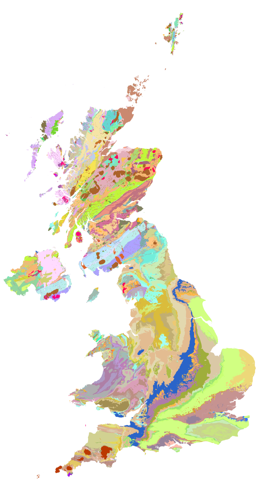
British Geology Survey
The new iGeology mobile app allows smart phone users to discover the geology literally under their feet and is used by around 1,000 people a day
A true pioneer in the application of GIS, the British Geological Survey (BGS) has launched four highly innovative GIS-enabled solutions to make its geological data more accessible to a wider audience. Developed using Esri’s ArcGIS platform, these state-of-the-art solutions include a mobile app that has been downloaded over 170,000 times.
The Customer
The British Geological Survey (BGS) is the longest running national geological survey organisation in the world. Since 1835, it has been sharing its knowledge of the geology of Britain with governments, industries, academics and the general public.
The new iGeology mobile app allows smart phone users to discover the geology literally under their feet and is used by around 1,000 people a day
BGS’s tablet solution combines GIS, camera and GPS technology to show people geological information transposed on the view right in front of them
A web-based map viewer, used by 40,000 visitors a month, provides interactive geological maps, while a range of web services is available for GIS professionals
The Challenge
BGS has been conducting geological surveys and building a national geology record for more than 180 years, so it should come as no surprise to learn that it has amassed vast data assets. It maintains a national geological map of the whole country at 1:50,000 scale and publishes intricate scientific information on everything from Britain’s bedrock, groundwater and earthquake fault lines to boreholes and soil.
The organisation already made much of this data available free of charge via its web site, but wanted to improve access to these and other resources and encourage more people to make use of them. In 2009, it therefore launched ‘OpenGeoscience’ a new strategy to expand the use of its data assets and support the government’s Open Data agenda.
Patrick Bell, Information Systems team leader at BGS explains: “OpenGeoscience was about bringing all our free resources together, making them easier to find and use, and creating new channels for publishing open data in different ways to more people.”
OpenGeoscience was about bringing all our free resources together, making them easier to find and use, and creating new channels for publishing open data in different ways to more people
Patrick Bell – Information Systems team leader at British Geological Survey (BGS)
The Solution
BGS was one of the first organisations in the country to use Esri geographic information system (GIS) solutions in the mid-1980s. Since this time, it has remained both a loyal Esri UK customer and a true pioneer in the development of innovative GIS solutions. In pursuit of its OpenGeoscience goals, the organisation broke ground in the field of mobile GIS, becoming one of the first organisations in the UK to develop free GIS apps for smart phones.
BGS has developed four GIS-enabled solutions as part of OpenGeoscience, each one designed to deliver BGS data in a convenient format to a different audience:
Web-based map viewers – Anyone can visit OpenGeoscience online to view, pan, zoom and interrogate interactive maps on a range of topics including London’s soil geochemistry, groundwater levels over time and seabed samples. The organisation’s most popular map viewer is ‘Geology of Britain’, which today receives up to 40,000 visitors per month.
Mobile apps for iphone, ipad and android – At the forefront of mobile GIS development, BGS created the iGeology app, which allows people to find their current location using GPS and discover the geology literally under their feet. The app has been downloaded over 170,000 times; it has served up 70 million maps to date; and is used by 1000 people a day.
Web mapping services – For those familiar with GIS, BGS offers several of its data archives as web services that can be integrated into other systems. Third party organisations can take advantage of these services to combine geological data with their own data and gain fresh insight into their land and property assets.
A 3D data viewer – BGS’ newest solution is the augmented reality iGeology 3D for android. Highly innovative, this mobile app utilises the GPS, camera, tilt sensor, compass and motion detector functions on tablets to create a 3D scene of the landscape in which a person is standing – and then layer geological data on top of this scene. As the person moves, the data displayed synchronises with the changing view.
All four of these solutions have been developed using Esri GIS. BGS uses Esri’s ArcGIS Desktop solution to prepare its data and then employs Esri’s ArcGIS Server technology to publish the data to all of the web-based and mobile solutions in a standard, interoperable format.
ArcGIS allows us to give many different people, many different ways to access our geological data, whether they are at home, at work or in the field
Patrick Bell – Information Systems team leader at BGS
The Benefits
The GIS apps and web-based GIS services developed by BGS make it easier for people to discover and use geological data. “ArcGIS allows us to give many different people, many different ways to access our geological data, whether they are at home, at work or in the field,” says Bell.
There has been a substantial increase in the number of people using BGS’ resources, and the organisation is confident that its geological data can now reach a wider demographic. The GIS-based iGeology app and online map viewers mean that people don’t necessarily have to have specialist knowledge and software to be able to view and use geological maps.
BGS anticipates that this increased use of its data resources will bring long term advantages for the whole country. “Ultimately, our hope is that our data will stimulate new commercial projects and businesses that will benefit the economy as a whole,” Bell says.
In addition, the innovative application of GIS, and web services in particular, help BGS to deliver a better quality of service to outside organisations. It used to take several hours for a BGS employee to copy required data sets onto CDs and post them out. Now organisations can access the most up-to-date data straight away by ‘self-serving’ from the Internet.