Helping 500,000 people participate in national celebrations
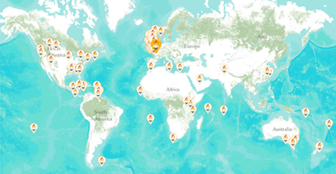
To commemorate the Queen’s Diamond Jubilee, over 4,200 beacons were lit around the UK and across the Commonwealth. Esri UK used ArcGIS to create an interactive web map to publicise this unique occasion and help over half a million people find their nearest beacon.
The Customer
For centuries, beacons have been lit across Britain to mark significant, historic occasions. In 1897, a chain of beacons burned nationally to commemorate the Diamond Jubilee of HM Queen Victoria, so it was only fitting for a similar event to be organised as part of the celebrations to mark the Diamond Jubilee of HM Queen Elizabeth II in June 2012.
The web-based map developed by Esri UK displayed the locations of 4,200 beacons, making it easy for people to find the ones nearest to them and get involved
Esri UK published the map online and shared through social media to help promote the event; the map was viewed by over 500,000 people
The event was a huge success and the Queen’s Pageantmaster applauded the role played by Esri UK
The Challenge
The organisers of the Queen’s Diamond Jubilee celebrations initially aspired to light at least 2012 beacons, across the UK, Channel Islands, Isle of Man, Commonwealth and Overseas UK Territories. In fact, more than 4000 beacons were prepared for the occasion, including a chain of 60 beacons along the length of Hadrian’s Wall.
Jim Sibbald an account manager at Esri UK was one of many thousands of individuals who was keen to see the spectacle of the beacons and wanted to find out about beacon sites close to where he lived. With his experience of working with geographic information system (GIS) technology, he immediately recognised that it would be highly beneficial if there were an online map, indicating the precise locations of all beacons across the UK.
Sibbald explains: “While looking for my nearest beacon, I came up with the idea of Esri UK assisting by displaying a map of the beacons. I felt certain that an interactive map would help to promote the nationwide beacons and encourage more people to go to see these symbols of celebration in their own localities.”
The Solution
With the backing of Esri UK’s senior management, Sibbald approached Bruno Peek OBE MVO OPR, Pageantmaster for The Queen’s Diamond Jubilee Beacons, and put forward his suggestion. The proposal was accepted.
Esri UK created the map using Esri’s ArcGIS.com solution, a web-based GIS application that enables users to quickly and easily create sophisticated online maps, containing multiple layers of data, with just an internet browser and web connection. All data is hosted in the cloud.
In this case, the solution enabled the Pageantmaster to use Beacon data provided by event organisers across the UK to quickly create an attractive and informative interactive map, embedded within the official website.
Esri UK then helped the event’s organisers to publicise the map using a press release, Twitter, Facebook, online advertising and an email campaign. Esri UK also created a ‘map my tweet’ map to show the locations of tweets relating to the beacons. As a result of all this activity, the map was promoted by leading news media including BBC News, ITV News, The Mirror, The Telegraph and several national radio stations.
Esri UK provided us with a unique map for The Queen’s Diamond Jubilee Beacons and I applaud the teams’ efforts
Bruno Peek – Pageantmaster for The Queen’s Diamond Jubilee Beacons
The Benefits
Esri UK’s Diamond Jubilee Beacons map was up and running in time for the launch of the official Diamond Jubilee Beacons web site. It featured prominently on the front page of the site, providing visitors with a very easy way to search for and find events close to their homes. All people had to do was enter their postcode and the map would automatically zoom into their area and show the locations of nearby beacons. The map displayed not only the beacons in the UK, but also those around the world from Canada and the Falkland Islands to Kenya and Australia.
The map proved very popular with members of the public. Indeed, in the lead up to the event, Esri UK’s Diamond Jubilee Beacon map received more than half a million visits. ArcGIS Online can instantaneously scale up to meet high demand and, at its peak, the Diamond Jubilee Beacon map received over 1,000 visitors per minute. This huge number of visitors is a clear indication of how valuable the online map was, for people around the country.
On the evening of 4th June 2012, around 4200 beacons burned across the UK, from Unst, the most northerly inhabited island of Scotland, to Jersey. Flames lit up the huge historic sites of Lindisfarne Priory and Dover Castle, as well as the smallest church in regular use in Ireland. Beacons also topped the highest peaks of England, Scotland, Wales and Northern Ireland. “It was an honour to support The Queen’s Diamond Jubilee Beacons,” says Sibbald. “I believe that the online map will have helped many more people to actively enjoy their local beacon ceremony – by enabling them to find out where to go or by helping them to identify beacons they could see.”
The organisers of the The Queen’s Diamond Jubilee Beacons were very appreciative of the role that Esri UK played in helping to make the event such a huge success. “I am delighted at the work that Esri UK undertook,” says Peek. “Esri UK provided us with a unique map for The Queen’s Diamond Jubilee Beacons and I applaud the teams’ efforts.”


