There are not many GIS professionals who have a background in psychology. Yet Andrew Gasiorowski’s experience of studying the mind and human behaviour has proven invaluable in his role as Principal Information Development Manager and GIS Lead at Public Health Scotland. His scientific insight into how people communicate and respond to information has helped him understand how GIS systems can be used to convey information effectively to large numbers of people -- especially in a public health crisis.
When news of a possible global pandemic first emerged in early 2020, Gasiorowski knew just how important public communications were going to be. He began thinking about how he could combine his GIS skills, his understanding of people and Esri’s ArcGIS technology to make accurate information available to the general public in a clear and simple format. His foresight was accompanied by speed. Before any cases of COVID-19 had even been recorded in Scotland, or indeed anywhere in the UK, he had developed a prototype dashboard for displaying live information about the numbers of cases and deaths in Scotland.
“I knew that communicating with the public was going to be critical,” he says. “Scotland was in a state of alert and Public Health Scotland needed to be ready.”
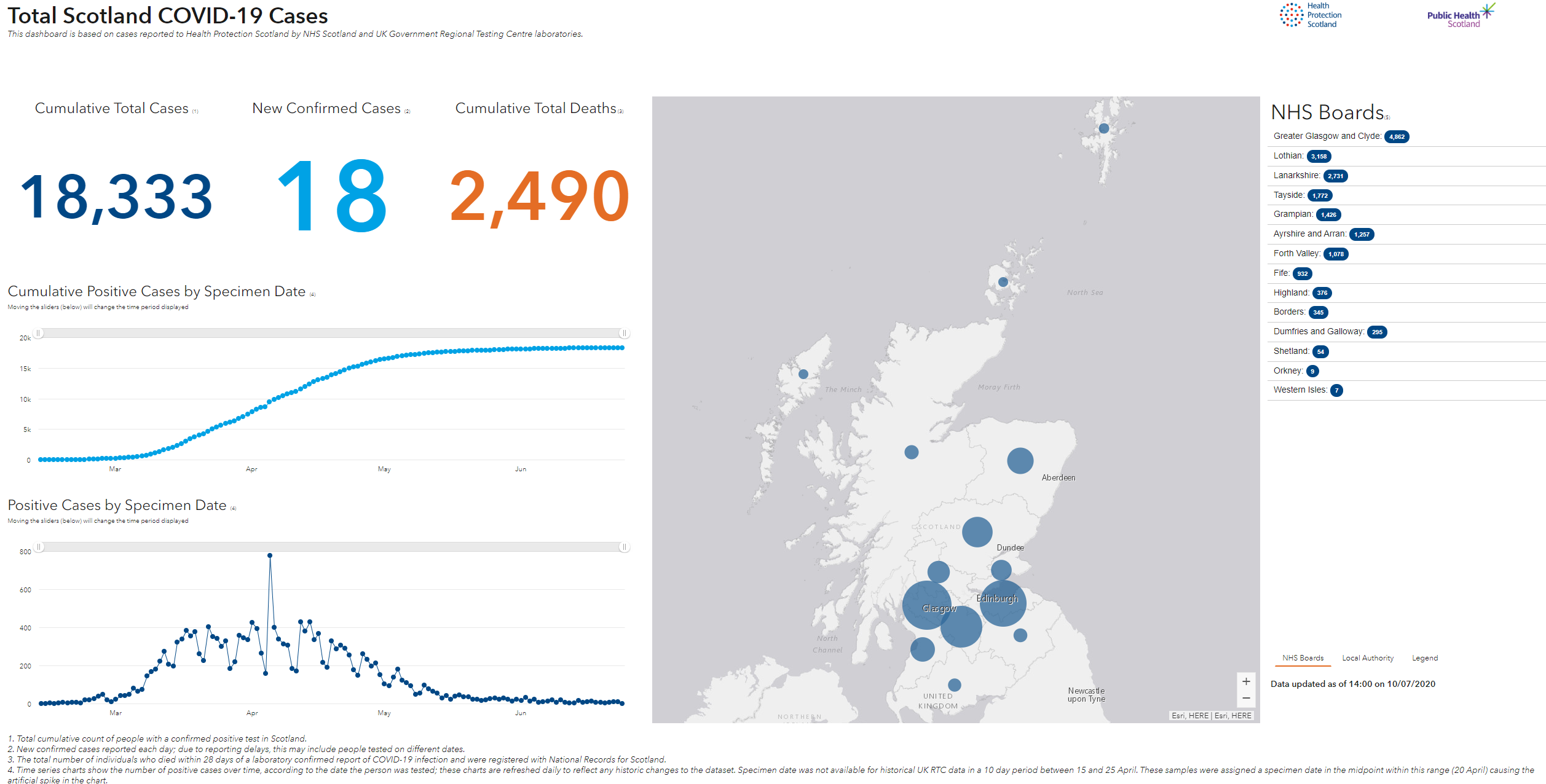
Public Health Scotland published the COVID-19 dashboard on its website at the height of the coronavirus crisis from April to June 2020, providing the general public with an accurate picture of the spread of COVID-19 both within the community and in hospitals. People could easily see an overview of daily cases and daily deaths for Scotland. In addition, they could use the embedded interactive ArcGIS maps to zoom into specific regions and see the cumulative number of cases by local authority area.
Gasiorowski believes that the map formed a very important element of the Public Health Scotland COVID-19 dashboard, because it aided understanding. “Displaying information on a map helps people to understand it without large amounts of explanation,” he says. “People could use the maps on the dashboard to understand the implications of the virus in their own localities and see differences between local authority areas in Scotland.”
During the crisis, especially in the early weeks of the pandemic, there was an overwhelming amount of information in the media, coupled with false news, and it was easy for people to become confused and worried. “There was so much coming at people all the time, from so many directions, Public Health Scotland needed to be really clear,” Gasiorowski notes. “The Esri dashboard enabled us to communicate a high level overview of what was happening in the country and provide information that people could trust.”
All the data displayed on the Public Health Scotland COVID-19 dashboard was based on positive test results, so the data was highly authoritative. When using the dashboard, the general public was viewing the same data that was used by Scotland’s First Minister in her daily briefings and published in government reports.
Gasiorowski recognises that GIS has a key role to play in improving awareness of a wide range of public health issues in Scotland. He was recently involved in a GIS project that analysed the locations of secondary schools and fast food outlets and revealed that a shockingly large proportion of pupils are just a five minute walk away from an unhealthy meal after school. This research is now being used to inform strategies to promote healthier lifestyles and address childhood obesity.
Even decisions about the best locations for NHS services are now increasingly being made with reference to GIS analysis. Gasiorowski explains, “We use ArcGIS to analyse data on medical conditions, healthcare services and facilities going back as far as 1922. We can then use this insight to help NHS Scotland make informed decisions about where to base new services to meet patient demand and deliver better outcomes.”
Gasiorowski has been very busy in recent months and he doesn’t expect much let-up in his schedule. Indeed, he believes that as the coronavirus threat moves into a new phase, demand for GIS solutions within Public Health Scotland could surge. “The COVID-19 pandemic has highlighted that there is a real need for public health information to be communicated spatially,” he says. “Especially with track and trace, we need to be able to see not only what is happening, but where it is happening. More than ever before, understanding location is going to be the key to protecting public health.”

Andrew Gasiorowski - Public Health Scotland