Lisa Reilly is the geographic information system (GIS) Analyst at South Ayrshire Council, a position she has held for over ten years. While there are a few people who use GIS as part of their wider job role, Reilly is the only dedicated GIS professional in the whole organisation with the role of using her technical expertise to customise advanced GIS apps and services in-house. Currently assigned to the council’s Transformation Team, she is quietly applying her GIS knowledge and skills to the challenge of delivering public services more efficiently—and making a huge impact.
The efficiency mission
Across all local authorities in the UK, funding is limited, demand for services is increasing and pressure to deliver the elusive ‘more for less’ is as strong as ever. In common with other councils, therefore, South Ayrshire Council needs to find time- and cost-efficient ways to deliver public services. Reilly is playing a key role in this efficiency mission by building GIS apps and services that enable staff to work smarter.
For example, Reilly has created a GIS-based process for the Forestry Service that enables it to respond to reports from members of the public about damaged or diseased trees far more quickly and effectively. Built with ArcGIS Survey123, ArcGIS Field Maps and Python scripts, the solution ensures that information is passed digitally from the admin team to tree inspectors, who then use an app on their mobile devices to find the tree and verify its condition. If remedial work is required, a work job is automatically created and passed to the relevant forester. Requests (such as requests for land access) are automatically sent and permissions are recorded.
Previously, the Forestry Service used to capture reports from the public in Excel spreadsheets and pass the information on to tree inspectors on paper. Tree inspection results would be recorded on another piece of paper in the field and passed back to the admin team to type up. Then another piece of paper would be given to the forester who was assigned to do the tree surgery. The end-to-end digitisation of this key process has removed hundreds of hours of manual effort annually and accelerated the response to damaged trees, while improving the quality of the data collected.
A decade of innovation
In over a decade at South Ayrshire Council, Reilly has built numerous mobile GIS apps like this one for use in the field. Some have been created to meet a short-term, one-off need, such as the ArcGIS Field Maps app that was introduced to help the Waste Management Service plan and distribute new recycling bins. Others have been created for frequent, daily, weekly or annual use. For instance, Reilly has built a mobile app with ArcGIS Survey123 that streamlines surveys of derelict land parcels to support development planning and government reporting.
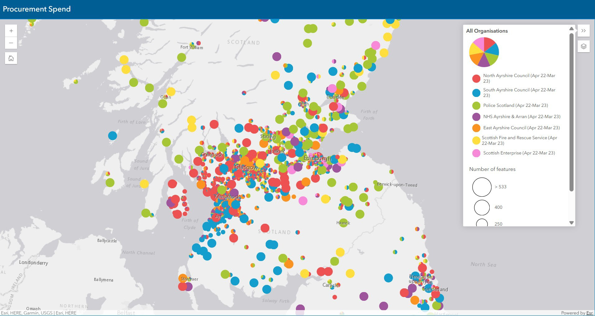
As well as mobile apps, Reilly has also built ArcGIS web apps and dashboards for use by office-based staff. In one particularly interesting project, Reilly used ArcGIS Online to map and geospatially analyse the council’s procurement budget. She took data previously only held in spreadsheets and used it to show, visually, where the council was spending most of its money. The Procurement team could then clearly see the proportion of the council’s annual expenditure that was going to businesses within South Ayrshire, within Scotland and beyond.
Taking this one step further, Reilly also analysed publicly-available, multi-agency data on the expenditure of other public sector bodies, such as Police Scotland. Using a combination of pie charts and heat maps she succeeded in making very complex data instantly understandable. “We could see opportunities to encourage more spending with Ayrshire businesses to support our local economy,” she says. “ArcGIS enables us to see patterns and trends that wouldn’t have been visible when the data was stored in a tabular format.”
The appetite for more
Reilly’s recent successes have shone a keen spotlight on the power and potential of GIS within the council. “I’ve seen a real change in attitudes towards digital systems,” she says. “Whereas there was initially some resistance to change internally, now people are coming back to me with ideas for new GIS-based process transformations. They are wanting more.”
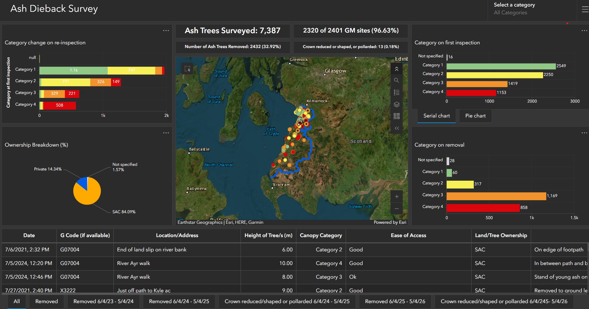
The Forestry Service, for example, approached Reilly asking if it might be possible to build a mobile solution for managing the implications of ash dieback disease. Impressed with the success of the GIS solution for responding to public reports of tree damage, the team was keen to have something similar that it could use for inspecting and removing diseased trees. Of course, Reilly responded and delivered.
Built primarily with ArcGIS Field Maps and ArcGIS Online, Reilly’s ash dieback solution doesn’t just allow inspectors to survey trees and collect data in the field; it also enables staff to see the locations of ash trees in South Ayrshire on interactive dashboards, monitor the spread of disease, understand the scale of the problem and collect accurate information for funding requests. “We can now see, very easily, what proportion of ash trees are diseased and where trees have been removed or pollarded,” Reilly explains. “This insight can be used in the future to inform a positive new replanting programme.”
Innovative solution design
Reilly is currently working on a very creative and unusual project with the Neighbourhood Services Team. The council has commissioned a modern, metal sculpture for Ayr’s seafront that will comprise hundreds of beautiful metal leaves. Members of the public will be able to purchase a leaf for this eye-catching installation and have it inscribed and placed on the ‘hedge’ for five or ten years as a memorial to a loved one.
The ArcGIS web app that Reilly is building to support this new, high-profiled initiative uses the ArcGIS REST API to integrate ArcGIS Field Maps with the council’s customer relationship management (CRM) software and Microsoft Power Automate. Thanks to the innovative design of this solution, the entire complex, back-office process of capturing customer orders for leaves, getting them engraved and issuing work orders for the leaves to be installed, is fully automated. The incredibly sophisticated GIS-driven process also issues alerts after five or ten years and manages the process of returning engraved leaves to families.
Reilly has lots more creative ideas in mind for future innovative projects, many of which will harness new functionality in ArcGIS Field Maps. In particular, she wants to incorporate more reporting features into existing and new apps. Incredibly, all this activity will be balanced against her responsibilities as a small holder, caring for two pigs, twenty five chickens and seventeen ducks, as well as peacocks, dogs and cats.
A GIS visionary
A life-long map enthusiast, Reilly studied geography at Glasgow University, at a time when GIS was just a single module in a four-year degree course. At the beginning of her career, she took a job at North Ayrshire Council administering the council’s corporate address gazetteer. She gradually expanded her IT and GIS capabilities over the next ten years, rising to the position of GIS Analyst. She then moved to neighbouring South Ayrshire Council, where she has been busy building GIS solutions ever since.
All of the new GIS solutions that Reilly creates for South Ayrshire Council are built using the council’s existing licenses for ArcGIS. Therefore, besides Reilly’s own time, there is no additional cost to the council for any of these new digital processes that deliver such huge efficiency improvements. “If we had had to purchase a third party system to manage forestry requests, for example, it would have been really expensive,” says Reilly. “By creating new digital solutions in-house with ArcGIS we are definitely saving money.”
Within Esri UK’s government team, Reilly is known as a GIS visionary. In her unassuming, modest way, she is quietly transforming one process after another, largely alone, and making a huge difference to the council’s efficiency. Her approach to situations is unfailingly creative, which results in solutions that are integrated, automated and precisely designed to meet the needs of users. When asked, she says her vision probably stems from her propensity to let her mind wander. “Day dreaming has its disadvantages but also its advantages!” she explains. “It’s where I find my ideas!”
Whatever the source of her creativity, her impact at South Ayrshire Council is undeniable.
 Lisa Reilly - South Ayrshire Council