For nearly thirty years, engineer James Coles has been pulling on his boots day and night, in storms and blizzards, to search for people lost and injured in remote mountainous areas of Scotland. Now the Team Leader for the Moffat Mountain Rescue Team near Lockerbie, he is devoted to searching not only for missing people but also for better ways to plan highly complex life-saving rescue operations.
Coles’ years of experience in mountain rescue have taught him that effective planning in a search operation is essential. When every hour that passes can mean the difference between life or death for someone missing in a harsh environment, mountain rescue teams need to make rapid, well informed decisions about where to focus their search efforts and how best to deploy different resources. It was this insight that drove Coles to investigate GIS and instigate the development of a new kind of planning tool, specifically for complex search and rescue operations. Built using Esri’s ArcGIS Online, this intuitive solution allows team members to identify search areas and plan recovery activities more effectively.
Remarkably, Coles is driving the development of this vitally important GIS solution in his free time. Like dozens of other experienced mountaineers in Scotland, he gives up his time voluntarily to help those who get into difficulty in the mountains around his home town. In his professional life, he is a site engineer and maintenance manager at a firm that manufactures industrial polyester films for use in solar panels, touch screens and medical test strips. Balancing the demands of his challenging voluntary role alongside the responsibilities of his full-time position isn’t always easy, but he is driven by the knowledge that what he does really helps to save lives. According to the latest data from Scottish Mountain Rescue, a staggering 740 people received vital assistance from mountain rescue teams in 636 incidents in Scotland in 2022 alone.
Complex search operations
A variety of tools are available to help mountain rescue teams recover people when their location or GPS coordinates are known or can be derived from mobile phone data. But when the precise locations of missing people are unknown and there has been no recent communication from them, searches are far more complicated. Vast areas need to be divided up into manageable search areas and each location prioritised using local knowledge and experience. Multiple teams are often involved in these call-outs, and search operations will typically be planned in a series of phases, involving on-the-ground teams, drones, specially-trained search and rescue dogs and helicopters.
Coles estimates that there are at least 20 of these multi-phased, complex searches for missing people in Scotland every year. He recalls a particularly challenging search for walkers missing on the mountains during the storm nicknamed ‘Beast from the East’. Multiple teams from two different search organisations searched all night in waist-deep snow, with a police helicopter joining the search effort at dawn. After twelve hours, the two walkers were found - exhausted but alive. “This experience really illustrated the importance of being able to properly plan the activities of different teams to avoid duplicated effort and maximise the area searched,” Coles says.
Designed precisely for challenging scenarios like this, the ArcGIS Online solution enables members of the Moffat Mountain Rescue Team to view up-to-date digital maps from Ordnance Survey, as well as maps of trails within Forestry Commission land and privately owned estates. They can then define and compare different search areas and plan successive search phases, allocating different locations to specialist and regional teams, dog handlers, helicopters and drones to avoid duplication of effort and ensure that every likely location is properly searched. During a search operation, an ArcGIS map showing planned search areas and phases can be displayed on a digital screen, mounted to the wall of Moffat Mountain Rescue Teams support vehicle, where it can be used to help coordinate activities.
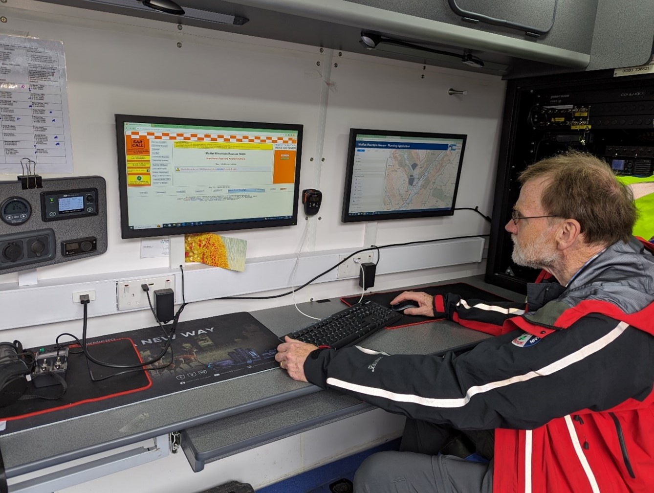
ArcGIS being used within Moffat Mountain Rescue’s incident response vehicle
A “manual GIS”
When Coles first started volunteering with the Moffat Mountain Rescue Team in 1994, the group had no support vehicle, no mobile phones and only six radios. It had a small storage area in a lean-to at the back of the town hall and used cells in the local police station to dry out equipment after use. Coles and other volunteers used to overlay acetate sheets on top of Ordnance Survey maps and draw on search areas with permanent markers. As the search progressed, more acetate sheets would be added to show successive search phases, sightings, points of interest and areas searched by other teams.
This approach had obvious limitations. Permanent marker couldn’t be rubbed out when things changed, and it was hard to make sure that all of the acetate sheets lined up correctly—particularly when leaning on the bonnet of a Range Rover in gale-force winds! “Each acetate sheet was effectively a data layer,” explains Coles. “What we had back then, in many respects, was a manual GIS system, before we even knew what GIS was.”
Then, around 15 years ago, Coles got involved in a project led by Scottish Mountain Rescue to develop a digital mapping solution that could be used by the 28 voluntary civilian mountain rescue teams and 3 specialist police mountain rescue teams in Scotland. The resulting planning solution was a bespoke software development, called ‘Mountain Map’, that is still in use in some locations across Scotland today. “When it was developed, Mountain Map was revolutionary,” Coles says. “It got rid of the need for acetates for sure, but by 2022 it had become outdated and, as it wasn’t based on standard software, it couldn’t be easily adapted. A fresh approach was needed.”
The fresh approach
Taking the initiative, Coles started researching digital mapping techniques and discovered that Esri UK has a Not-for-Profit Scheme that enables charities and voluntary organisations to access industry-leading GIS software. After a few conversations, Esri UK was able to build a prototype system for Moffat Mountain Rescue Team with ArcGIS Online that turned Coles’ need for a fresh approach into a tangible solution. “The prototype made a huge leap forwards and gave me the foundation I needed to develop a real game-changing search and rescue application,” he says.
Leveraging what he has seen and learned about ArcGIS Online since then, Coles is now keen to further develop the planning tool. In particular, he aims to make the tool more accessible to team members and partners, to help Moffat Mountain Rescue Team work effectively in collaboration with the Scottish Police, neighbouring search and rescue teams and other emergency responders. “My goal now is to make the ArcGIS Online app better and better and truly collaborative,” he says. “I am working towards being able to share search areas with team members on the ground via their mobile phones and teams from other regions via web apps.”
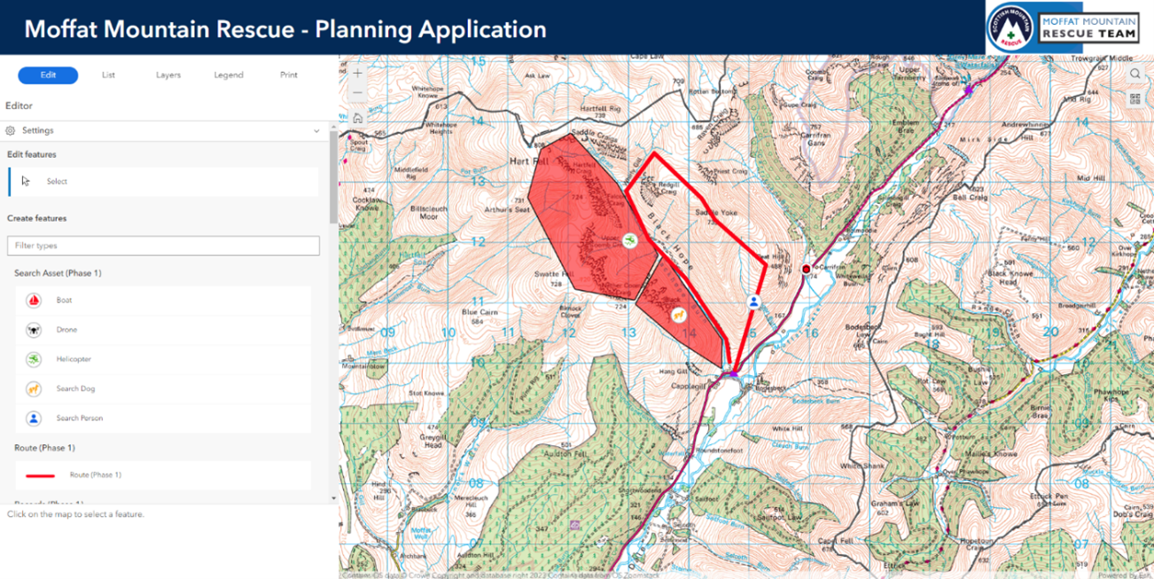
An ArcGIS screenshot showing where searches on foot, with dogs and via helicopter will take place
In whatever comes next, ease of use will be key. “I need to develop solutions to pass the 3 o’clock in the morning test,” says Coles with a knowing grin. “Apps need to be so easy to use that volunteer mountaineers can use them with little training, halfway up a mountain, in the dark, with cold fingers and tired eyes! ArcGIS Online has the capability to deliver this functionality and I am keen to make it happen.”
Undoubtedly already a hero for his years of service as a mountain rescue volunteer, Coles is clearly also now proving to be a GIS hero. Using ArcGIS Online for the first time, he is single-handedly driving the transformation of the planning tools available to rescuers with the Moffat Mountain Rescue Team and, as a result, improving their ability to save lives.
 James Coles - Moffat Mountain Rescue Team