As the COVID-19 pandemic impacts the rules of human interaction, business and organisational leaders must establish a new definition of workplace safety for their facilities.
In this Think Tank, Esri’s Brian Cross talks to indoor mapping experts Will Isley and Beau Ryck about the conversations they’re having with business leaders, what it means to establish a common operating picture of an organisation's facilities, and how to create a new level of safety in the workplace. Esri’s Pat Wallis provides additional context throughout the interview.
Brian Cross: We’ve explored the trend of indoor mapping in the past, and that topic is quickly gaining attention as business leaders contemplate new patterns of work and challenges to safety and health in the workplace.
To put this in perspective, I thought we could start by discussing what workplace challenges executives were solving with indoor maps before COVID-19?
Beau Ryck: The main challenge has been developing a system of record that organises building and floorplan data. Employers use this to improve workplace experiences for employees and visitors—through wayfinding and room-booking applications, for example. They also use the data to manage maintenance more efficiently. Indoor maps create a common operating picture that allows them to manage buildings and equipment as assets.
Cross: Now you’re both helping companies address new priorities as they respond to COVID-19. We’ll explore those in a minute, but I’m curious whether you see this pandemic having long-term effects on the workplace?
Will Isley: I think COVID-19 will change the workplace in lasting ways—similar to the way September 11 changed security practices in the airline industry. Safety has always been a basic premise of the workplace, but you might say it lived in the background. Now it’s at the top of every executive’s agenda, and will be for the foreseeable future. Companies have to protect their employees, because if workers aren’t safe, operations can’t continue.
Ryck: I agree. Safety challenges in the workplace won’t go away once the COVID-19 threat fades. Natural and human-made disasters will continue to occur, and executives will need situational awareness of their facilities to manage those events. I think the pandemic will drive businesses toward better systems for dealing with hazards and disaster planning. Longer term, as business leaders grow more comfortable with a remote workforce and flexible working schedules, some might even re-evaluate their real estate holdings and shed leases. It’s really interesting to see how mapping technology is helping guide these decisions.
Article snapshot: Business executives and organisational leaders are faced with the unprecedented challenge of how and where to resume operations following the COVID-19 pandemic. Indoor maps are helping them create and execute plans for a new version of workplace safety.

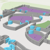
The business leaders we’ve talked to do not want to totally rebuild floorplans—they want to make adjustments to keep employees safe. Some will create round robin schedules so certain employees are in the office on days when their adjacent neighbours are not.
Pat Wallis, Esri
Navigating a New World of Work
Cross: In the COVID-19 world, what are some emerging uses for indoor mapping?
Isley: Indoor maps are being used in three aspects of the COVID-19 pandemic. The first is direct response. This mostly involves front line locations like hospitals, shelters, pop-up facilities, and campuses that are providing emergency services and health care. They need to understand how to adapt their indoor space to safe distancing, help people find the resources they need, understand and address facility issues, define new health procedures, and more.
The second technique involves planning indoor space for use when employees return to work. Companies need to map out seat assignments and safety procedures and understand who’s in the office, who’s not. They also need to know where maintenance has been performed and how physical systems are operating.
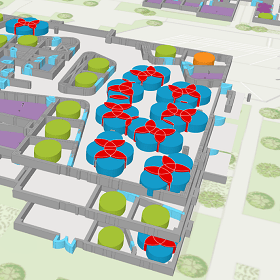
The third is advanced analysis of the indoor environment. For example, companies are preparing response plans in case an employee contracts the virus. They’re looking to create a common operating picture—a real-time map—of the workplace. That’s a new level of indoor awareness for most companies.
Will Working from Home Reshape the Population?
As more employers recognise the benefits of a remote workforce, the dynamics of the country’s demographics could change. Under remote work arrangements, people will be free to live where they choose, rather than where the office is. That could rearrange cities, towns, and rural locations across the country. Companies that have used GIS to analyse consumer and demographic trends will monitor these changes over time and assess their business implications.
Managers want a real-time view of the office—a common operating picture to help them keep the workplace safe. Indoor maps are helping provide that visibility.
Pat Wallis
How Executives Are Rethinking Indoor Space
Cross: I imagine a lot of the executives you work with are focused on adjusting physical layouts and procedures as they begin to reopen offices. What does that involve, and what’s different about it now?
Ryck: Before the COVID-19 outbreak, companies were focused on maximising space usage, since property is the second-biggest expense on their books. In some cases, they did this through space-sharing practices like hoteling and hot desking. Some of those practices will survive this pandemic—especially since many employees will now work partly from home and partly in the office. But much more governance will be involved. Employees won’t be able to show up at the office and grab an available desk.
Hoteling, for instance, is a managed process—it can be run on interactive maps that account for social distancing. Employees can reserve space on the map, managers can approve the assignments, and the system will alert maintenance staff when shared spaces need to be sanitised.
We see planners using space analysis to find choke points in their facilities and reduce the possibility of congestion. They’re using indoor maps to make adjustments to the space and ensure social distancing.
The old definitions of capacity no longer apply. Companies are trying to de-densify their space, which means they need to closely monitor reduced capacity and make sure they're not putting employees at risk.
Pat Wallis
Data Points toward Phased Openings
Cross: I imagine executives with facilities in multiple states might find it difficult to gauge the readiness of each property. How will they decide when and how to open facilities?
Isley: The business leaders we’ve talked to are doing location analysis. They know that the COVID-19 reality in New Jersey, for instance, is very different from that in Idaho. Even within a state, infection rates and risk levels vary substantially by location.
Executives know how important good data is to good decisions, so they’re using technology like a geographic information system [GIS] for analysis. For example, they might use GIS to analyse data on COVID-19 trends, including statistics such as the number of days since a county’s last reported COVID-19 case and the status of its infection rate—from emergent to end stage. That gives decision-makers the location intelligence they need to make plans specific to each facility.
Ryck: This is where traditional GIS and indoor GIS intersect. Once executives gauge the readiness of each facility based on state and local data, they’ll map out new procedures within each facility.
Cross: How will they deal with the variations across locations—how will that process play out?
Isley: We expect many companies to create a tiered reopening system. A facility at tier two, for example, might enforce certain rules: open space seating is prohibited, no more than 40 percent of the workforce can be in the workplace, and social distancing is managed very strictly. For a facility at level four, that might mean 75 percent of the workforce is back in the office, visitors are allowed with special permission, and common spaces are open but with limited seating in lunch areas.
Employers will design and manage those scenarios on smart maps. When local and county-level laws and data indicate that a facility can move to the next level of openness, a manager can click on the level 3 plan in GIS, and the indoor map will display the game plan for that tier—for managers and employees.
Company executives are monitoring federal, state, and local orders for business openings, and they’re also performing their own GIS analysis to understand the right time for each facility to reopen, and the appropriate restrictions to enforce.
Pat Wallis
Responding to Instances of COVID-19
Cross: Despite their best efforts to protect employees, companies could still face a situation where an employee contracts COVID-19. How will organisations deal with that?
Ryck: The White House issued guidelines stating that employers should be prepared to implement contact tracing if an employee tests positive for COVID-19. The guidelines aren’t specific about how that should happen, so companies are looking for best practices.
Some companies are using location technology on mobile devices to allow staff to self-report. If I’m working from home for the day, I check in on the app, report where I’m working, and note if I have any COVID-19 symptoms. Managers see a map of who’s in the office and who’s off-site, and what everyone’s status is.
This mapping capability supports basic contact tracing, because employee check-ins are saved for a certain period—say, three weeks. If an employee reports symptoms, a manager can essentially rewind the map over the past two weeks and see which colleagues that employee may have come into contact with.
We’re working with large organisations in public and private sectors that are doing this for thousands of employees.
Isley: In certain high-risk work environments, companies will want to do more rigorous contact tracing. They’ll use a combination of mobile devices and indoor positioning technologies like Wi-Fi access points or Bluetooth beacons to understand where employees are as they move through facilities. Apple, Google and other tech companies are providing SDKs for proximity detection, too. If someone tests positive for the virus, algorithms in GIS technology can help managers figure out who that person came into contact with.
New Practices in Every Space
The impacts of COVID-19 on indoor spaces are profound. While offices and other workplaces adjust to a new level of safety, other facilities are doing the same. Airports are looking to de-densify passenger flow through terminals, better manage TSA wait times, and shift people to different locations to minimise congestion.
Schools are mapping new traffic flows to move students from classroom to classroom safely. Across industries, indoor maps are helping planners create safe procedures in a changed world.
Restarting Operations
Cross: So far, we’ve focused on employee activity, but what about the physical operations of offices and workplaces?
Ryck: If facilities have been largely unoccupied or running at minimal capacity for some time, organisations will want to ensure that mechanical systems are functioning safely as operations resume. Historically, maintenance involved a lot of paper-based work orders and physical handoffs. The trend of using digital maps to integrate with work order systems—to manage everything from sanitising common areas to changing air filters—will accelerate. That minimises in-person contact and helps with social distancing.
The Common Operating Picture Moves Indoors
Cross: What I’m hearing across this conversation is that leaders are interested in creating a common operating picture of the workplace. They need to see the workplace in ways they never have before. They need to know how many offices are occupied, where staff are congregating, and which areas need cleaning. Indoor maps are creating that operating picture for managers and executives.
Isley: And for employees, too. Because as space plans change, employees will need to adapt. Some will end up in different office locations, and all will have new procedures to follow. Having an indoor map on their phones will give them the information they need—everything from which areas are off-limits and where hand sanitiser stations are, to the best way to navigate to a conference room or café.
That map will be their common operating picture, and it will update as facilities graduate to fewer restrictions, based on local conditions. This level of awareness will be key to keeping employees safe in a new environment—and helping them and the businesses they represent remain as productive as possible.
Additional Resources for Business and Organisational Leaders: