Sweet for ArcGIS is a powerful tool for ensuring that data is valid at the point of entry. As well as the data rules configured within Sweet, the very nature of the data itself is important for defining the application’s purpose.
Typical use cases for Sweet for ArcGIS include habitat surveying, agricultural management and road network editing, all large outdoor projects. But what if you want to edit an indoor environment? For example, you might be looking to plan a new office space and need to conform to certain building standards, or you might want to track critical assets within a medical facility, ensuring that quantities are correct and that these assets are in optimal locations. Well, with Sweet for ArcGIS you can do exactly that.
An example of an indoor dataset used within Sweet for ArcGIS, the Esri UK head office.
Floor-aware GIS greatly increases facility planning capabilities.
Floor-aware GIS organises the floor plans of an indoor GIS dataset in a hierarchical structure. This arrangement links features to specific levels, with levels nested within facilities, and each facility situated within a site.
To enable us to use floor-aware data in Sweet, we need to go back to the layers in our web map within ArcGIS Pro or ArcGIS Online. To understand that a map is floor-aware and facilitate floor filtering, our web map must, at a minimum, have a layer representing facilities and a layer representing levels. These layers must include specific fields that identify features, which level these are associated with and which facility each level sits within.
Within the wireframe editor of Sweet, a new panel can be added for enabling the use of levels. All you need to do then is apply the appropriate fields, to allow for your application to filter by floor.
Sweet makes use of facility and level layers to enable floor filtering.
You will also need to alter the application’s data rules so that features are filtered for the chosen level. In the filtering tab of the data rules editor, use the Facility ID and Level ID fields to only show the features associated with the facility and level specified in the application.
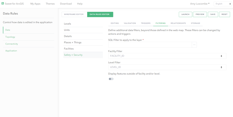
Use filtering to ensure that only the features on the associated level are shown.
Edit features floor by floor.
Once the application is set up to be floor-aware, features can added level by level. You can also create new floors within Sweet itself, expanding the capabilities of the application for design purposes.
Edit your data floor by floor, and add as many levels as you need.
Delve deeper into your indoor data.
This blog has just outlined the beginnings of using floor-aware data within Sweet for ArcGIS. You could also create custom data rules, specific to your indoor needs and the requirements for each floor. Custom panels displaying graphs that dynamically report on your indoor data can also be configured. The world of indoor GIS is your oyster!
Don’t be a dalek, head upstairs!
With floor-aware GIS available at your fingertips, there is no need to limit your use of Sweet for ArcGIS to the ground.
If you have any questions about whether Sweet is the right application for you, please get in touch with your CSM. You can also take out a free 30 day trial here and test it out for yourself.