Tag Archives: Flooding
Enhancing resilience with ArcGIS Pro’s Flood Simulator
At this year’s Esri UK Scottish Conference, we saw the new ArcGIS Pro flood simulator tool in action. This new tool allows you to model how water moves and accumulates in a 3D scene, enabling quick, on-the-fly flooding scenarios. This … Continue reading <
Continue Reading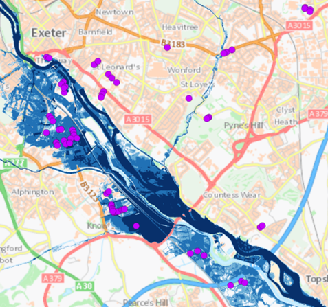
Analysing JBA Flood Maps in ArcGIS
Flooding poses an extreme threat to people’s livelihoods. Heavy rain and storm events cause surrounding rivers and coasts to become inundated with water, bringing a wealth of social, environmental and economic impacts. With floods of greater intensity predicted across much … Continue reading
The UK’s Longest Rivers
Extreme weather events are becoming more common, more unpredictable and more severe. This is apparent all around the world. The flood events in the UK this winter forced many people to evacuate their homes. With World Water Day 2020 … Continue reading
Continue Reading
Environment Agency
ArcGIS allows us to collect, analyse and share real-time information about major incidents and take rapid action to protect people and the environment.
Continue Reading
Worcestershire County Council
Custom-made web mapping services drives innovation across the council, delivering better services for citizens in a more cost effective way.
Continue Reading
Royal Sun Alliance (RSA)
GIS is used to calculate premiums far more accurately, speeding up the turnaround time of risk assessments from several days to being available instantly
Continue Reading
Direct Line Group
GIS technology helps us to gain a better understanding of actual risk factors at individual properties, so we can price policies accurately
Continue Reading