Modernising social housing management with location
In the two years since adopting a location-centric approach to data management, believe housing has made significant progress in delivering better services. By leveraging the ArcGIS System, believe has unlocked its asset and customer data, enabling a more target-based approach to decision-making and resulting in improved outcomes for its customers.
A digital profile of assets, neighbourhoods and customer is supporting cross directorate collaboration
Mobile surveys are resulting in significantly improved customer feedback collection and satisfaction levels
Enhanced risk management is better supporting at-risk residents and driving more accurate insurance premiums
The Challenge
believe housing is one of the largest housing associations in the North East, providing homes and services to a growing population while striving to exceed customer expectations. Each year, it handles over 80,000 property repairs, answers more than 200,000 customer calls, and responds to over 25,000 emails.
In 2022, believe recognised the need to optimise location data usage to modernise social housing management. Data was scattered across spreadsheets, databases, and a central warehouse, making access difficult and time-consuming. Without data being in one central system, the organisation was potentially missing patterns and insights.
The organisation urgently needed a centralised system to unlock and visualise data and make it accessible to multiple user groups. It identified the need for a data management system that would inform decision-making and support a more target-based approach to social housing management, while empowering users with the tools necessary to perform their roles more efficiently.
“We can now produce more accurate, targeted responses to operational issues driven by data, and not guess estimates, which is resulting in a better outcome for our customers.”
Lynsey Darby, GIS Specialist, believe housing
The Solution
In May 2022 following a competitive tender, Esri UK was selected to build a comprehensive enterprise-wide GIS system from the ground up and supply data including OS AddressBase™, The Bluesky National Tree Map™ and Esri UK TitleInfo, a service which combines Land Registry Title Deed polygons with tenure, ownership and other data. The project involved installing Esri’s full software suite including ArcGIS Pro, ArcGIS Enterprise and ArcGIS Online by September 2022. By the end of the year the foundations of the GIS system were established including an enterprise geodatabase, automated and secure daily data update models and a standardised base map for consistent use across all applications.
A central GIS Hub was developed to organise and manage all maps and apps in one place. Within the Hub the Asset Atlas, an interactive web map app, was deployed. The Asset Atlas allows multi-user access to data while providing bespoke user levels and restricted access to safeguard sensitive content.
believe’s GIS specialist has explored various ways to innovate and effectively utilise core datasets. For example, by collaborating with the Risk & Assurance team and using the Environment Agency’s Flood Map for Planning, they identified 309 properties at risk of flooding out of more than 18,500 reviewed. This data was shared with the organisation’s insurers, enabling more precise risk assessments. Additionally, vulnerable customers in at-risk properties were identified, ensuring the organisation could prioritise providing emergency help and support in the event of a flood.
Another significant operational improvement is impacting customer satisfaction. The Major Works team now has a mobile survey system to collect customer feedback immediately after job completion. This replaced the previous quarterly manual surveys which generated only about 60 responses a year and often took weeks to address issues.
Since launching over 1,124 responses have been received in eight months. The system allows for prompt response to negative feedback, with the goal of addressing customer issues within two hours and, where possible, resolving them the same day.
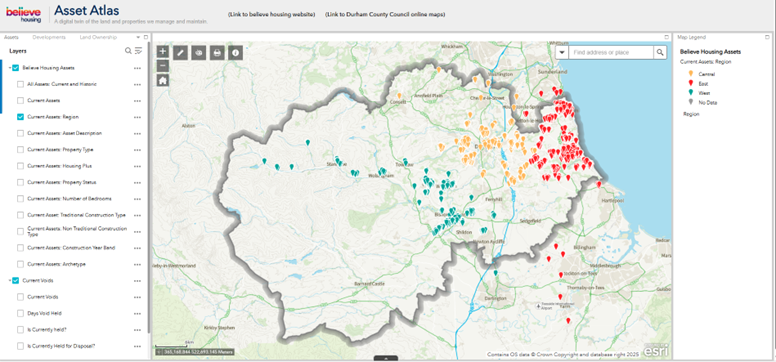
Believe housing's Asset Atlas web mapping application - asset, customer and neighbourhood information viewable in one location.
“Improved customer service is one of the key outcomes of adopting a location-centric data management approach. We can dispatch a contractor to a customer within two hours of receiving a complaint, significantly increasing the likelihood of same-day resolution.”
Samantha Tullock, Assistant Director of Strategic Assets, believe housing
Benefits
Accelerated cross-directorate collaboration
By taking an organisation-wide approach to location data management and creating a digital profile of assets, customers and neighbourhoods, cross-department collaboration has rapidly improved. All users have access to a single truth of the data, viewable from a desk-based environment or mobile device, supporting more accurate, target-based decision-making.
Improved customer service
The new mobile survey process has significantly improved customer feedback collection and satisfaction, enabling faster issue resolution. Customer complaints are responded to within two hours, often resulting in the call-out contractor going back to the property the same day to resolve the complainant’s issues.
Time and cost savings
As customer service levels have improved huge time and cost savings are being made. Users find it easier to access the information they need to gain insights and make target-based decisions and improved contractor management is delivering further cost savings.
Enhanced risk management
The GIS system has enhanced risk management, particularly in assessing and responding to flood risks. This provides residents at risk with greater reassurance in the event of an extreme weather event while the insurance company has a more accurate view of risk, so they can set premiums that reflect the true level of risk.


