Blog Archives

Newham Council
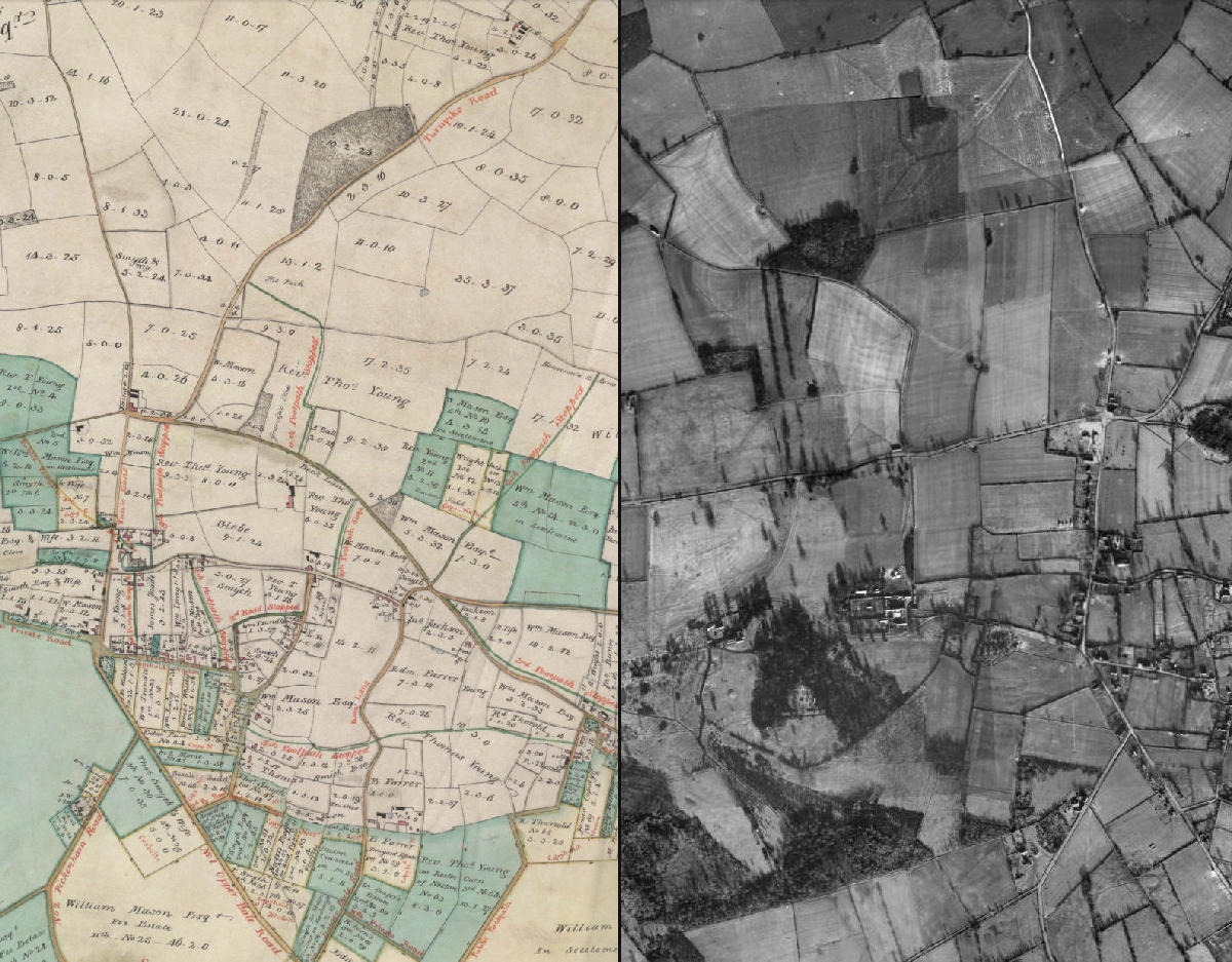
Esri UK’s School Locator App has improved the administration process by providing greater transparency to ensure places are allocated fairly.
With rising numbers of pupils in its borough, Newham Council needed a better way to ensure that school places are allocated fairly based on home to school distances. The solution it developed with Esri UK, the School Locator app, is saving the council significant processing time while improving full transparency of the process for parents.
The Customer
Newham Council is the local authority for the London Borough of Newham, serving a population of 310,500.
The council’s school admissions team can work much more efficiently, maintain high quality standards and process larger volumes of applications with the same number of staff
Parents can access the School Locator app online and see the same information used by the council, including catchment areas and the home-to-school distances tie breakers
The improved school admissions process is expected to save the council money by reducing the number of parent query calls to the call centre and minimising potentially costly appeals
The Challenge
While small in size, Newham Council has one of the largest cohorts of pupils in the whole of London. It processes in excess of 5,000 reception applications and around 4,000 year 7 applications every autumn. In addition, it must allocate school places in response to 7-8,000 in-year applications per annum.
The council had an existing IT system that it used to help it allocate school places according to strict over-subscription criteria, including what catchment and parish children live in and the home-to-school distance (shortest walking distance or straight line). However, this system was very cumbersome and did little to speed up what was a time-consuming, complex and stressful task for the admissions team.
To ensure the quality of its decisions, team leaders used to rigorously check and quadruple check the school allocations. This wasn’t an optimal use of manager time, but the council vehemently wanted to focus on the family and avoid mistakes so every child received the correct school offer. If, for example, home-to-school distances were inaccurately calculated, it could lead to an increase in appeals, substantial administrative and legal costs, damaging negative publicity and a loss of trust in the community.
While council staff found the demands of the admissions process complex, so too did parents and guardians. Many families found it hard to understand how places were allocated, and high volumes of calls were made to the council call centre every year requesting information on home-to-school distances and the precise boundaries of catchments. These telephone enquiries were costly for the council and not necessarily particularly illuminating for parents and guardians.
Esri UK went the extra mile, investing time in really understanding our needs. We had a tight deadline and it seemed like an impossible ask, but, in short, the consultants moved me from a big idea with a skeleton specification to an excellent solution in less than three months
Tracy Jones – Group Manager for Pupil Services, Newham Council
The Solution
Esri UK worked with Newham Council to design a geographic information system (GIS) to precisely address all these issues. Called the Esri UK School Locator app, this solution integrates with the council’s existing CACI admissions system and rapidly calculates accurate catchment and distance information for each pupil and school preference. The solution also integrates with the council’s Local Land and Property Gazetteer (LLPG), to give it accurate, up-to-date address information.
Not just for internal use, the School Locator app also serves up a public-facing web site, where parents and guardians can see catchment areas, Catholic parishes, closest schools, interactive maps and the all-important home-to-school distances tie-breakers (both shortest walking and straight line), most of which would previously have been impossible for the public to determine without contacting the council by telephone.
“Esri UK went the extra mile, investing time in really understanding our needs,” says Tracy Jones, group manager for pupil services at Newham Council. “We had a tight deadline and it seemed like an impossible ask, but, in short, the consultants moved me from a big idea with a skeleton specification to an excellent solution in less than three months.”
Pupil numbers are steadily rising across Newham, year after year, due to the baby boom and the ongoing regeneration of the borough. Use of Esri UK’s School Locator app will enable us to handle this volume increase, and maintain our high quality standards, with the same number of staff
Tracy Jones – Group Manager for Pupil Services, Newham Council
The Benefits
The introduction of Esri UK’s School Locator app is enabling the school admissions team to work much more efficiently and process applications more quickly. “Pupil numbers are steadily rising in Newham, year after year, due to the baby boom and ongoing regeneration of the borough,” says Jones. “Use of Esri UK’s School Locator app will enable us to handle this volume increase, and maintain our high quality standards, with the same number of staff.”
Significantly, the School Locator app has given Newham Council true confidence in the rigour of its school admissions process and reduced risk. It knows that the decisions it makes are all based on accurate location information and the same criteria are applied consistently to all applications. “There is less chance of human error, so less risk of us losing a case under stage one of the appeals process,” says Jones.
The greatest benefit, in Jones’ view, is the clarity the solution delivers for residents. Schools and families can now simply visit a web site to see exactly which catchment pupils live in, identify their nearest schools and calculate distances. The information they see is exactly the same that the council sees, so there is complete openness about council decisions.
The elected mayor of Newham, Sir Robin Wales, is committed to ensuring that the council provides the best possible services for residents and that it is transparent in its decision making process. The development of the School Locator app is one initiative that really supports and delivers on this agenda. It gives residents an online tool that demystifies the school application process, and reduces call centre costs at the same time.
The fact that parents have more transparency into how decisions are made may lead to a reduction in appeals. Newham Council typically handles over 1,500 school admission appeals a year, at a cost of around £50 each. If the Esri UK School Locator app were to decrease this figure by just 20%, for example, it would save the council £15,000 a year. By reducing the odds of appeals progressing to judicial review, the app could potentially save the council many more tens of thousands of pounds.


Norfolk County Council
LocatorHub has given us a centralised address management solution which translates into more efficient services for both staff and citizens.
As a precursor to expanding its use of GIS, Norfolk County Council selected Esri’s LocatorHub solution to create a single gazetteer to deliver accurate and consistent address information to all its GIS systems. LocatorHub is easy to use, cost efficient to maintain and capable of meeting all the council’s current and future needs.
The Customer
Norfolk County Council (NCC) provides services for one of the largest counties in England, covering around 2,000 square miles and home to 860,000 residents. The city of Norwich is the county town of Norfolk with other significant centres of population found in Great Yarmouth, King’s Lynn and Thetford, plus a number of smaller market towns.
Esri GIS has been used for several years by NCC to help achieve cost savings and improve decision making, within areas such as Planning, Environment, Transport and Highways. An enterprise geodatabase is used by around 80 desktop users plus multiple internal and external websites.
LocatorHub gives the council a single, centralised version of all its address data that is accurate and consistent
The solution underpins all of the council’s existing GIS services, including its ‘Where I Live’ service, used by the general public on the council’s website
LocatorHub is simple and easy for the council’s GIS team to maintain, saving employee time while reducing costs
The Challenge
NCC was looking to expand the footprint of GIS across the council as potential additional savings from using the technology became apparent. An essential part of this was the need for accurate address management, to underpin a wide variety of new websites and applications, as Tim Hudson, GIS Manager, Norfolk County Council explained: “We wanted to create one central version of all of our address data that was easy to maintain and find a straightforward approach to geocoding. Creating centralised address management would also deliver a very lean and cost effective approach to future GIS projects.”
LocatorHub offered everything we needed in a single package that is easy to integrate and work with
Tony Collins – Technical Lead at NCC for LocatorHub implementation
The Solution
The GIS team used LocatorHub to create a single address gazetteer that every internal and external application can search against. Connected to OS AddressPoint data (soon to be OS AddressBase), LocatorHub is always working with the most up-to-date information available.
“LocatorHub offered everything we needed in a single package that is easy to integrate and work with,” commented Tony Collins, Technical Lead at NCC for LocatorHub implementation. “Connecting it to all of our GIS systems and mapping applications, across desktop, web or mobile platforms was very simple and has given us an easy-to-use, responsive gazetteer.”
LocatorHub allows users to quickly find and view addresses when using NCC’s primary, internal web-based mapping browser, which has hundreds of users every day and over 600 unique users each month. For citizens, the main site that benefits from LocatorHub’s address search is called ‘Where I Live’, powered by Esri UK’s LocalView Fusion. The mobile version of Where I Live, developed in-house by NCC, also makes use of LocatorHub to provide a single query address search – perfect for the mobile user who demands a simple user experience.
LocatorHub has given us a single answer to all of our address management needs. The centralised gazetteer delivers very effective information management which translates into more efficient services for both staff and citizens
Tim Hudson – GIS Manager, Norfolk County Council
The Benefits
The overall benefit LocatorHub has brought to NCC is an accurate and easy to manage gazetteer which is robust enough to underpin all GIS-related websites and services, for both the staff and public.
LocatorHub seamlessly integrates with all new GIS applications, making the process of delivering map-related services more streamlined. Having a single source of address data is cheaper to maintain too.
“LocatorHub gives us a centralised, accurate source of address data across the whole organisation, which allows fast and reliable address searching,” said Tim. “Maintaining the gazetteer is now a very simple data load operation which saves a lot of time for the GIS team.”
Customer service staff are now able to pinpoint locations on a map very quickly when dealing with the public, while staff or residents can search for an address or location using only a partial address, making mapping apps very user friendly.
The geocoding ability of LocatorHub is also proving invaluable, allowing NCC to perform batch geocoding when processing large amounts of location data. For example, the GIS team was asked to produce an interactive map showing the council’s ICT network topology. Using LocatorHub, it was able to rapidly geocode hundreds of interconnecting sites to build a physical picture of all the points on the network.
Future plans for LocatorHub include using it more widely across the council, potentially moving centre stage to become the address solution supporting all the strategic systems including Finance, Children’s Services, Adult Care, Health, Transport and Highways. This will not only improve consistency of address data across the council but reduce costs by removing the need for other third party address solutions.
“LocatorHub has given us a single answer to all of our address management needs,” concluded Tim. “A centralised gazetteer delivers very effective information management which translates into more efficient services for both staff and citizens. Now we can create even more spatial apps and services, confident they have the best address search functionality built-in from the start.”


South Yorkshire Passenger Transport Executive
ArcGIS helps us to plan and manage an effective public transportation service in South Yorkshire and encourage more people to use it.
Funded by four local authorities, SYPTE takes advantage of Esri’s ArcGIS platform to coordinate and improve public transportation in South Yorkshire. The organisation’s extensive, strategic use of GIS helps it to make well informed decisions about future public transport services and publish accurate information for passengers.
The Customer
The South Yorkshire Passenger Transport Executive (SYPTE) exists to coordinate public transport in South Yorkshire. It is funded collectively by the four local authorities of Barnsley, Rotherham, Doncaster and Sheffield, but many journeys begin in South Yorkshire and extend all the way to Leeds in the north, Scunthorpe in the east and the Peak District in the south.
SYPTE has used ArcGIS to analyse bus stop locations and make recommendations that will make bus services accessible to more people
ArcGIS enables SYPTE to publish accurate information for citizens in online, paper and interactive formats, encouraging greater use of public transport
GIS is a critical tool that helps SYPTE to collaborate with four councils and multiple public transport operators to produce strategic long term plans
The Challenge
One of the founding aims of SYPTE is to encourage greater use of public transport, as well as promote more sustainable forms of transportation that ease congestion and minimise CO2 production. The organisation aspires to make public transport accessible to the widest number of people, while at the same time ensuring that services are cost effective and economically viable.
To achieve these goals, SYPTE needs to be able to provide clear and accurate information to the general public about the public transportation services that are available, in a wide range of different formats. It also needs to work with many different public and private sector partners to plan changes to the public transportation provision in the area.
GIS is the starting point for all of the information products we produce. Even when a finished product has no actual map on it, the data that is included in it has been produced using GIS and spatial analysis
Saad Masood – senior GIS analyst, SYPTE
The Solution
SYPTE started using geographic information system (GIS) technology from Esri UK over a decade ago, after Esri UK was successful in a competitive tender. Today, Esri’s ArcGIS Platform is fully embedded into almost all aspects of the organisation’s work, fulfilling three critical business functions:
1. Asset management
SYPTE relies on ArcGIS to help it record, manage and maintain its network of assets including, for example, all bus stops within South Yorkshire. Employees with the correct authorisations can access ArcGIS to add, move and retire bus stops, as well as query bus stop information. The organisation also uses Esri’s Network Analyst tool to accurately map and edit new bus routes and plot the stops along those routes, by importing electronic and paper-based data from bus operators.
2. Information production
All of the route, service and asset data contained in ArcGIS is then utilised to help the organisation produce a diverse portfolio of information products, ranging from map-based information boards in bus and train stations to maps for PDF brochures and timetables. ArcGIS also underpins an interactive route map on the web site www.travelsouthyorkshire.com that allows members of the public to search for bus stops and plan their journeys across the whole region.
“GIS is the starting point for all of the information products we produce,” says Saad Masood, senior GIS analyst at SYPTE. “Even when a finished product has no actual map on it, the data that is included in it has been produced using GIS and spatial analysis.”
3. Strategic planning
SYPTE draws on a vast amount of supplementary data, including passenger numbers and mystery shopper reports, to conduct analysis of the entire public transport network across South Yorkshire and provide recommendations for changes and enhancements. For instance, when new housing developments or new office complexes are proposed, SYPTE works with the planning authorities to analyse existing transportation routes and facilities using GIS and then model different measures to improve the accessibility of public transport from these sites.
ArcGIS helps us to plan and manage an effective public transportation service in South Yorkshire and encourage more people to use it
Saad Masood – senior GIS analyst, SYPTE
The Benefits
ArcGIS has become an invaluable tool for SYPTE, helping it to make pivotal decisions about the future of public transport in South Yorkshire. For example, the organisation aspires to provide a bus stop within 400 metres of every home, to make public transport accessible to everyone. It uses GIS to create 400 metre buffers around residential properties, identify existing bus stops within these zonal areas and see the gaps where new bus stops and routes are needed. “ArcGIS helps us to put bus stops in the right places to serve the most people,” Masood says.
The use of GIS also helps SYPTE to collaborate with councils and multiple public transport operators to produce strategic plans that consider the needs of the entire population of South Yorkshire. The organisation uses ArcGIS to monitor and model service usage and make informed decisions about how to deliver a viable, cost efficient and effective service. This coordinated approach helps to eliminate unnecessary duplication of services and minimise carbon emissions.
The high quality and accuracy of SYPTE’s information products helps the organisation to provide a good service to people living and working in South Yorkshire. There are a wide range of online, paper-based and interactive information services available, all of which help people to plan their journeys. SYPTE also uses GIS to help it plan, justify and spearhead schemes such as single tickets for journeys involving multiple bus companies that improve value-for-money and convenience for travellers.
Over the years, the increasing use of GIS within the organisation has contributed to cost and time savings. Indeed, the production of key information products has been reduced from three or four days to minutes. Some speciality maps used to be outsourced to a third party for production and these can now be created in-house, to the same quality, much more quickly and cost efficiently.

Masdar City
ArcGIS helps us to manage assets, visualise routes and make informed decisions on a construction site of unprecedented size and complexity
Citigen used Esri’s ArcGIS platform in a ground-breaking project to build the world’s first ever carbon neutral, zero waste city, in the harsh surroundings of a desert in the United Arab Emirates. Use of ArcGIS helped the organisation to manage assets with environmental sensitivity and make informed decisions on a construction site of unprecedented size and complexity.
The Customer
Abu Dhabi, capital city of the United Arab Emirates, has thousands of dedicated people, billions of dollars and years of effort coming together to achieve a groundbreaking goal: the world’s first entirely carbon-neutral, zero-waste city – constructed from scratch. Commissioned by the Abu Dhabi Future Energy Company, the city’s five and a half square kilometres will be home to 50,000 people, 1,500 businesses and 40,000 daily commuters.
ArcGIS helped Citigen to identify and then resolve potential issues in the master plan before they created unnecessary costs and construction delays
GIS proved invaluable for managing the placement of facilities and the monitoring the condition of assets to improve carbon neutrality
The organisation used GIS to visualise routes and make decisions about the sizing of roads to improve access for emergency services
The Challenge
This is an experiment of colossal proportions, with no historical precedent, but it is also a serious business venture with a tight schedule. The harsh desert environment adds complexity and means understanding geography is vital: sun angles, wind patterns, street widths, building density and height, and even city orientation.
Never before have so many environmental facilities come together in one place… GIS helps Masdar select sites, evaluate alternatives and visualise construction sequences for the whole city
Shannon McElvaney – Site Control and GIS Manager, Citigen
The Solution
Citigen and Esri are Enterprise Business Partner and Authorised Systems Integrators on the project and use ArcGIS for spatial planning, modelling and programme management. Geographic Information System (GIS), including cutting-edge 6D GIS modelling, are used to track costs, schedules and carbon emissions, and empower collaborative thinking for creative problem-solving. GIS will also underpin an automated, paperless asset management system. “Masdar City was planned with careful consideration of both human and physical geography”, explains Shannon McElvaney, Citigen’s Site Control and GIS Manager, “So at the very start of this project, extensive analysis was carried out on traditional Arab city infrastructures.”
It would have been infinitely more difficult to manage this project without GIS… Maps help people make major decisions every day that benefit this project
Shannon McElvaney – Site Control and GIS Manager, Citigen
The Benefits
Carbon-neutral build
To be a truly carbon-neutral city, the construction must be carbon-neutral (including accommodation and transport for 5,000 labourers). “GIS has proven to be very valuable for the logistics of the build”, confirms McElvaney. “It helps the Masdar team to do everything we can to minimise use of materials, mileage and carbon emissions.”
Meeting the master plan
With more than one hundred different contractors, ensuring that each decision is aligned with the master plan is complex. GIS modelling has made potential problems more visible than on a massive spreadsheet. “We spotted a set of lines on one structure that was about 30 centimetres off from the previous line work”, McElvaney reveals. “If that structure was a bridge, a mistake like that could be very time and cost-intensive to fix at the construction stage. GIS is extremely helpful in preventing that kind of thing from happening.” Occasional environmental infractions are inevitable too, but by plotting incidents based on GPS-tagged photos, corrective action can be taken quickly.
Optimising facility placement
Masdar includes water and sewage treatment plants, recycling centres, a solar farm, geothermal wells, and plantations of different tree species useful for producing biofuels. “Never before have so many environmental facilities come together in one place… GIS helps Masdar select sites, evaluate alternatives and visualise construction sequences for the whole city”, explains McElvaney
Planning unique, safe infrastructure
Like a traditional Arab city, Masdar is designed for pedestrians, but uniquely, the walkways will be elevated, with Personal Rapid Transit (PRT) at ground level. “We used GIS to visualise all routes for the PRT network, and to test predicted walk times between PRT stations”, confirms McElvaney. The accuracy of GIS also revealed that the pedestrian streets were too narrow for fire engines to turn around. Streets were resized before construction, ensuring a safer city from the start.
Balancing carbon, cash flow and schedule
Although carbon neutrality is paramount, cashflow matters too, so the team built a 6D GIS model. “Visualising different combinations helped them to sub-divide original phases into smaller neighbourhood sub-phases which helped to manage costs while monitoring impacts on carbon emissions”, McElvaney explains. “When GIS is used across disciplines and departments it facilitates both collaboration and innovation.”
Clear, fast progress reports
Monthly Google Earth Pro mashups show progress. “When it’s 3D GIS, it’s very easy to convey complex information which everybody can digest quickly”, says McElvaney.
Maintaining the carbon-neutral vision
After completion, GIS will be used daily to manage Masdar City’s assets and maintain carbon neutrality. “The GIS will be integrated with a Computerised Maintenance Management System which will automatically generate work orders that are sent directly to technical engineers who will then carry out the work, and instantly update the system… if you can constantly make small enhancements to your assets, you can effectively double the life of those assets”, enthuses McElvaney. “Masdar will use GIS to visualise energy and water usage for the city as a whole and communicate the status to residents in novel ways… helping everyone in Masdar City work together to cut down on resource use.”


Severn Trent Water
With a need to log 140,000 incidents a year, call centre agents can now record accurate incident locations, over the phone, in half the time
To help respond to over 140,000 incident reports every year, Severn Trent Water integrated Esri GIS technology into its customer relationship management (CRM) system. Call centre agents can now locate burst pipes and other faults with far greater accuracy, enabling field-based engineers to make repairs more quickly and cost effectively.
The Customer
Severn Trent Water is one of the UK’s largest utility companies, supplying nearly two billion litres of drinking water a day to eight million people in an area of more than 21,000 square kilometres.
Call centre agents can now record accurate incident locations, over the phone, in half the time than before
With accurate location information, engineers waste less time looking for incidents, saving money and enabling repairs to be made more promptly
Severn Trent Water uses the incident map to reduce the time previously required to produce reports for OFWAT
The Challenge
Every year, Severn Trent Water receives over 140,000 incident reports, such as burst pipes and interrupted water supplies. The company has a duty to respond quickly– but it was often hard to establish the exact location: service centre staff had to find a vaguely defined place, using road atlases and directories.
Up to 95% of incidents lacked a precise grid reference so jobs were sometimes wrongly routed. “Sending an engineering repair team to a wrong location is a very expensive mistake to make”, explains Dave Pearson, lead GIS architect at Severn Trent Water. “Valuable time is lost and a lot of additional effort is wasted trying to find out the correct location”, increasing costs and damaging customer relationships.
We felt that Esri’s GIS technology would give us the fastest possible retrieval of addresses and maps. Indeed, it has lived up to our expectations and, in some areas, surpassed them
Doug Cubin- GIS Consultant to Severn Trent Water
The Solution
Severn Trent Water decided to solve this with a comprehensive and flexible gazetteer service, backed up with digital maps. “We needed a way to ensure the accuracy of the location information collected in the service centre”, says Pearson. “By greatly reducing the probability of sending out inspectors and teams to the wrong location, we felt that we had an opportunity to improve efficiency and reduce costs.”
Based on successful use of GIS solutions from Esri UK to manage underground assets, “We felt that Esri’s GIS technology would give us the fastest possible retrieval of addresses and maps. Indeed, it has lived up to our expectations and, in some areas, surpassed them”, says Doug Cubin, GIS consultant to Severn Trent Water.
They chose Esri UK’s Intranet mapping solution to make GIS available to all service centre staff, and developed a gazetteer application (based on Esri’s spatial database engine) for comprehensive searching by address, motorway junction, schools and even chemists and pubs. “If a caller reports a problem on the bend in the road, and can roughly describe the area and a landmark or two, we can find it!” say Severn Trent Water.
To obtain a precise address and postcode, staff follow an on-screen workflow in a customer relationship management (CRM) application, which opens the GIS automatically. Staff drill down into the maps, looking for what the caller describes; when they find it, clicking on the map attaches a precise X-Y coordinate to the incident report, along with the postcode of the nearest address.
Almost immediately, GIS became indispensable in the call centre
Doug Cubin – GIS Consultant to Severn Trent Water
The Benefits
GIS has transformed the way that customer agents work and has dramatically improved efficiency. Field teams usually find incidents quickly: less wasted time reduces costs and improves customer service.
- The time taken to record an incident location has more than halved.
- In at least 95% of calls requiring a field visit, engineers have an accurate grid reference and address before they leave.
- The annual incident map that Severn Trent Water provides for OFWAT is used for analysing patterns and clusters and for deciding infrastructure investment: it is now much quicker and simpler to produce. The precise logging of X-Y coordinates enable automatic processing of much of the data, avoiding painstaking manual data cleansing.
- Time saved on incident logging and data cleansing has been used for other quality improvements.
“To make this year’s reporting a less onerous task it really was crucial for us to get an accurate spatial reference for each incident report – and that’s precisely what we have achieved”, says a Severn Trent Water consultant.
The huge success of the GIS is evidenced by users’ enthusiasm. The intuitive interface and seamless integration with existing workflows ensured rapid acceptance so that it became indispensable. “It has become a ‘priority one’ business system. If a hardware failure causes a system outage, it has to be fixed straight away.”
We will be able to make this GIS available to potentially several thousand employees located across multiple sites, and will look to Esri UK for help to realise this vision
Severn Trent Water
The Future
GIS was initially used by 250 customer agents at one site. Severn Trent Water plans to make an adapted version available to all employees, so they can search and access accurate digital maps over the Intranet. “Scalability is a key advantage of the GIS solutions”, say Severn Trent Water. “We will be able to make this GIS available to potentially several thousand employees located across multiple sites, and will look to Esri UK for help to realise this vision.”

Schiphol Airport
ArcGIS delivers a single asset management tool to gain a clear understanding of all assets on site, from underground cabling to individual runway lights
Schiphol, the fifth busiest airport in Europe, uses Esri’s ArcGIS as an asset management tool to gain a clear understanding of all assets on its site, from underground cabling to individual runway lights. This single asset management solution plays a vital role in improving operational efficiency while supporting more pro-active decision-making.
The Customer
Schiphol Airport, one of Europe’s busiest airports, needed to develop a simple and easy-to-use asset management system that would provide a clear view of all assets, keeping information up-to-date, accurate and complete. With a detailed list or requirements, Schiphol approached Esri Netherlands and its partners to create a platform that would support the easy entry and retrieval of data and information.
Schiphol has switched to GIS to optimise its entire business operations. All assets can now be viewed with one common operational picture
The Challenge
Previously, the diversity of Schiphol’s assets such as buildings, platforms and runways, gas, water, lighting and cabling, made it extremely challenging to locate asset information and create management reports. The airport unsurprisingly used multiple systems to perform these tasks, which proved to be an inefficient process. “We wanted to move to a system where we could centrally manage and retrieve all asset information,” said Nico Wasserman, Head of Data Management, Schiphol. “But the variety of assets made that difficult.”
With the new integrated system, Schiphol can now be more proactive in its decision-making when there are maintenance interventions or disruptions
Nico Wasserman – Head of Data Management, Schiphol
Greater transparency
With the new integrated system, Schiphol can now be more proactive in its decision making when there are maintenance interventions or disruptions. It is possible to see, at a glance, the consequences of disabling one component on other vital facilities; for example the impact of an electrical failure on other installations can be seen immediately. “We can then act quickly and decisively, extremely important in a dynamic environment such as Schiphol”, according to Wasserman.
Schiphol has made major improvements in the speed of resolution to emergency incidents, given the access to all information, at any time, from any location
The evolution of a new technology platform: SGIS
In 2005, Schiphol decided to switch to GIS in order to optimise its entire business operations. Since then all surface and underground assets have been mapped and it is now possible to ‘unlock’ and view the information with one common operational picture. “We have carried this out in planned phases and are now reaping the rewards,” added Wasserman. By implementing SGIS (Schiphol GIS), Schiphol has been able to replace the multiple systems that were in place. “Adopting this approach has resulted in our entire IT architecture becoming more transparent. By replacing the different asset information systems with one central GIS system, the quality of the information increases accordingly.”
The immense size of the site and developments such as Bring Your Own Device, make it completely impractical for the workforce to access to SGIS purely from fixed workplaces
Any place, any time
Supporting operational service bodies, along with Schiphol, can view any malfunction regardless of the malfunction’s location. This has major benefits particularly during an emergency incident; access to all information, at any time, and at any place, can make a major difference in the speed of resolution.
Asset information in the SGIS can also be obtained via a web portal. Wasserman anticipates that employees will soon be able to walk to the relevant field location with their smartphone or mobile device, carry out their required duties and enter the information directly into the system. “This is of particular importance for an airport city such as Schiphol. The immense size of the site and developments such as Bring Your Own Device, make it completely impractical for the workforce to access to SGIS purely from fixed workplaces.”
The entire IT architecture has become more transparent and the quality of information has increased
Analysis and visualisation
In recent years, Schiphol and Esri have worked together to build the asset management platform so that every authorised employee can add and retrieve data relating to his/her own work area. Numerous parties have worked together on collating and structuring the entirety of the data, ensuring that all knowledge workers have the ability to review and use the data within.
“Schiphol is really advanced in the field of data collection, they want to do more than just collect data,” said Alexander Molhuysen, Business Manager at Esri Netherlands. “They want to be able to utilise all of their data, retrieve the appropriate information in a simple way so they can make the correct decisions, quickly.”
SGIS also has applications in other areas, such as maintenance work. “Sometimes, when work is carried out, it is necessary to close a corridor, pier or hallway,” added Molhuysen. “The routing must then be automatically adjusted and SGIS shows the alternatives, including the shortest route for redirecting passengers. When analysing malfunctions, the system not only visualises a 2D but 3D image showing, for example, sprinkler networks. A vast amount of information can be accessed regarding the composition of specific installations.”
We are going to continue integrating Schiphol’s systems, allowing the airport city to continually achieve efficiency gains and further improve operational synergies
Nico Wasserman – Head of Data Management, Schiphol
Innovation
Schiphol is keen to continue using Esri products in the future. With SGIS, the status of the entire breadth of its assets can be dynamically visualised in a Schiphol-wide map. And the system is scalable, with the ability to take on board additional data from integrated systems. “We are going to continue integrating Schiphol’s systems, allowing the airport city to continually achieve efficiency gains and further improve operational synergies” concluded Nico Wasserman.
Royal Sun Alliance (RSA)
GIS is used to calculate premiums far more accurately, speeding up the turnaround time of risk assessments from several days to being available instantly
A pioneer of GIS in the insurance industry, Royal Sun Alliance (RSA) uses Esri’s ArcGIS technology to help it more accurately assess risk levels at individual properties and addresses. This insight enables it to optimise its profitability, reduce over-exposure to risk and operate more efficiently.
The Customer
Originating in London, RSA is one of the world’s leading multinational insurance groups. It specialises in general insurance, and has 17 million customers in 130 countries.
RSA has improved operational efficiencies, speeding up the turnaround time of risk assessments from several days to being available instantly
GIS enables RSA to calculate premiums far more accurately, based on a more reliable understanding of actual risks
The organisation can sell more insurance policies to a wider number of customers, whilst avoiding over-exposure to risks
The Challenge
RSA wanted more accurate tools for managing exposure to risk in commercial property, optimising capacity, handling claims, purchasing reinsurance, and targeting marketing campaigns.
GIS has a massive future in my industry; we are really only just dipping our toe in the water, and I genuinely believe that my organisation is one of those leading the way
Graham Heale – Property Portfolio Director
The Solution
The Esri UK insurance platform comprises hubs (modules) providing spatial support to business functions. It uses xy coordinates to establish the distance between a building and a nearby risk, within 1-2 meters of accuracy, spatial analysing the effect. It interoperates with leading platforms and data formats, in server and mainframe environments. Most processing is “behind the scenes”, so commercially sensitive data can be managed in-house and training requirements are minimal.
When a customer calls, the address is geocoded and passed to the perils hub, for risk scoring. If the accumulation hub finds RSA’s exposure at this location is within defined limits, the new risk is automatically approved and the accumulation hub data updated. (If exposure would be too high, the location is flagged for investigation.)
The Esri UK Insurance Platform can provide assurance to regulators and shareholders that RSA fully understands the risks it underwrites
The Benefits
Accuracy reduces risk
Postcodes are too vague. Using xy locations pinpoints where each building is in relation to others, and adding data layers (e.g. crime, flood and subsidence) means risk assessment and premiums can be more accurately calculated. “Having that much more granular idea of where our risks are – and where they are approximate to each other – ensures we don’t overexpose ourselves”, explains Graham Heale, Property Portfolio Director.
Optimised capital capacity
With reliable risk assessment, RSA allocates capital and manages reinsurance more effectively, freeing capacity to sell more insurance, whilst avoiding over-exposure. “The greater the granularity of the data, the greater the understanding of risk, and the more effective we can make our reinsurance purchase”, Heale explains. “This doesn’t mean we do away entirely with the contingency… but we can be more refined in our purchase.”
Competitive edge
Competitors quote high premiums for all properties in a postcode that has flooded, whereas RSA can give lower quotes for individual properties that have never been affected. “We were able to make flood insurance available to a wider range of customers”, notes Heale.
Faster processing
“Where before we would expect a risk assessment to be performed in, say, seven days, the response from the new system is pretty much instant, as in most cases no manual assessment is needed”, Heale observes. Automated risk assessment and batch processing free up underwriter time for more complex assessments. Heale is enthusiastic: “We have no reason to assume anything other than 100% confidence. It’s going to be fantastic.”
Handling major events
Some events cannot be planned for and stretch call centres and computer systems. When the Buncefield oil terminal exploded, Heale’s team modelled and estimated RSA’s loss within three hours; “Following seven months of actual physical assessment of the damage and loss adjustment, the number that we gave is still within 7% of the final cost”, Heale affirms. Before GIS, it would have taken a week or two to estimate a less accurate number. Furthermore, “Because the system helped us to gear up quickly, we were able to send an emergency response vehicle to the scene within a couple of hours”.
Demonstrate solvency
The Esri UK Insurance Platform can provide assurance to regulators and shareholders that RSA fully understands the risks it underwrites and complies with legislation such as Contract Certainty and Solvency 2. “I do believe that… the system may be able to assist us in our discussions with regulators around how effectively we are managing the risks in our portfolio”, muses Heale.
Targeted marketing
“The geographical mapping tools can also be used to identify ‘cold spots’, or areas in which we could write more business without affecting our accumulated risk”, Heale notes.
Future benefits
RSA has used Esri GIS for many years, and now plans to convert all postcode data into geocoded data and give web service access to underwriters outside the UK.
Heale summarises, “I guess the real ‘lightbulb moment’ for me was the realisation that it wasn’t the knowledge of topography, or of river flows, or of insurance, or of GIS that actually made the difference… but it is the combining of all those datasets with our GIS skill, our mastery of the insurance risk, of actuarial pricing, and of our capital management capability that has truly made a winning formula for us.”


Willis Group
We can make real-time information from a disaster zone available to our analysts in London so they can provide well-informed advice to our clients
When major flooding occurred in Central Europe, international insurance broker Willis used Esri’s ArcGIS Collector App to gain detailed, real-time insight into this devastating natural disaster. The company could then provide well-informed advice to its customers and strengthen its reputation as an expert on flood risk.
ArcGIS Collector App allows more precise, location-specific data and imagery to be collected in the field
Willis can make up-to-the-minute information from the disaster zone instantly accessible to analysts back in London
The company gains better quality information, which enables it to improve its flood models and offer better advice to customers
The Challenge
Incidents of severe flooding are expected to double in frequency by 2050, thrusting more communities into danger and causing significant, additional damage to property. For insurers, this means that flood-related claims are now a considerable risk factor and a growing proportion of their accumulated, insured risk.
As a global risk advisor, Willis Group Holdings plc (Willis) provides services to insurance and reinsurance companies, to help them better understand flooding, as well as other natural catastrophes. While it analyses satellite and aerial imagery to gain insight into flood patterns, Willis also recognises the vital importance of conducting ground surveys, to identify loss-generating mechanisms in more detail.
Between May and June 2013, vast swathes of Germany, Austria and the Czech Republic were afflicted by devastating floods. Willis quickly started to prepare a team of surveyors to visit the flooded regions and collect information about flood depths, damage and the effectiveness of local flood defences. As water levels rose, losses escalated and fatalities occurred, it became clear to Willis that it would need a more effective way to ensure the accuracy of the data it collected.
If we hadn’t had the ArcGIS Collector App, it would have been significantly more work
Timothy Fewtrell – divisional director for catastrophe risk, Willis
The Solution
Willis has been using geographic information system (GIS) solutions from Esri UK for many years and places considerable importance on spatial analytics as an enabler for technical innovation and client service excellence. During the flooding crisis, it decided to employ Esri’s ArcGIS Collector App for the first time. It took the organisation just a few days to set up the mobile GIS solution to meet its survey requirements, and less than a week after the Danube burst its banks, surveyors were on route to Central Europe.
Timothy Fewtrell, divisional director for catastrophe risk at Willis, led the 2013 survey. He used the ArcGIS Collector App on his Apple iPhone to note his precise location, via GPS, record survey observations and upload photographs. All of the location-specific data collected from sites across three countries was then automatically uploaded to Esri’s cloud-based GIS platform, ArcGIS Online, where it was instantly accessible to office-based analysts in London.
“If we hadn’t had the ArcGIS Collector App, it would have been significantly more work,” says Fewtrell. “We would have had to manually link photographs with locations when we got back to the office, and the information gathered would not have been anything like as precise from a location perspective.”
The ArcGIS Collector App helped us make improvements to our flood model, allowing it to become seen as state-of-the-art. It helped to solidify our foothold in the industry as the preferred supplier for flood risk assessments
Timothy Fewtrell – divisional director for catastrophe risk, Willis
The Benefits
The use of Esri’s ArcGIS Collector App enabled Willis to collect accurate information about the 2013 flooding and make it accessible almost immediately to its analysts in offices around the world. Fewtrell believes that this ability to share real-time insight is incredibly valuable to the business. He says: “When our analysts can gain rapid visibility into what is actually happening on the ground, they can monitor risk very closely and provide well-informed advice to customers.”
Using the information gathered during the 2013 ground survey, Willis was able to develop detailed reports about the natural disaster, which were valued by customers. “We were able to show our customers that we really understood the dynamics of that particular flood incident,” Fewtrell recalls. “We could give them the detailed information they needed to help them assess damage claims more appropriately and make future policy decisions.”
The information gathered using the ArcGIS Collector App was also used by Willis to help it validate and improve its well-renowned flood risk model for Central Europe. Its model subsequently grew in accuracy, enhancing the company’s reputation and credibility in the sector. “The ArcGIS Collector App helped us make improvements to our flood model, allowing it to become seen as state-of-the-art,” Fewtrell says. “It helped to solidify our foothold in the industry as the preferred supplier for flood risk assessments.”
The 2013 flooding was undoubtedly one of Europe’s most devastating natural disasters. 25 lives were lost and the total damage done to commercial and residential properties has been estimated at €12 billion. Willis now has an extensive geospatial repository of data about where flood losses occurred in this event, the condition of flood defences at specific sites, actual water level recordings and more besides. As Fewtrell says, “all this information has significant value as intellectual property for Willis and will have many different uses for years to come.”
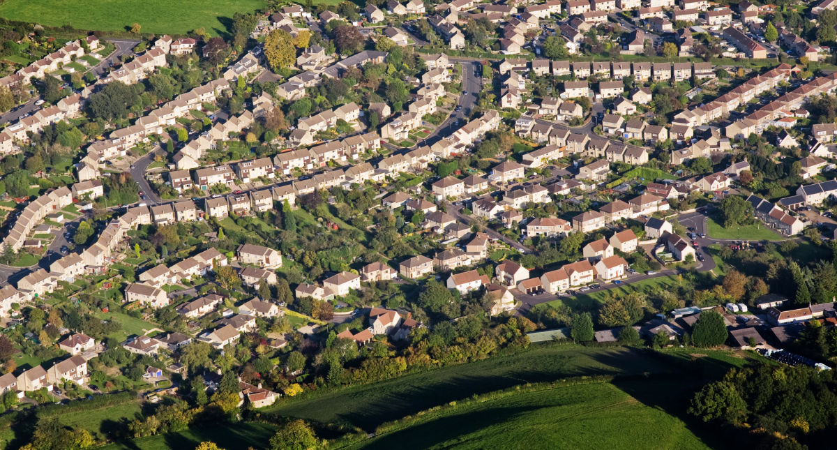
GreenSquare Group
Esri was the clear winner on all fronts. ArcGIS works with any type of data, there is an extensive user community plus the price was highly competitive
Having recognised that 90% of its business data was geographical, GreenSquare Group made the decision to deploy Esri’s ArcGIS platform to consolidate and visualise information throughout its entire organisation. The benefits achieved span simple operational, cost-saving gains to supporting major strategic decisions such as identifying significant new opportunities to expand its housing portfolio.
The Customer
GreenSquare Group is a major provider of housing, regeneration, care and support and commercial services across Wiltshire, Oxfordshire and Gloucestershire. Managing 10,000 properties for social and affordable rent, and offering homes for sale, the group also works with Kevin McCloud’s company Hab on innovative eco-housing projects.
GIS analysis has revealed several new sites for development, for which the potential land value is approximately £2 million
Employees can perform feasibility studies for new developments in just two days, eight days more quickly than beforehand
Maintenance activities are planned more strategically by location, to help improve cost efficiencies across the business
The Challenge
GreenSquare had a long-term vision for GIS that would positively impact the whole organisation. It wanted to use the technology to join together all departments and deliver benefits across the business, in areas such as development and regeneration, disposals, welfare reform, rent arrears, anti-social behaviour, tenant profiling and maintenance.
“To deliver our long-term strategy we wanted a more powerful GIS, one that was proven in the industry and at the right price,” explained Dawn Francis, Group GIS Manager at GreenSquare. “Part of the GIS vision was that around 90% of data within the group was geographical and should be mapped. This holistic approach to using our data more intelligently would allow us to be more strategic in how we operated.”
GreenSquare’s board members are also keen to support innovative ways to improve the business or overcome new challenges and were enthusiastic to see how GIS could help.
Esri was the clear winner on all fronts. ArcGIS could work with any type of data, the company had an extensive user community plus the price was highly competitive
Dawn Francis – Group GIS Manager, GreenSquare Group
The Solution
Following an in-depth tender process, GreenSquare selected Esri UK’s ArcGIS as its new GIS platform. “Esri was the clear winner on all fronts,” commented Dawn. “ArcGIS could work with any type of data, the company had an extensive user community plus the price was highly competitive.”
In order to get the most out of the new GIS, GreenSquare first spent around five months data cleansing their information. This involved re-evaluating all geo-codes for 3,000 flats and dispersing the markers so it could see each individual property within multi-storey blocks. “To function strategically, we first needed to disperse the markers to achieve a more granular view of all our properties and see the attribute data linked to each flat,” said Dawn.
Coming from a Business Intelligence background, Dawn had a valuable insight into the type of business reports that could be visualised within the GIS. By applying this expertise, GreenSquare has been able to deliver new levels of location intelligence across the company.
Esri’s GIS has linked disparate business units, allowing for a better co-ordination of how we do business. The benefits achieved span simple operational gains to supporting major strategic decisions
Dawn Francis – Group GIS Manager, GreenSquare Group
The Benefits
The main benefit for GreenSquare has come from bringing together disparate types of information in the GIS and visualising them in one place. “Being able to toggle between multiple data streams on the same map has opened up endless opportunities to interrogate the data and spot new insights,” said Dawn.
GIS is already helping drive the development pipeline, which has a target of building 30 new units a year on existing land under its ownership. By overlaying property types, access routes, who owns what land, where demand for housing is and many other factors needed for an initial investigation, GreenSquare has been able to reveal several new sites for development. So far, the potential value of this land is approximately £2m.
“Using the GIS we can switch different types of information on and off, to ask questions relating to a location, arriving at a decision about its suitability for development, conversion or regeneration,” said Dawn. “Efficiently evaluating and unlocking development land will lead to additional income from new homes for sale and rent from land holdings.” commented Dawn. “This was previously labour intensive using spreadsheets or disparate maps. To operate strategically you have to bring your data to life with interactive maps.”
Major efficiency gains are also being achieved via the new GIS. Feasibility studies for new development sites which used to take 10 days have been cut to two days, while the property disposal process has been reduced from four days per month to around three hours. “The GIS has removed a lot of site visits, physical meetings and manual hard copy processes,” added Dawn. “All the necessary information is available online in the GIS and is being used by all staff, right up to the board.”
The GIS is also making it easier to manage maintenance more efficiently. In the past, planned maintenance programmes were scheduled according to alphabetical road order. But this meant homes in streets nearby might have had work done months apart, when it made more sense to carry out the work at the same time. Now maintenance schedules can be seen on a map and planned in the GIS, allowing better allocation of resources.
Future plans at GreenSquare include the introduction of real-time maintenance scheduling via mobile GIS on handheld devices, to minimise mileage and maximise efficiencies. Some GIS services will also become external so tenants can go online and find information for themselves to enhance customer service.
“Esri’s GIS has linked disparate business units, allowing for a better co-ordination of how we do business,” concluded Dawn. “The benefits achieved span simple operational gains to supporting major strategic decisions. By using location information in an intelligent way, GreenSquare is driving new revenue streams and injecting new levels of operational efficiency into the business.”

Ipswich Hospital NHS Trust
This project has changed the conversation at board level to focus on moving to a more sophisticated way of visualising and reporting data
In a pioneering NHS project, Ipswich Hospital NHS Trust has used Esri’s ArcGIS platform to help better understand demand for its services amongst the local population. The insight gained will help it to adapt resources to meet anticipated needs, as well as conduct health education campaigns targeted to the areas that need them most.
The Customer
Ipswich Hospital NHS Trust (IHT) provides healthcare services to more than 356,000 people throughout the local area. One of the hospital’s key objectives is to move to the centre of a network of co-located and integrated services, delivered to meet demand for healthcare across the region as well as driving education and research. It’s an ambitious goal, but to meet it IHT needs to map out where that demand is coming from.
ArcGIS, in conjunction with actuarial analysis, gives Ipswich Hospital NHS Trust faster time to insight about the needs of the population in its catchment areas
The Trust can use this insight to focus its resources on the departments and times when they will be needed most, reducing wastage
Hot spot maps show where key health issues are most prevalent, so the Trust can target health awareness campaigns in these specific localities
The Challenge
With over 75,000 emergency department attendances a year and nearly 30,000 unplanned emergency admissions, IHT, like many healthcare providers across the UK, faces tough challenges in managing the demand for its services. The provision of healthcare is an essential service and an emotive topic, so it is crucial that it can predict demand across the population and respond by meeting it quickly. To do that, ‘visualising’ the challenge it faces can drive real insight and, ultimately, lead to a better provision of service for the people it serves.
According to Paul Scott, Director of Finance and Performance at the Ipswich Hospital Trust (IHT), “our existing information solutions rely on extensive use of spreadsheets. They are therefore simply unable to provide us with the level of insight into patterns of behaviour in core populations that we urgently need. So, we decided to seek out a solution that would give us greater insight into where demand is coming from, within our catchment areas, and what form that demand will take.”
Currently, the escalating demand faced by the hospital’s A&E department continues to ramp up financial pressures on the IHT system. This is making it all but impossible to efficiently manage patient flows. Increasingly too, there is a knock-on effect on inpatients and outpatients’ departments and the wider care flow pathway.
The challenge facing the hospital is made more difficult by the need to meet tough key performance indicator (KPI) metrics, including keeping waiting times below four hours. In tackling these challenges, IHT has the following priorities:
- Improving clinical outcomes
- Overcoming financial challenges and making savings, critical in light of potentially failing to meet KPIs
- Making systems more efficient.
It is crucial that [Ipswich Hospital NHS Trust] can predict demand across the population and respond by meeting it quickly. To do that, ‘visualising’ the challenge it faces can drive real insight and, ultimately, lead to a better provision of service for the people it serves
The Solution
Not only did IHT need an objective understanding of current demand, but also needed to know how to intervene more effectively, in the future. It decided to implement a feasibility programme to assess how location analysis and actuarial analysis, working together, could provide insight into demand management that could shape future services for the better. Working with an actuarial services provider, who provided analysis into financial trends and risk, Esri UK delivered the location analytics solution to turn this vision into a reality.
The solution provides IHT with a combination of insight from Esri’s geographical information systems (GIS) and location analytics technology and high-quality clinical and financial data analysis, feeding into long-term financial modelling, provided by the actuarial service provider.
Esri UK’s location analytics solution was vitally important in delivering data visualisation to provide the required insight. Utilising the ArcGIS platform on IHT’s infrastructure on-premise, behind a secure firewall, ArcGIS for Server and ArcGIS for Desktop were deployed to provide services to a management insight dashboard.
IHT gains additional insight by being able to map out the number of cases going to A&E by a range of variables. The information is visualised as a hotspot analysis for example, highlighting the source of demand. The dashboard also provides a set of Key Performance Indicator (KPI) reporting tools, giving managers a dramatically improved understanding of the status of demand in the hospital by enabling them to break down A&E attendees by number of cases, average waiting time or mode of travel, and then split the figures down by timeframes.
[This project] has given us a whole new platform for discussion and changed the conversation at board level to focus on moving to a more sophisticated way of visualising and reporting data. The IHT board has even requested that geographic information and location is included within its business intelligence strategy
Paul Scott – Director of Finance and Performance at the Ipswich Hospital Trust
The Benefits
IHT recognises the huge potential of the system to achieve faster time to insight. Visualising data in a map format helps IHT understand where the hotspots are for certain diseases, admission methods and average time to treatment.
Understanding where demand comes from into emergency admissions, and the type and level of that demand, has allowed IHT to pinpoint areas of intervention to mitigate it.
The hospital believes this will enable it to improve its resourcing processes. It will be able to bring in more clinical support staff to meet increased demand on certain days of the week, for example, and therefore alleviate resource pressure. This could help minimise costs while maintaining performance and clinical standards.
According to Scott, “while this remains an R&D project it has highlighted a different way of looking at our organisation, and the demand pressures we face. In addition, it has demonstrated the huge potential of looking at demand from a population rather than individual attendance basis.”
“It also allows us to try out ‘what if’ scenarios. In short, it has given us a whole new platform for discussion and changed the conversation at board level to focus on moving to a more sophisticated way of visualising and reporting data. The IHT board has even requested that geographic information and location is included within its business intelligence strategy.”
Moving forward, the outputs from patient demand analysis, mapping insights and possible interventions could provide a basis for service reconfiguration and therefore wastage reductions.
The use of GIS information, in particular in conjunction with actuarial, could put IHT ahead of other National Health Service Trusts in terms of innovative use of IT in healthcare provision.
Moreover this exciting, ground-breaking project has the potential to revolutionise the future of healthcare demand management, not just in Ipswich but across the whole of the UK.