The ArcGIS Living Atlas of the World is a collection of geographic information from around the world and includes content contributions from some of the UK’s most recognisable organisations. This collection of spatial data sits at the heart of the ArcGIS System, helping to support your work by providing authoritative and easy to access maps, apps and data layers.
We are delighted to have recently welcomed three datasets from the British Geological Survey (BGS) to the ArcGIS Living Atlas. In addition to being a world-leading geological survey and global geoscience organisation, the BGS is the UK’s premier provider of authoritative geoscientific data. The addition of UK Modern Earthquakes, UK Historical Earthquakes and GB Single Onshore Borehole Index (SOBI) datasets means that it’s now easier than ever to use British geological data within the ArcGIS System.
Let’s take a look at these datasets and explore some of the potential ways in which they could be used.
Exploring the datasets
First off, we’ll start with the UK Modern Earthquakes dataset, which shows the location of all earthquakes recorded within the UK from 1956 up to the present day. The data has been captured using the BGS’ high-sensitivity monitoring network, which consists of 50 stations and allows earthquakes as small as magnitude 2.0 to be detected. The dataset contains useful data fields, including earthquake depth, Richter local magnitude and EMS intensity. In the animation below, I explored the data in the new Map Viewer using the time slider function.
Using the time slider to explore the UK Modern Earthquakes dataset in the new Map Viewer
Next up is the UK Historical Earthquakes dataset. This shows the location of historical earthquakes within the UK, which has been compiled using macroseismic observations i.e. felt effects. The events recorded in this dataset span from 1382 up until 1970 and the data includes earthquake depth, Richter local magnitude, EMS intensity and the magnitude determined from the felt area of the earthquake. This dataset is fantastic for understanding how recent earthquakes compare with historical events.
Lastly, we have the GB Single Onshore Borehole Index (SOBI). This is an index containing over one million records of boreholes, shafts and wells that have been gathered during drilling and site investigation work carried out by the BGS. The data contained within the index dates back as far as 1790, with around 50,000 new boreholes being added each year. The index contains both onshore and near shore boreholes, with depths ranging from one to several thousand metres. The majority of boreholes also contain a link to a scan of the borehole record held by the BGS, which contains more detailed location and lithological descriptions using the geologist’s/surveyor’s observations.
Using the data
I’ve really enjoyed exploring these datasets, so I thought I would share with you just a couple of possible use cases.
Understanding latest earthquake activity:
The UK Modern Earthquakes dataset offers a great way to understand when and where earthquakes occur within the UK. This can be done by using a range of apps that are available as part of the ArcGIS System. In the below example, I’ve taken advantage of the ability to use Arcade within ArcGIS Dashboards to show the number of earthquakes that have recently occurred within the UK and their characteristics. The dashboard allows users to explore the data to understand trends in recent UK earthquake activity.
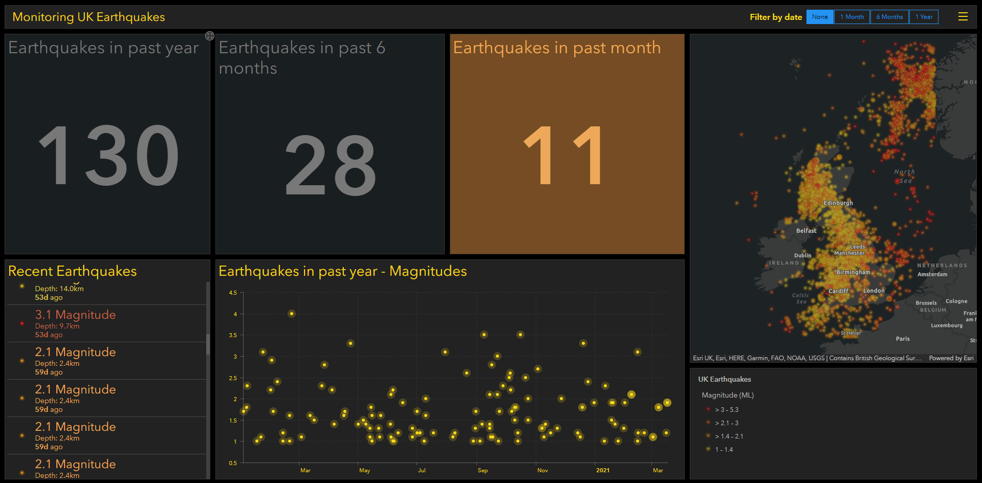
Exploring UK earthquakes using an ArcGIS Dashboard configured with Arcade for additional insights
Site Investigations:
Site investigations are a useful way of learning as much as possible about the geology of a site to help make informed decisions. You can use the GB Single Onshore Borehole Index (SOBI) dataset to undertake desktop site investigations by viewing located boreholes on a map and exploring the data included with each record. This includes a link through to scans of the borehole record held by the BGS, allowing users to view the observations that were recorded when the borehole was created. In the example below, I was able to use ArcGIS Pro to explore the data and view scanned borehole records.
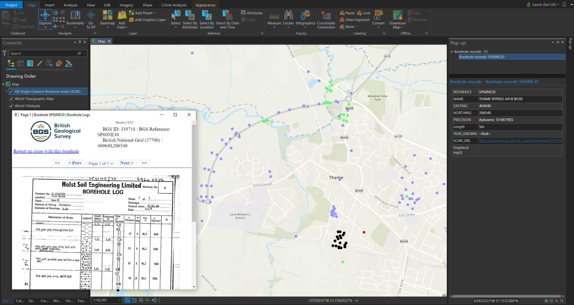
Viewing and exploring the GB Single Onshore Borehole Index (SOBI) within ArcGIS Pro
Alternatively, the same data can also be accessed using ArcGIS Field Maps, allowing you to access Borehole Index data on a mobile device whilst out in the field.
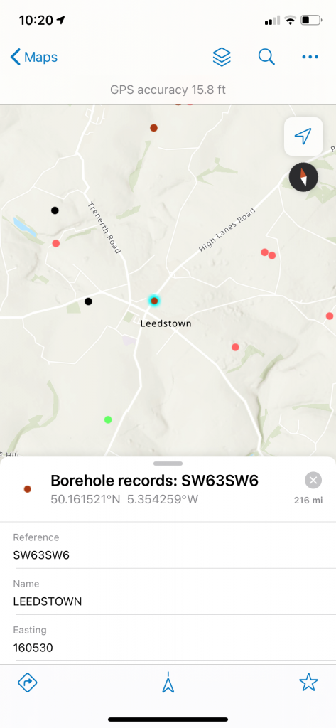
Viewing and exploring the GB Single Onshore Borehole Index (SOBI) using ArcGIS Field Maps
We’re really excited to welcome these datasets from the British Geological Survey to the ArcGIS Living Atlas, and I hope I’ve been able to show how you could make the most of this data. The ArcGIS Living Atlas is a fantastic collection of global datasets, so next time you are working with the ArcGIS System I would strongly encourage you to explore the datasets. It might help enhance your analysis and provide additional spatial context.
If you have a dataset of your own that you would be interested in nominating to the ArcGIS Living Atlas for use by the GIS community, you can do so from within the ArcGIS Living Atlas Website or alternatively you can contact us directly on datacurator@esriuk.com.