For this Q3 update, we have welcomed 26 new datasets and 3 new contributors to Living Atlas – Met Office, Rural Payments Agency and Digital Health and Care Wales! As of today, UK Living Atlas has 632 items and 57 Contributors – let’s explore some of these new additions.
Environment
Understand how climate change will affect your area with data from the Met Office
After sharing 18 of their climate datasets to Living Atlas, the Met Office is now a data contributor. These contributions include Monthly Precipitation Projections 2050-2079, Monthly Temperature Projections 2050-2079, Time-mean Sea Level Projections to 2100 and much more. Find out how climate change will impact your local area here.
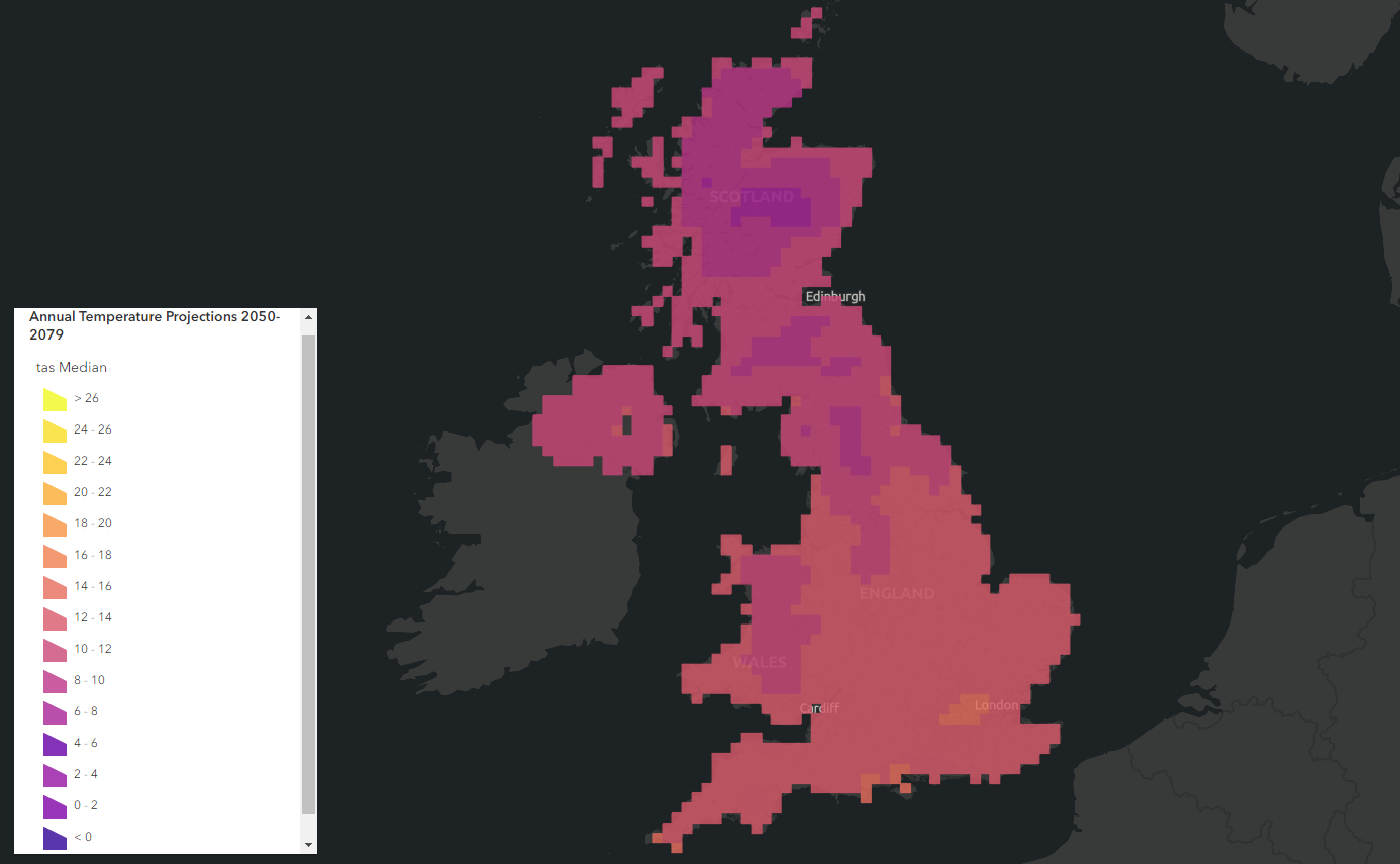
Annual temperature projections 2050-2079 from the Met Office.
All this data is from the Met Office’s Climate Data Portal. Here, they also provide user guides on how to use their data and a whole host of useful resources.
Discover the cropland in England with Rural Payments Agency’s Crop Map of England (2021)
We are pleased to welcome the Rural Payments Agency to Living Atlas’ network of contributors after sharing their Crop Map of England (CROME) 2021. This dataset classifies England into 15+ main crop types, grassland, and non-agricultural land covers.
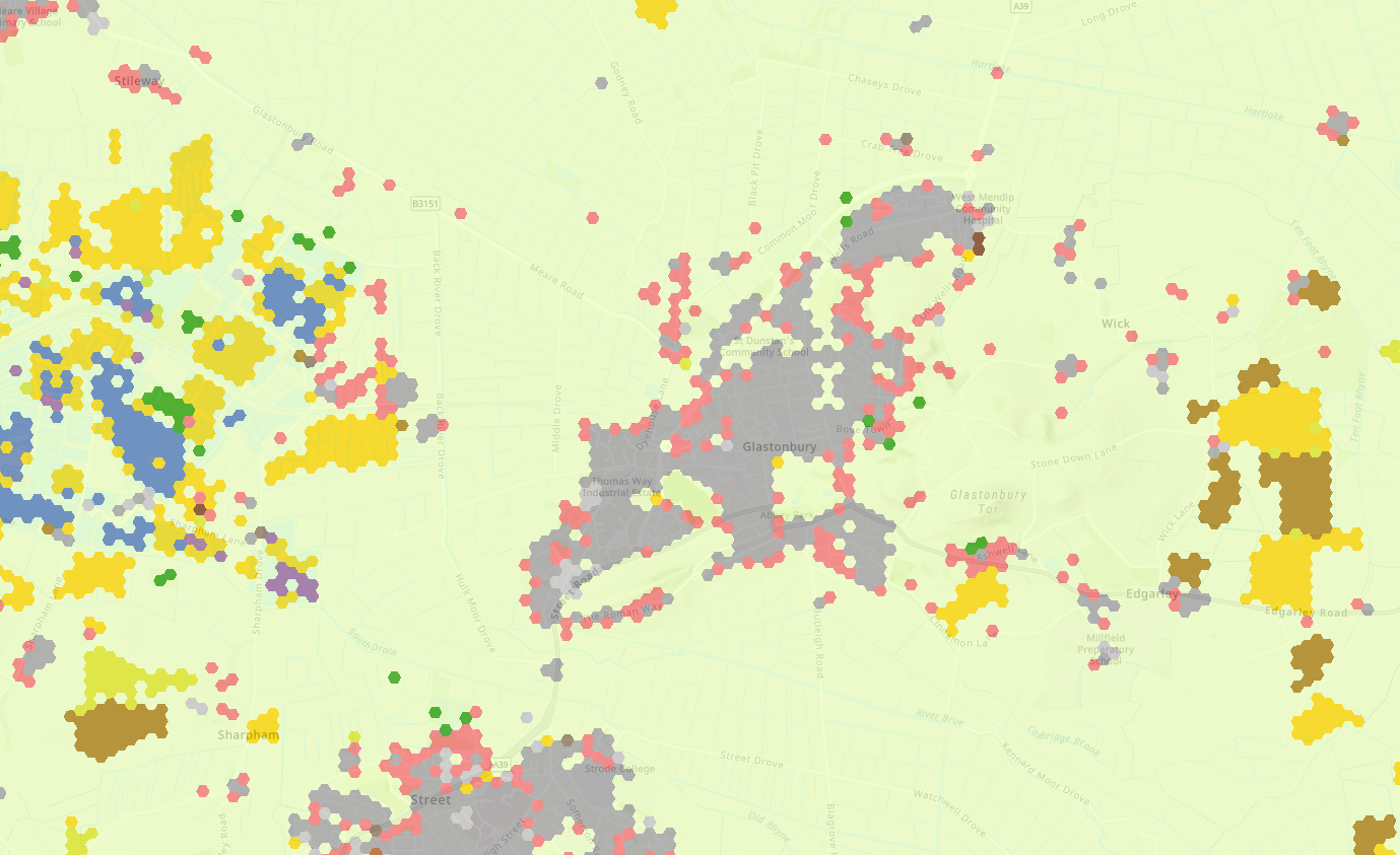
Crop Map of England 2021 from the Environment Agency showing Glastonbury.
Containing approximately 32 million hexagonal cells, the supervised classification was created using Sentinel-1 Radar and Sentinel-2 Optical Satellite images during October 2020 – September 2021. Embed this in your maps to improve your understanding of the crop types in England and why not combine it with other land cover data available in Living Atlas?
Explore UK’s geology with the British Geological Survey
British Geological Survey add to their Living Atlas collection by contributing their 625k UK Geology dataset. This has been shared as a feature layer and an interactive Dashboard.
The feature layer depicts Bedrock Geology, Superficial Geology and Linear features (faults). The Dashboard illustrates the distribution of bedrock geology using various graphics and charts. It is fully interactive to allow you to explore the data.
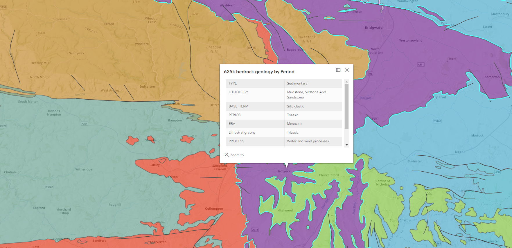
British Geological Survey 625K data
Use this to understand more about UK geology, such as: what the rocks are made of, when they were formed, by what processes, and in what type of environment. Check out this blog to learn more about how you can use this geology data in your maps and projects.
Assess the conditions of peatlands with Natural England
Natural England have contributed their Moorland Deep Peat AP Status data. This dataset displays the location of Deep Peaty Soils and their condition. This data can be used to improve the understanding, management, and restoration of peatlands.
The Peat Layer was produced by Natural England during June – October 2008 to identify the extent of three classes of peaty soils. This was completed for the Partnership Project to Protect and Enhance Peat Soils, also known as the Peat Project.
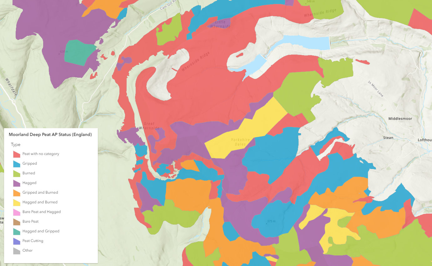
Moorland Deep Peat status from Natural England.
Natural England’s tool to analyse the risks posed by development proposals
Natural England have also shared their SSSI Impact Risk Zones. This is a tool used to make rapid initial assessments of the potential risks posed by development proposals to: Sites of Special Scientific Interest (SSSIs), Special Areas of Conservation (SACs), Special Protection Areas (SPAs) and Ramsar sites.
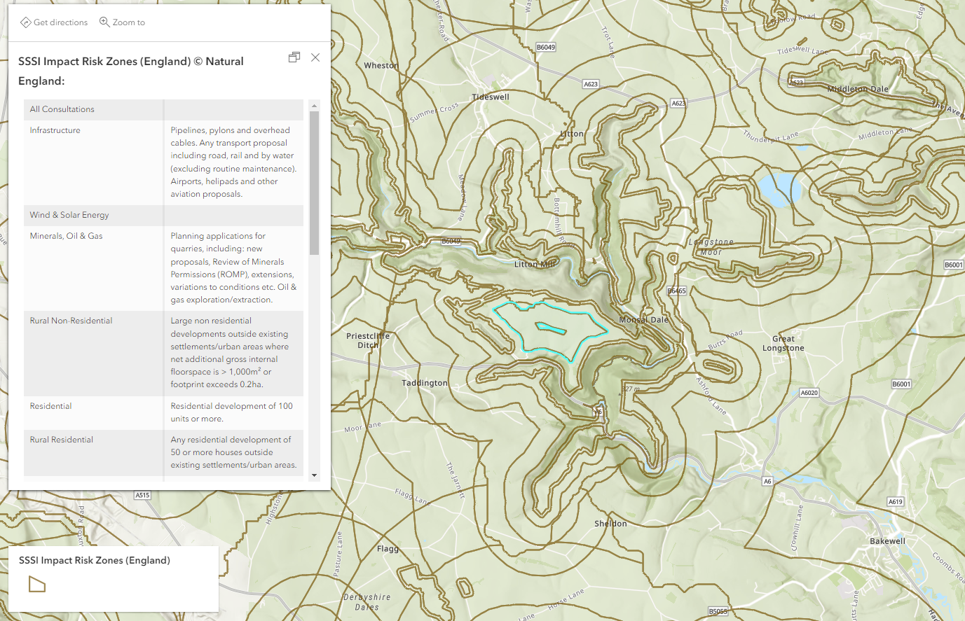
Impact Risk Zones from Natural England.
Local Planning Authorities can use this data to analyse the potential impacts of development and determine whether Natural England should be consulted for advice to reduce these impacts.
People
Explore the fertility rate in Wales with Digital Health and Care Wales
Digital Health and Care Wales are also a new Living Atlas contributor as they have shared General Fertility Rate by Local Health Board in Wales.
General Fertility Rate is calculated as the number of live births per 1,000 females aged 15-44. This data is sourced from the Office for National Statistics and will be updated annually. The rates are currently available for the years 2012-2020.
Tracking fertility rates allows for more efficient planning and resource allocation in an area. Combine this data with Welsh Index of Multiple Deprivation data from the Welsh Government to leverage your demographic analysis.
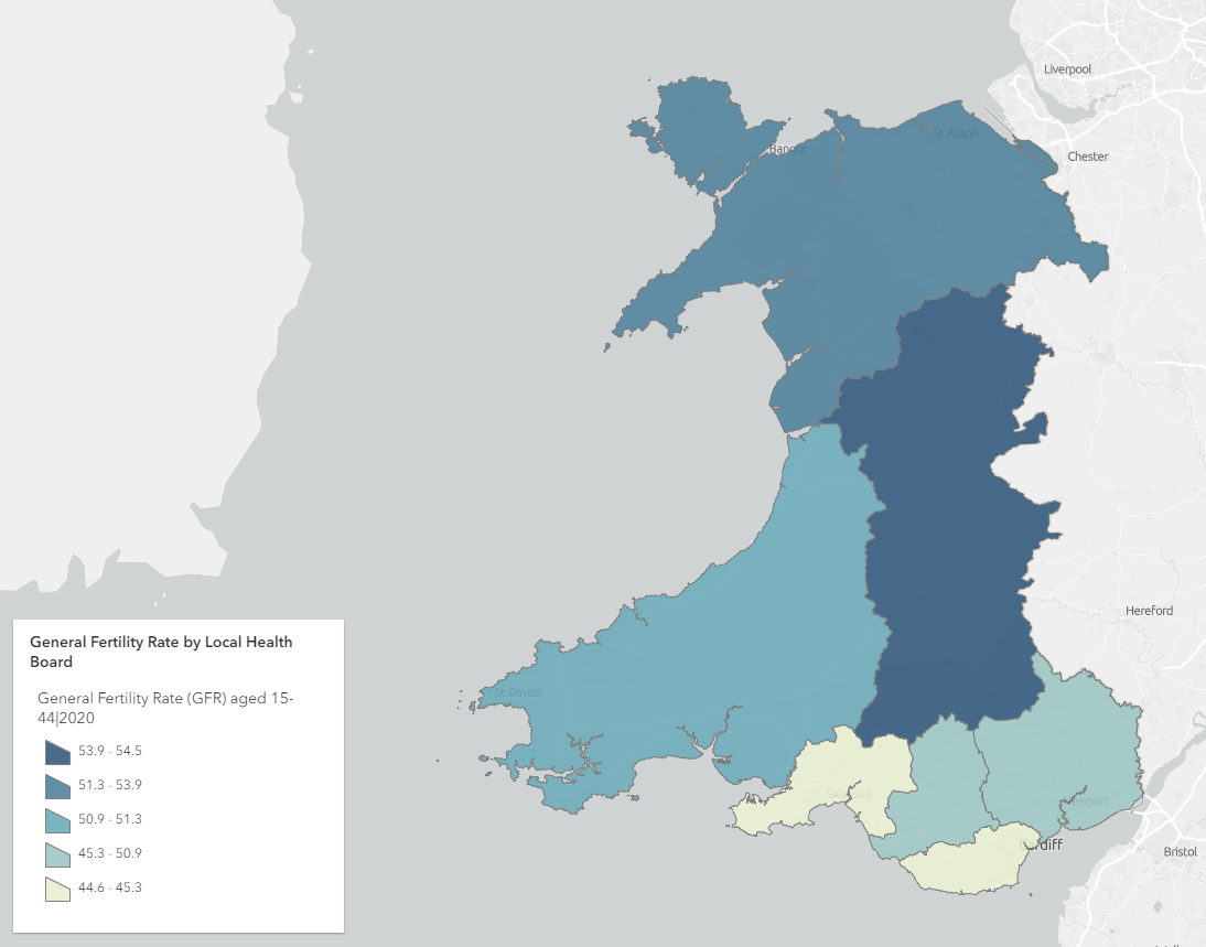
General Fertility Rate for Wales from Digital Health and Care Wales.
Enhance your demographic analysis with the Census 2021 Population Summary curated by Esri UK
The 2021 Census data is being curated by Esri UK as part of our National Data Service offering. The first release Census data is now also available in Living Atlas.
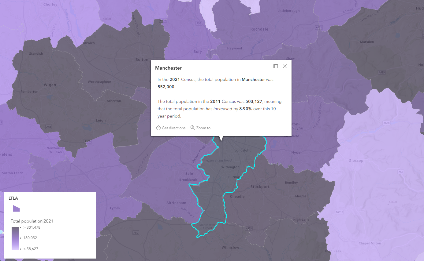
Population summary for England and Wales in the first release Census.
This release shows population and household data for England and Wales and are broken down into 140 separate indicators by sex, broad age group and 5-year age group. There are also comparisons with the closest equivalent data selected for the 2011, 2001 and 1991 censuses to show change over time in the headline data.
This is the first of several releases of Census data that Esri UK will be making available. The National Data Service delivers thousands of open national statistical indicators for the UK at custom geographies as data-as-a-service. Read more about it here.
Census 2021 data available in Living Atlas and National Data Service.
Boundaries
Find out the rural and urban classifications in Wales
Digital Health and Care Wales have also added the 2011 rural-urban classification for Wales. Rural-Urban classification allows for the consistent rural/urban view of datasets. This dataset classifies them by Lower Super Output Area (LSOA).
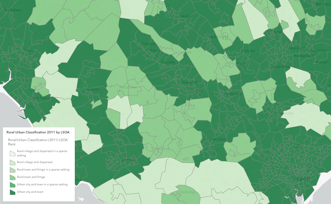
Rural-Urban classification in Wales from the Welsh Government
There is now Rural-Urban classification for Wales and Scotland available Living Atlas.
Basemaps
Use beta Living Atlas basemaps in your work
Living Atlas basemaps are updated frequently and continue to evolve. The latest additions are released under beta and are not part of the default Esri basemap gallery or discoverable in Living Atlas. However, you can still use beta Living Atlas beta basemaps in your maps and projects if you wish.
Living Atlas beta basemaps available for general use.
If you want to create a custom basemap gallery for your organisation using Living Atlas data, read this blog.
Living Atlas UK Dashboard
ArcGIS Living Atlas of the World continues to see new contributors and datasets each month. To help keep you up to date with all the different content available in the Living Atlas, I have created this interactive Living Atlas UK dashboard.
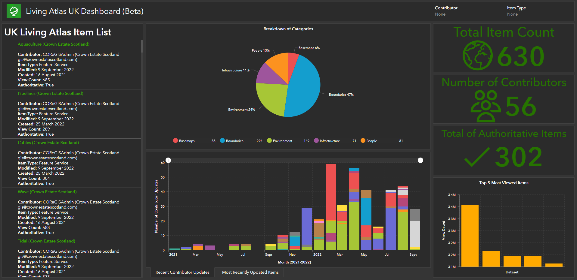
Living Atlas UK Dashboard to help users explore what’s in Living Atlas and who has contributed.
The dashboard is fully interactive and is updated on a weekly basis. It is currently in Beta release so if you have any feedback on what other metrics you would like to see, please reach out to DataCurator@esriuk.com.
General Living Atlas Updates
All GB Basemaps and OS Open Data have now been updated. The currency of the data is the latest version (April 2022). The next planned updates will be in October/November.
Living Atlas Resources
Want to find out more about Living Atlas, how to use the data, how to contribute your data and much more? Check out this ArcGIS Online group for resources.
Check out this blog uses land cover data in Living Atlas to find out what your city is made of.
This blog answers Living Atlas FAQs from the Esri User Conference.
Share your organisation’s data to Living Atlas
See what Sustrans and Crown Estate Scotland have to say about contributing their data to Living Atlas.
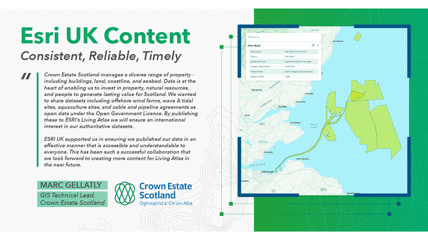
Statement from Crown Estate Scotland and Sustrans about their experience of contributing data to Living Atlas.
If your organisation has authoritative datasets that would be a valuable addition to the platform, contribute them to Living Atlas and you too can be featured in the next blog. Find out how in this StoryMap.
For any ArcGIS Living Atlas queries, please get in touch with DataCurator@esriuk.com.
Now you’re up to date…
Why not visit the ArcGIS Living Atlas of the World to explore the thousands of authoritative content at your fingertips?
To keep up to date with other ArcGIS Living Atlas news, check out Esri’s blog and follow our dedicated Twitter account. Join Esri Community to connect with other ArcGIS Living Atlas users and share ideas, solutions and collaborate to solve problems with GIS.