Tag Archives: ArcGIS Enterprise

The Crown Estate
Automated geospatial analysis conducted with ArcGIS provides the evidence we need to inform the future of marine environments up to 2050.
Continue Reading
CBRE
ArcGIS has always been a vital tool for our business. We utilised the capabilities of ArcGIS Enterprise 11.1 to redevelop DataViz, our centralised platform to visualise and analyse geospatial data, helping to provide an even swifter service for our clients.
Continue ReadingEnabling Mobile Working with ArcGIS
This blog was updated in June 2025 to reflect new changes to the Mobile Worker user type. If you or your organisation are looking to collect and engage with your own geospatial data, you’ve come to the right place. Say … Continue reading
Continue Reading
Greater London Authority
Web mapping services created with ArcGIS Enterprise allow us to make 3,500 datasets from 35 organisations available internally and publicly in a standardised and discoverable format.
Continue Reading
Cornwall Council
A series of ArcGIS Field Maps apps, built in-house, are helping us to manage and expand our trees and forestry more cost effectively.
Continue ReadingPowerful apps in an instant with ArcGIS Instant Apps
If you’re reading this, I’m going to assume you’ve made a map or two in the past to help visualise your data with geographical context. But what if you want to share this with others so they can interact, better … Continue reading
Continue Reading
AtkinsRéalis
We are using ArcGIS Portal, ArcGIS Pro and ArcGIS Field Maps to drive the AtkinsRéalis SpatialCDE, used by multiple stakeholders to make construction projects more efficient while driving Biodiversity Net Gain.
Continue Reading
Thames Water
We are proactively addressing the data sharing requirements, and the needs of internal and external stakeholders with our end-to-end geospatial portal, built with ArcGIS Enterprise and ArcGIS Online.
Continue Reading
Getting to grips with ArcGIS Connectors for Power Automate
ArcGIS Survey123 users have had the ability to enhance their workflows through automation for some time now, using connectors available in Power Automate and Make (formally Integromat). If you wanted to configure automated post-capture workflows for your other applications, there … Continue reading
Continue Reading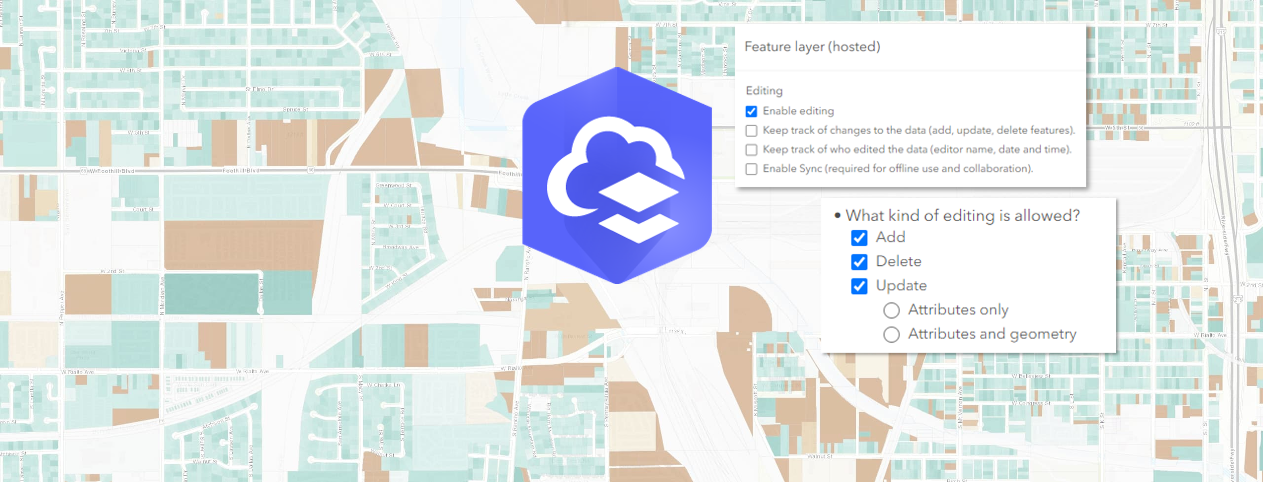
Web-editing in ArcGIS: learn to easily manage feature layer edits
Create polygons for building outlines. Update attributes for utility networks. Delete outdated bird spotting points from your wildlife watcher’s map (or feel free to insert your own oddly specific example to further progress this introduction). Whatever the case, editing in … Continue reading
Continue Reading