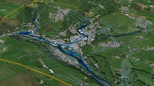
Blog Esri UK Tech BlogCategorySelect3DCartographyContentData ManagementDeveloperMobileProduct NewsSpatial AnalysisTipsTechnologySelectAppsArcadeArcGIS EnterpriseArcGIS Living AtlasArcGIS OnlineArcGIS ProArcGIS StoryMapsDevelopersMobileSweet for ArcGISUK ProductsUtility Network EditorSearch Tips Let your work flow with tasks in ArcGIS Pro 16th December 2022 While I was creating my Electric Vehicle charge maps, I realised that I had developed a workflow in ArcGIS Pro that could be repeated for any highway in Britain. A colleague suggested that I try recording and sharing my workflow … Read more Tips Cartographic representations in ArcGIS Pro 21st November 2022 Many of you will have made the switch from ArcMap to ArcGIS Pro already, but you may still need to move ArcMap content to the new ArcGIS Pro projects. So – what needs to happen if you want to start … Read more Cartography Mapping 100 years of precipitation 18th November 2022 In the UK, the 10 hottest years on record have all been since 2002 and in the summer of 2022, July and August were the warmest ever. Despite periods of rainfall, hosepipe bans were put in place across large areas … Read more Spatial Analysis Taking a spatial-first approach to the location of assets 3rd November 2022 In this blog post I’ll discuss the relative benefits of linear referencing and spatial referencing. I’ll cover where each can have its place, which should be considered the master, and why. What is linear referencing? In many industries such as &h... Read more Tips From project to paper: printing in the ArcGIS System 3rd November 2022 The world is becoming more and more digital. We’re no strangers to it at Esri UK, providing ways for people to create interactive apps, maps and websites that don’t quite have the same effect when printed onto traditional, static paper. … <... Read more Cartography Watermarkr your map 7th October 2022 With the retirement of Markr coming ever closer, you may be wondering “how can I add watermarks to my map?”. The answer is simple: all you need is an awesome logo in SVG format, a coverage layer in the coordinate … Read more Content OS Vector Tile API within ArcGIS 5th October 2022 You have been asking for a while how to use Ordnance Survey’s Vector Tile API within ArcGIS. Whilst it has always been possible to use them in applications you build with the ArcGIS APIs and SDKs, some recent updates to … Read more Tips Improving colour blindness accessibility in ArcGIS Pro 5th September 2022 There are an estimated 300 million people globally who suffer with colour vision deficiency (CVD), equating to 8% of the male population and 0.4% of the female population. Easily distinguishable colours such as red, green and blue, can appear extr... Read more Tips Engineering a better understanding of crime data in ArcGIS Pro 16th August 2022 In ArcGIS Pro you can now cluster point features to simplify data visualisation. Each cluster represents two or more features in the dataset, and by default, a text marker displays on top of the cluster to communicate the number of … Read more Spatial Analysis Transform pixels into information using ArcGIS 3rd May 2022 Over the last 10 years or so, imagery has been more widely adopted as part of an organisation’s set of core datasets. This is due partly to the decreasing costs of sourcing the imagery and the increasing availability of imagery, … Read more Cartography Label maps, not each other 25th February 2022 Good map design can provide that all important link between functionality and aesthetics. While there is more to cartography than dressing a map up, if a map attracts a reader’s attention through its visual appeal, they will naturally be more &hel... Read more Spatial Analysis Time Series Forecasting for Non-Statisticians 15th February 2022 Time series forecasting – what is it, why would I use it, and how can I get started? In this blog, I’ll be taking you through the ‘what, why, and how’ of time series forecasting with ArcGIS Pro and how … Read more Pages: 1234567Load More