Blog Esri UK Tech Blog CategorySelect3DCartographyContentData ManagementDeveloperMobileProduct NewsSpatial AnalysisTipsTechnologySelectAppsArcadeArcGIS EnterpriseArcGIS Experience BuilderArcGIS Living AtlasArcGIS OnlineArcGIS ProArcGIS StoryMapsDevelopersMobileReport Builder for ArcGISSweet for ArcGISUK ProductsUtility Network EditorSearch Cartography How many people can you really fit on a beach? 3rd July 2020 With swarms of crowds heading to the beach, we asked ourselves ‘how many people can you really fit on the beach, at a safe social distance?’ The answer: a lot less than the current crowds! This blog will outline the … Read more Content How we made the Pavements Width map 11th June 2020 Esri UK have recently published a dataset focusing on pavement widths across GB. This has given the Local Authorities the opportunity to better prepare for social distancing measures over the coming months. It was also featured in recent article i... Read more Cartography How close is your local park? 4th June 2020 During the Great Lockdown of 2020, we’ve all had to re-familiarise ourselves with the local area surrounding our homes. Forcing us to explore the local parks and hidden bridleways you perhaps didn’t know existed before the pandemic. This sparked a... Read more Tips Making maps with ArcGIS Online – an introduction 31st March 2020 ArcGIS Online underpins the software and assistance that Esri is providing to help organisations worldwide tackle the Coronavirus pandemic. I’ve put this blog post together to provide a quick introduction to getting started with ArcGIS Online - on... Read more Cartography 
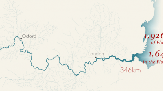
The UK’s Longest Rivers 22nd March 2020 
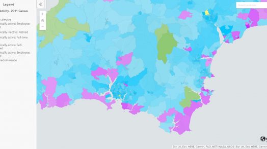
Extreme weather events are becoming more common, more unpredictable and more severe. This is apparent all around the world. The flood events in the UK this winter forced many people to evacuate their homes. With World Water Day 2020 &hellip... Read more Cartography About bushfires, satellites and oil rigs 24th January 2020 Over-sized fire symbols, misleading colours and poorly selected projections have all been front and centre in the recent spread of bushfire maps. Following yet another deadly bushfire event, a wide variety of maps have been created to reflect the ... Read more Cartography Eleven ways to map a General Election 6th December 2019 It’s that time again; on 12th December, people across the nation will cast their votes to decide who will be the United Kingdom’s Prime Minister. Elections offer plenty of opportunities when it comes to mapping results, so I’ve been using …... Read more 3D Mapping the Moon 19th July 2019 In celebration of the 50th anniversary of the Apollo 11 mission, we've mapped the Moon in 3D. Interested in how we made it? Read on to find out how… Read more Cartography Mapping leisure choice in 30 minutes with OS Greenspace 11th July 2019 To celebrate the arrival of the Ordnance Survey Open Greenspace dataset to the ArcGIS Living Atlas a number of us at Esri UK took part in a 30 Minute Map competition. I decided to map leisure activities an... Read more Cartography Make your basemaps work for you – customising vector basemaps 21st June 2019 Basemaps come in a variety of types, styles and scales for you to choose from, from full detail to muted backgrounds, but have you ever wanted to change something about them? Find out how to make the most ... Read more Cartography What goes on in UK Waters? 13th June 2019 The UK hosts the world’s busiest shipping lanes. Do you know what goes on in our waters? Read more Cartography Marathon Magic: How to animate time in ArcGIS Pro 29th April 2019 Read on if you want to learn the magic behind making our London Marathon race map animation. Read more Pages: 1234Load More