Blog Esri UK Tech Blog CategorySelect3DCartographyContentData ManagementDeveloperMobileProduct NewsSpatial AnalysisTipsTechnologySelectAppsArcadeArcGIS EnterpriseArcGIS Experience BuilderArcGIS Living AtlasArcGIS OnlineArcGIS ProArcGIS StoryMapsDevelopersMobileReport Builder for ArcGISSweet for ArcGISUK ProductsUtility Network EditorSearch Cartography On the Map: Game of Thrones filming locations 12th April 2019 Inspired by the breath-taking scenery featured in the Game of Thrones, we’ve mapped all of the filming locations in our GoT themed map. Read on to see these locations in all their glory… Read more Cartography Where is the love? – Valentine’s Day Cartography 15th February 2019 Did you see our romantically-themed Valentine’s map? Read on to find out how we made it. Read more Cartography How clean is the air you breathe? 1st February 2019 Over 8 million people live in Greater London with roughly 11.9 million vehicles travelling their road’s in 2017. That’s a lot of vehicles emitting and a lot of people breathing. In the wake of the government’s new ... Read more Cartography Keeping it Simple: Road Layouts in ArcGIS Pro Layout 17th January 2019 Want to know how to create custom maps with ArcGIS Pro Layout? Or just find out where the other most complex road junctions across England are? Read more Cartography Visualising Brexit Isles 7th November 2018 Brexit has divided a nation politically. The esri UK Media Maps team put together a Brexit Isles visualisation to understand how the two nations would look geographically. Find out what inspired us and ho... Read more Cartography Revealing hidden communities: a guide to multivariate dot density maps 9th August 2018 This is a multivariate dot density map. The map reveals religious identity across London. Each person is represented by a single dot - the colour depicting religious allegiance. So how did I create it? Read more Cartography Visualising Lightning: an exercise in aggregating data 11th July 2018 I received some interesting data from the Met Office - lightning strike locations for the UK and Ireland. Given a new set of data there is a common process that I work through to arrive at the final map. Read more Cartography Learn about: ArcGIS Maps for Adobe Creative Cloud 4th July 2018 The ArcGIS Maps for Adobe Creative Cloud is an app that allows you to work with data-driven maps in Adobe Illustrator and Photoshop. From these you can create beautiful, data-driven maps in hours, not days. Read more 3D Tons of new features in ArcGIS Pro 2.2 27th June 2018 The latest update for ArcGIS Pro has now arrived. This most recent update has many new advances to put a spring in your step, and we don’t want you to miss out on these exciting features. Read more Cartography When a single map isn’t enough… 19th June 2018 
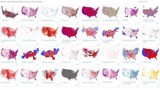
At our annual conference, Ken Field presented on thematic map design. Ken describes himself as a professional ‘cartonerd’ and is part of Esri’s cartography team, having moved to sunnier climes. For those of us tha... Read more Pages: 1234Load More