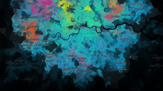
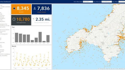
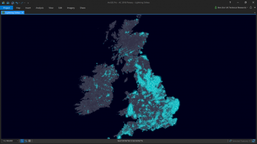
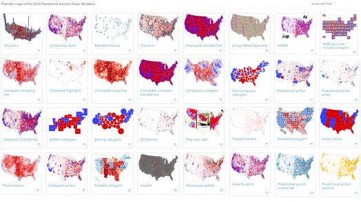
Blog Esri UK Tech Blog CategorySelect3DCartographyContentData ManagementDeveloperMobileProduct NewsSpatial AnalysisTipsTechnologySelectAppsArcadeArcGIS EnterpriseArcGIS Experience BuilderArcGIS Living AtlasArcGIS OnlineArcGIS ProArcGIS StoryMapsDevelopersMobileReport Builder for ArcGISSweet for ArcGISUK ProductsUtility Network EditorSearch Cartography Revealing hidden communities: a guide to multivariate dot density maps 9th August 2018 This is a multivariate dot density map. The map reveals religious identity across London. Each person is represented by a single dot - the colour depicting religious allegiance. So how did I create it? Read more Tips Pulling your brand into Esri Apps 27th July 2018 Esri apps have a default look and feel, but we often hear from users who want to re-style their apps to align with their organisations brand. **Spoiler alert** – you can, and it’s easy. Read more Content Accessing OS Open Zoomstack Vector Tiles in ArcGIS 20th July 2018 Building multiscale basemaps can be very challenging when you have to integrate different datasets into a consistent map base. OS have started an Open Zoomstack trial to explore ways to make this easier. One of ... Read more Content Inspiration to create your own Open Data site 17th July 2018 Many organisations use ArcGIS to share and work with Open Data. Creating an Open Data site using ArcGIS Hub is a great way to liberate your data so you can meet mandated transparency requirements and enable greate... Read more Cartography Visualising Lightning: an exercise in aggregating data 11th July 2018 I received some interesting data from the Met Office - lightning strike locations for the UK and Ireland. Given a new set of data there is a common process that I work through to arrive at the final map. Read more Tips Did you know: you can use custom HTML and CSS in Story Map Journal? 6th July 2018 The Story Map Journal template allows you to view and edit the HTML source for the narrative side panel. This gives you the ability to completely adjust how content in the side panel is presented. Read more Cartography Learn about: ArcGIS Maps for Adobe Creative Cloud 4th July 2018 The ArcGIS Maps for Adobe Creative Cloud is an app that allows you to work with data-driven maps in Adobe Illustrator and Photoshop. From these you can create beautiful, data-driven maps in hours, not days. Read more 3D Tons of new features in ArcGIS Pro 2.2 27th June 2018 The latest update for ArcGIS Pro has now arrived. This most recent update has many new advances to put a spring in your step, and we don’t want you to miss out on these exciting features. Read more Product News ArcGIS Online summer update adds a Companion 27th June 2018 The ArcGIS Online Update for June 2018 has arrived. There are many new features including an improved Organisation page, new smart mapping styles, authoritative items and the new ArcGIS Companion app. Read more Cartography When a single map isn’t enough… 19th June 2018 At our annual conference, Ken Field presented on thematic map design. Ken describes himself as a professional ‘cartonerd’ and is part of Esri’s cartography team, having moved to sunnier climes. For those of us tha... Read more Content RNLI launches an Open Data site! 14th June 2018 The Royal National Lifeboat Institution has launched an Open Data site and contributed to the Living Atlas. We showcased the power of using this Open Data at our Esri UK Annual conference last month. Find out how ... Read more Tips Using Azure AD with ArcGIS Enterprise 12th June 2018 Many organisations use an enterprise identity store such as Microsoft Active Directory with their ArcGIS portals to provide authentication and single-sign-on to ArcGIS. In this blog I show you how I configured Azu... Read more Pages: 123456789101112131415161718192021222324Load More