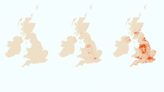
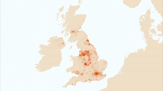
Blog Esri UK Tech Blog CategorySelect3DCartographyContentData ManagementDeveloperMobileProduct NewsSpatial AnalysisTipsTechnologySelectAppsArcadeArcGIS EnterpriseArcGIS Experience BuilderArcGIS Living AtlasArcGIS OnlineArcGIS ProArcGIS StoryMapsDevelopersMobileReport Builder for ArcGISSweet for ArcGISUK ProductsUtility Network EditorSearch Mobile ArcGIS Field Maps: destined to rationalise ArcGIS field apps 23rd June 2020 Starting with Collector for ArcGIS, we have got used to using focused apps to take GIS out of the office and into the field. To support and enhance the workflows, a family of apps has grown up alongside Collector: Explorer, … Read more Data Management How to use ArcGIS with Power BI 17th June 2020 Power BI is an excellent tool from Microsoft for data visualisation and dashboards. ArcGIS, from Esri, is also an excellent tool for data visualisation and dashboards. Can I use both? Absolutely. In fact, we encourage our customers to have both &h... Read more Content How we made the Pavements Width map 11th June 2020 Esri UK have recently published a dataset focusing on pavement widths across GB. This has given the Local Authorities the opportunity to better prepare for social distancing measures over the coming months. It was also featured in recent article i... Read more Data Management GEMINI 2.3 metadata in ArcGIS: an update 9th June 2020 Last September we explained how you should maintain GEMINI 2.3 metadata in ArcGIS. This new post provides more detail on these recommendations, as well as links to various tools and guidance. The AGI encourages you to maintain GEMINI metadata for ... Read more Cartography How close is your local park? 4th June 2020 During the Great Lockdown of 2020, we’ve all had to re-familiarise ourselves with the local area surrounding our homes. Forcing us to explore the local parks and hidden bridleways you perhaps didn’t know existed before the pandemic. This sparked a... Read more Mobile Essential reading for Survey123 admins 22nd May 2020 There’s no doubting the benefits and popularity of Survey123. The simple intuitive interface makes it a great tool for collecting data from different user groups and the ability to set surveys as public brings those benefits to citizen and custome... Read more Spatial Analysis Mapping Emissions Data from the Sentinel 5P Satellite 15th May 2020 The COVID-19 pandemic has lead to lockdowns across Europe changing how people live and work over the last few months. It has had a huge impact on society but one more positive story is that emissions around the world are being reduced, discussed i... Read more Data Management Using ArcGIS Online for managing sensitive COVID-19 related data in the UK 30th April 2020 There are many amazing examples of GIS being used to help understand and respond to the COVID-19 crisis. In the UK, hundreds of organisations are using ArcGIS Online’s cloud-based tools to manage, analyse and communicate key data related to the cr... Read more Product News ArcGIS Insights for COVID-19 Analytics 24th April 2020 The COVID-19 pandemic has presented governments, businesses and individuals with unprecedented challenges. During times of crisis, the ability to quickly extract intelligence from our data is of paramount importance. Through Esri’s Disaster Respon... Read more Product News European data hosting for new ArcGIS Online accounts 16th April 2020 ArcGIS Online provides a flexible and robust way to manage and deliver your web GIS. But for some of you, having your data hosted in the US was a barrier. One of the recent changes to ArcGIS Online is the … Read more Mobile Tracker for ArcGIS updated 7th April 2020 Tracker for ArcGIS complements the other ArcGIS mobile apps by allowing field workers to record where they are and where they’ve been. The operations team can monitor the tracks to help ensure their staff are safe, then use ArcGIS to … Read more Product News New experiences in the ArcGIS Online March update 2nd April 2020 ArcGIS Online is being used across the world by organisations in their work to tackle the COVID-19 pandemic. As part of a global programme Esri are providing access to ArcGIS Hub Foundation, built on ArcGIS Online, to support this. Meanwhile &hell... Read more Pages: 123456789101112131415161718192021222324Load More