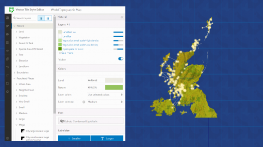
Blog Esri UK Tech Blog CategorySelect-- Select Category --3DCartographyContentData ManagementDeveloperMobileProduct NewsSpatial AnalysisTipsTechnologySelect-- Select Technology --AppsArcadeArcGIS EnterpriseArcGIS Experience BuilderArcGIS Living AtlasArcGIS OnlineArcGIS ProArcGIS StoryMapsDevelopersMobileReport Builder for ArcGISSweet for ArcGISUK ProductsUNE for ArcGISSearchSubmit Cartography Watermarkr your map 7th October 2022 With the retirement of Markr coming ever closer, you may be wondering “how can I add watermarks to my map?”. The answer is simple: all you need is an awesome logo in SVG format, a coverage layer in the coordinate … Read more Tips Getting to know the geofencing capabilities in the ArcGIS system 30th September 2022 Location is at the heart of everything we do here at Esri UK. So any capability that allows us to get even more from our location data is pretty powerful. And that’s exactly what geofencing is all about. Geo refers … Read more Tips Improving colour blindness accessibility in ArcGIS Pro 5th September 2022 There are an estimated 300 million people globally who suffer with colour vision deficiency (CVD), equating to 8% of the male population and 0.4% of the female population. Easily distinguishable colours such as red, green and blue, can appear extr... Read more Content Digging into the New British Geological Survey Geology Data 1st September 2022 Ever wondered what’s going on right beneath your feet? If your answer is yes, then keep reading to find out about our latest edition to the Living Atlas. The ArcGIS Living Atlas of the World is an evolving collection of … Read more Tips Engineering a better understanding of crime data in ArcGIS Pro 16th August 2022 In ArcGIS Pro you can now cluster point features to simplify data visualisation. Each cluster represents two or more features in the dataset, and by default, a text marker displays on top of the cluster to communicate the number of … Read more Product News Sweet for ArcGIS summer release out now 12th August 2022 Sun, sea, and Sweet. That sounds like the perfect summer to me! Especially as we’ve just released version 8.2 of Sweet, now available on both ArcGIS Online and Enterprise. If you use Sweet on Enterprise you can install the latest … Read more Tips Never miss bin day again with ArcGIS Instant Apps 22nd July 2022 ArcGIS Instant Apps is a fantastic way of providing members of the public with the latest information. Are you a utility company that needs to provide service updates to customers, or a local council needing to inform their constituents of &hellip... Read more Content Hot off the press: Your ArcGIS Living Atlas of the World summer updates 6th July 2022 It’s been a jam-packed last few months for the UK Living Atlas. For this summer update, we have welcomed 134 new datasets and four new contributors including: the British Antarctic Survey, Welsh Government, Marine Scotland (part of the Scottish Go... Read more Content Land Cover – find out what your city is made of! 1st July 2022 The makeup of our cities plays a key role in our day to day lives and how we interact with our environment. To get a better understanding of where we live, we’ll be exploring what land cover our cities consist … Read more Tips Templates to tempt you in ArcGIS Experience Builder 21st June 2022 ArcGIS Experience Builder allows you to create tailored responsive web apps without the use of code. Built on the ArcGIS API 4.x for JavaScript, Experience Builder takes advantage of the amazing mapping capabilities in the new Map Viewer. You can ... Read more Spatial Analysis Transform pixels into information using ArcGIS 3rd May 2022 Over the last 10 years or so, imagery has been more widely adopted as part of an organisation’s set of core datasets. This is due partly to the decreasing costs of sourcing the imagery and the increasing availability of imagery, … Read more Cartography Want a ‘Starry Night’ inspired basemap? We Gogh you covered. 12th April 2022 Cartographers have always been influenced by artistic practices, so wouldn’t it be great if we could make maps in the style of our favourite paintings? This idea may seem a little outlandish but with the help of modern-day GIS technologies, &helli... Read more Pages: 1234567891011121314151617181920212223242526Load More